
Figures & data
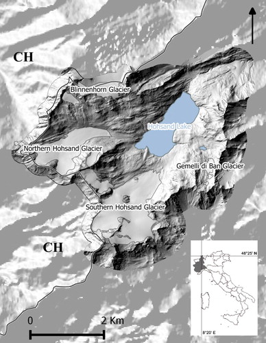
Figure 1. Shaded relief map of the study area (DTM produced by Regione Piemonte, with 5 m cell size). Solid line: Italy–Switzerland cross border.
Supplemental material
Figure 1. Shaded relief map of the study area (DTM produced by Regione Piemonte, with 5 m cell size). Solid line: Italy–Switzerland cross border.
Please note: Selecting permissions does not provide access to the full text of the article, please see our help page How do I view content?
To request a reprint or corporate permissions for this article, please click on the relevant link below:
Please note: Selecting permissions does not provide access to the full text of the article, please see our help page How do I view content?
Obtain permissions instantly via Rightslink by clicking on the button below:
If you are unable to obtain permissions via Rightslink, please complete and submit this Permissions form. For more information, please visit our Permissions help page.