Figures & data
Figure 1. Aerial photographs of Morsárjökull and its foreland (Landmælingar Islands for 1965 and 1980 and NERC ARSF for 2007), showing the glaciological features such as icefalls, ogives and supraglacial debris, including the 2007 rock avalanche debris immediately after its emplacement.
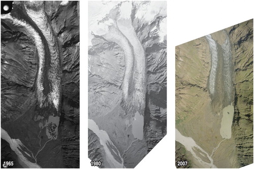
Figure 2. Ground photographs of Morsárjökull taken by Jack Ives in 1953: (a) the nunatak and backwall cliffs in the distance and the ogives and medial moraine and their relationship to the twin flow units of the glacier; (b) the ice falls and their relationship to the backwall cliffs and nunatak, showing the narrow connection of the west icefall to the valley glacier and the ice avalanches feeding the eastern ice flow unit.
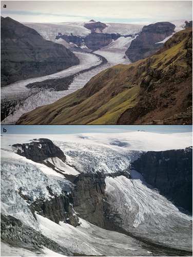
Figure 3. Variations since 1931 of the non-surge-type margins of the Vatnajökull South Region glaciers, using data from Veðurstofa Íslands (Icelandic Meteorological Office) and the Icelandic Glaciological Society. Data compilation by Ben Chandler. Note the period of advance for Morsárjökull and the nearby Öræfajökull outlets of Falljökull and Skaftafellsjökull from the early 1970s to the late 1980s.
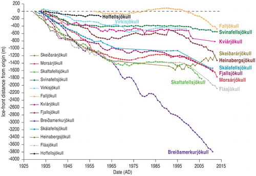
Figure 4. Historical changes of the Morsárjökull snout: (a) DEM showing ice margin position from 1903 to 2011 and the position of the rock avalanche debris in 2007, 2011 and 2017 (modified from CitationStötter et al., Citation2016); (b) longitudinal profile of the glacier and its underlying topography, showing ice thickness and snout margin through time. Also demarcated in light blue is the average ELA derived from MODIS satellite imagery (modified from CitationHannesdóttir et al., Citation2015).
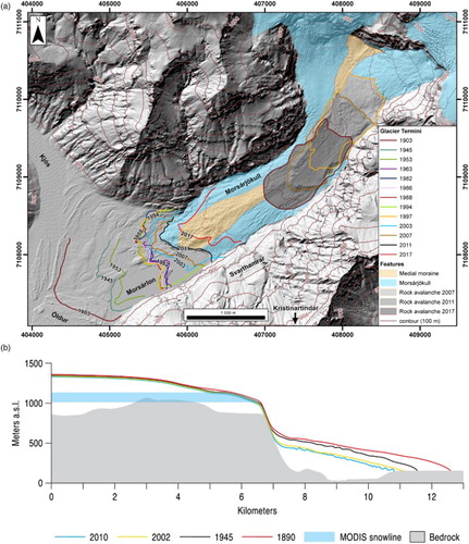
Figure 5. Glacial landforms and sediments of the Morsárjökull foreland: (a) large sawtooth moraine ridges (SM) and intervening glacifluvial outwash corridors (OC) produced where proglacial outwash was confined between moraine arcs on the northern foreland. This area of moraines is typical of the outer zone of slow snout recession dating to the period 1890–1903; (b) heavily fluted terrain (F) with relatively widely spaced push moraines (P) located in the central axis of the foreland and representative of relatively low debris provision and slow snout recession and readvances in the period 1970s–1990s. The large moraine complex in the centre of the image dates to around 1988 and was constructed around the time between the 1974 and 1989 advance period and 1990–1999 stillstand period; (c) heavily dissected and reworked moraines on the outer foreland, showing residual ‘islands’ of moraines isolated by relict and active braided outwash tracts. Note also the isolated large boulders let down onto the outwash after moraines have been completely reworked; (d) kame terraces (KT) and incised outwash developed on the proximal slopes of the immediately post-1903 sawtooth moraine complex (1903 SMC) on the south side of the foreland. Also clearly visible are isolated large boulders let down onto the outwash after moraine reworking.
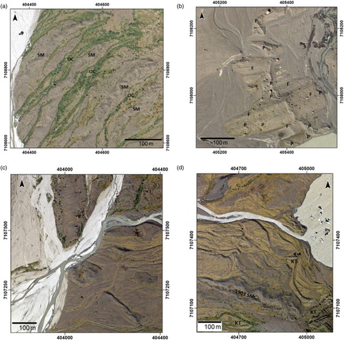
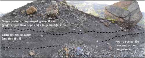
Figure 6. Stratigraphic exposure in the outermost arc of the Morsárjökull frontal moraines showing a vertical sequence comprising poorly sorted, ice-proximal outwash fan gravels at the base, overlain by compact and fissile structured, matrix-supported diamicton (subglacial till) and capped by crudely stratified to massive, clast-supported diamictons with distorted pockets of openwork gravels and gravelly sands (gravity mass flow deposits) containing large boulders. One metre high backpack is lying at the base of the section.