Figures & data
Figure 1. Structural sketch map of the Western Alps (modified from CitationBigi et al., 1990; and CitationPiana et al., 2017). The red inset shows the investigated area represented in the Main Map.
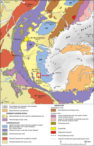
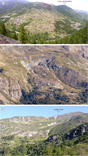
Figure 2. Panoramic view of the left side of the Varaita Valley. Red dashed line: tectonic contact between the Monviso meta-ophiolite Complex (MO) and the Dora-Maira Unit (DM). Yellow dashed lines: boundaries of the Pui-Orgiera landslide and related sectors (Ld1–Ld4). Blue lines: lateral moraine ridges related to the Last Glacial Maximum. Photo taken from Sampeyre Pass (2283 m a.s.l.), view looking N (Long. 7°07′09″, Lat. 44°33′04″).
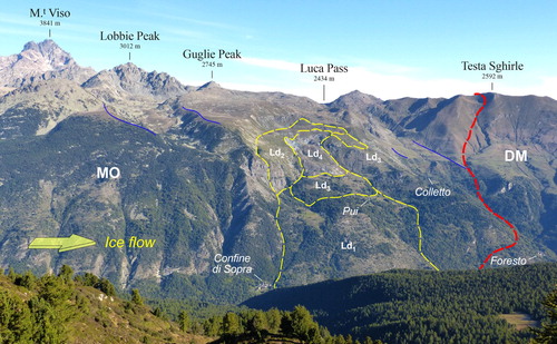
Figure 3. Field images of the meta-ophiolite succession of the MO. (a) Close up view of massive serpentinite laced by antigorite veins (dashed black lines) and crosscut by faults (dashed red lines) (Long. 7°7′55″, Lat. 44°35′51″). (b) E-W striking fault (dashed red lines) cutting the calcschist (Long. 7°8′47″, Lat. 44°35′43″). (c) Close up view of a meta-ophicarbonate horizon (Long. 7°8′43″, Lat. 44°36′47″). (d) Metabasite with relics of pillow textures (yellow dashed lines) (Long. 7°8′8″, Lat. 44°36′48″). Rocks and structures of the Baracun Shear Zone. (e) Contact between a block of metagabbro (Mg) and the talcschist (Ts) matrix (Long. 7°8′16″, Lat. 44°36′40″). (f) Blocks of metagabbro (Mg) embedded within the serpentine schist (Ss) matrix (Long. 7°8′51″, Lat. 44°37′39″).
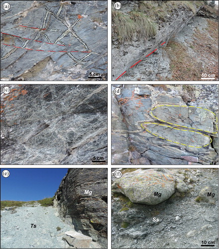
Figure 4. (a) A 400 m long counter slope involving talus deposits of Truc Plain is visible in the foreground (yellow triangles). Photo taken from Truc Plain (2440 m), view looking SSW (Long. 7°7′54″, Lat. 44°36′48″) . (b) Impressive uphill-facing scarp (yellow triangles), 750 m long, along the eastern margin of Truc Plain. Photo taken from Traversie (2500 m), view looking SSW (Long. 7°8′5″, Lat. 44°37′17″). Rg1 indicates an inactive rock glacier. (c) Antislope scarps (yellow triangles) involving the glacial till (Gt) and the lateral moraine system of the Lobbie glacier. Notice that the inactive rock glacier (Rg1) is not displaced by gravitational collapse. Photo taken from the southern slope of the Guglie Peak (2500 m a.s.l.), view looking SSW (Long. 7°7′15″, Lat. 44°37′1″).
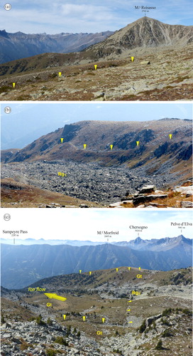
Figure 5. (a) Frontal view of the Ld1 sector of the Pui-Orgiera landslide. The Varaita River gorge is visible in the foreground. The red dashed line highlights the main scarp of the catastrophic reactivation of 1655. Photo taken from the right side of the Varaita Valley, East of Meire Gioanotta (1340 m a.s.l.), view looking NNE (Long. 7°7′43″, Lat. 44°34′40″). (b) Panoramic view of the upper part of the Pui-Orgiera landslide. Photo taken from Sampeyre Pass (2283 m a.s.l.), view looking N (Long. 7°07′09″, Lat. 44°33′04″). Ld1 to Ld4 represent the different landslide sectors. (c) Lateral view of the frontal sector of the Ld4 landslide. The impressive head scarp of the Pui-Orgiera landslide is visible in the foreground, involving the glacial till (Gt) of the Serre Plain. A large outcrop of metagabbro, meta-quartzdiorite and metaplagiogranite is visible on the right of the image. Photo taken from Croce del Gerbido (1628 m a.s.l.), view looking NW (Long. 7°8′54″, Lat. 44°35′30″).