Figures & data
Figure 1. Location of the study area. (A) Position of the study area in the Western Carpathians. (B) Location and borders of the Babia Góra Massif to the Main Map extent. (1 – Main streams, 2 – Borders of the Babia Góra Massif, 3 – National border, 4 – Settlements, 5 – Summits, 6 – Landslides)
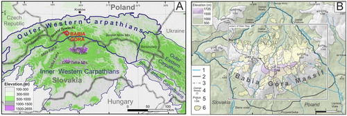
Figure 2. Geological map of the Babia Góra Massif based on CitationKsiążkiewicz (1971, Citation1983); CitationAleksandrowski (1985); CitationTeťák et al. (2016) and Geological Map of the Slovak Republic 1:50,000. Legend: 1 – Magura beds; thick-bedded sandstone-dominated flysch sequence (Upper Eocene); Sub-Magura beds: 2 – Bistrica beds; thin-bedded flysch and marls (Middle Eocene), 3– Beloveža Beds; thin-bedded flysch (Middle Eocene), 4 – Hieroglyphic Beds; thin-bedded flysch (Middle Eocene), 5 – Osielec sandstones (Eocene), 6 – Variegated shales, red and variegated shales (Paleocene–Eocene), 7 – Ropianka Beds; thin- and medium-bedded flysch (Late Cretaceous–Paleocene), 8 – Szczawina sandstones; thick-bedded sandstones and conglomerates (Late Cretaceous), 9 – Alluvial cones (Pleistocene), 10 – River terrace (Holocene), 11 – Faults, 12 – Triangular facets, 13 – Mineral springs, 14 – National border.
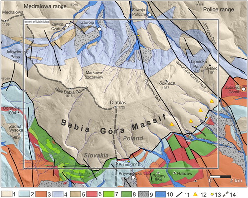
Figure 3. Morphological asymmetry of the Babia Góra Massif. (A) North-exposed escarpment slope, (B) South-exposed dip slope. Main Map projected on the LiDAR DTM. White circles refer to the location and number of large rock slope failures, its morphometrical characteristics are presented in Supplementary Data 1. Symbols in squares refer to the location of landforms presented in , and .
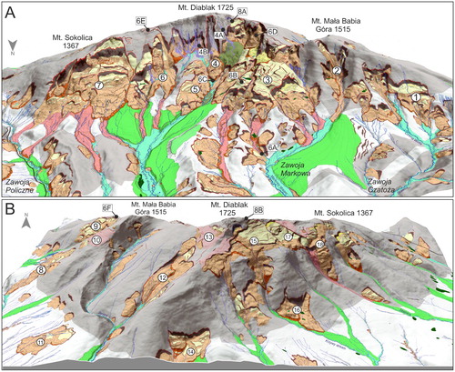
Figure 4. Hillslope landforms in the Babia Góra Massif. (A) The longest (760 m) modern debris flow track formed in 2002 on the northern slope of the Babia Góra Massif. (B) Relict debris flow gully at Urwisko site.
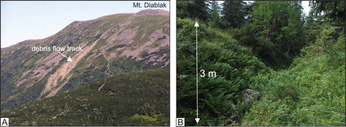
Figure 5. RSF inventory map of the Babia Góra Massif.
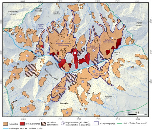
Figure 6. Rock slope failures in the Babia Góra Massif. (A) Front of a complex flow-like rockslide in the Barańcowy stream valley. Angular sandstone debris at the surface of a flow-like landform. (B) Tilted translated block of the Markowe Szczawiny rockslide. (C) Distinct, 30 m high front of the Szeroki Żleb rock avalanche. (D) Debris field of the Kościółki rock avalanche. (E) Rock slope deformations (RSD) at Zimna Dolinka site. (F) Extensional trench with the entrance to the Złota Studnia crevice-type cave in the upper part of the Hlasna rieka RSD.
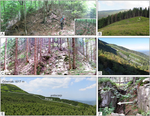
Table 1. RSFs size data for the Babia Góra Massif.
Figure 7. Rock slope failure area for the altitude in the Babia Góra Massif. (A) Distribution of altitude within RSF terrain and all massif area (B) Ratio of the landslide area within each class for altitude (C) Maximum altitude of landslide scarp areas.
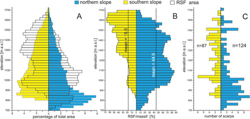
Figure 8. Periglacial landforms in the Babia Góra Massif. (A) Periglacial blockfields at the Babia Góra ridge. (B) Relict pronival rampart and nivation hollow on the NE face of Mt. Diablak.
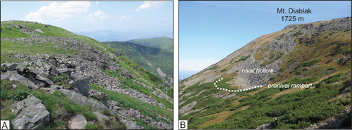
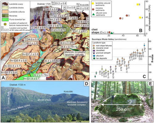
Figure 9. Glacial landforms and sediments at the Babia Góra Massif. (A) Spatial distribution of Schmidt Hammer rebound values in the Szumiąca Woda Valley plotted on the Main Map projected on the LiDAR DEM. (B) Co-variance plot for the main sediments types in the Szumiąca Woda valley. Site location showed at panel A. (C) Mean R-values with SEM intervals for the landforms in the Szumiąca Woda Valley. Numerals in the graph refer to measurement locations in panel A. R-values for the fans were adopted from CitationKłapyta and Kolecka (2015). (D) General view on the glacial cirque between Diablak and Kościółki Mts. (E) Large sandstone boulder at the frontal part of terminal moraine in the Szumiąca Woda Valley.