
Figures & data
Figure 1. Studied cities in the context of the historical regions of the Czech Republic (data sources: © ArcČR500, ARCDATA Prague, 2016).
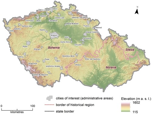
Table 1. The studied attributes of former ponds.
Figure 2. Main results from analysis of former ponds in the 34 city administrative areas.
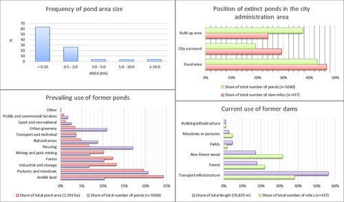
Figure 3. Former pond areas and length of dam relics: (a) Summary for studied cities; (b) City of Pardubice – position of former ponds from the old maps and former dams visible on the DTM (data source: © ČÚZK).
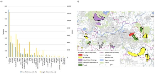
Figure 4. Examples of relics of the dam in city administrative areas: (a) Relic of a massive dam of the former pond Točník which is used as a road embankment (city: Klatovy; old map: 1MS); (b) Half of the former dam of the pond covered by non-forest woody vegetation (city: Písek; old map: 2MS); (c) Relics of dams in the woods near the city Jihlava (old map: 1MS). Source: © ČÚZK; © Austrian State Archives [Österreichisches Staatsarchiv] – all rights reserved (survey, z.B. ‘Josephinische Landesaufnahme’ / ‘First military survey’), Mapire.eu; © Czech National Geoportal (CENIA).
![Figure 4. Examples of relics of the dam in city administrative areas: (a) Relic of a massive dam of the former pond Točník which is used as a road embankment (city: Klatovy; old map: 1MS); (b) Half of the former dam of the pond covered by non-forest woody vegetation (city: Písek; old map: 2MS); (c) Relics of dams in the woods near the city Jihlava (old map: 1MS). Source: © ČÚZK; © Austrian State Archives [Österreichisches Staatsarchiv] – all rights reserved (survey, z.B. ‘Josephinische Landesaufnahme’ / ‘First military survey’), Mapire.eu; © Czech National Geoportal (CENIA).](/cms/asset/230f4a9c-64ab-4c7e-8fac-3ca31f80d4f6/tjom_a_1819900_f0004_oc.jpg)
Figure 5. Place names connected with former ponds in urban landscape: (a) Street Rybniční (Pond street) which refers to one of the former ponds and copies the original pond dam (city: České Budějovice); (b) Enclave of the village Spojil in the administration area of the city of Pardubice, which was built on the bottom of the pond of the same name Spojil. Source: © OpenStreetMap; © Austrian State Archives [Österreichisches Staatsarchiv] – all rights reserved (survey, z.B. ‘Josephinische Landesaufnahme’ / ‘First military survey’), Mapire.eu; © Czech National Geoportal (CENIA).
![Figure 5. Place names connected with former ponds in urban landscape: (a) Street Rybniční (Pond street) which refers to one of the former ponds and copies the original pond dam (city: České Budějovice); (b) Enclave of the village Spojil in the administration area of the city of Pardubice, which was built on the bottom of the pond of the same name Spojil. Source: © OpenStreetMap; © Austrian State Archives [Österreichisches Staatsarchiv] – all rights reserved (survey, z.B. ‘Josephinische Landesaufnahme’ / ‘First military survey’), Mapire.eu; © Czech National Geoportal (CENIA).](/cms/asset/5925182c-3040-4231-887d-13d23ca23551/tjom_a_1819900_f0005_oc.jpg)
Figure 6. Uncertainty about the reconstruction of water area of pond: red line – pond water area according to 1MS; yellow line – wet meadow according to 2MS; white lines – contours Data source: © Austrian State Archives [Österreichisches Staatsarchiv] – all rights reserved (survey, z.B. ‘Josephinische Landesaufnahme’ / ‘First military survey’), Mapire.eu; ; © Czech National Geoportal (CENIA); © ZABAGED; ČÚZK.
![Figure 6. Uncertainty about the reconstruction of water area of pond: red line – pond water area according to 1MS; yellow line – wet meadow according to 2MS; white lines – contours Data source: © Austrian State Archives [Österreichisches Staatsarchiv] – all rights reserved (survey, z.B. ‘Josephinische Landesaufnahme’ / ‘First military survey’), Mapire.eu; ; © Czech National Geoportal (CENIA); © ZABAGED; ČÚZK.](/cms/asset/e795eafa-af09-4257-a907-474d1db0fc7d/tjom_a_1819900_f0006_oc.jpg)
Figure 7. Limits of the old maps: (a) Different numbers of ponds and their depiction between two map sources (city: Jindřichův Hradec); (b) Different styles of displaying ponds on the map sheets of 1MS. Source: © Austrian State Archives [Österreichisches Staatsarchiv] – all rights reserved (survey, z.B. ‘Josephinische Landesaufnahme’ / ‘First military survey’), Mapire.eu; ; © Czech National Geoportal (CENIA).
![Figure 7. Limits of the old maps: (a) Different numbers of ponds and their depiction between two map sources (city: Jindřichův Hradec); (b) Different styles of displaying ponds on the map sheets of 1MS. Source: © Austrian State Archives [Österreichisches Staatsarchiv] – all rights reserved (survey, z.B. ‘Josephinische Landesaufnahme’ / ‘First military survey’), Mapire.eu; ; © Czech National Geoportal (CENIA).](/cms/asset/813353d7-24f7-42e8-acd6-b1135a561cca/tjom_a_1819900_f0007_oc.jpg)