
Figures & data
Figure 1. Colored shaded-relief image of the South Aegean Sea from mosaicked digital elevation models (DEMs) of onshore Advanced Spaceborne Thermal Emission and Reflection Radiometer (ASTER) data (30 m/pixel) and offshore European Marine Observation and Data network (EMODnet) data (107 meters/pixel); artificially illuminated from the northwest. Box represents map area; red triangles offset from centers of the Hellenic Volcanic Arc. Sawteeth on hanging wall of reverse fault; hachures point downslope.
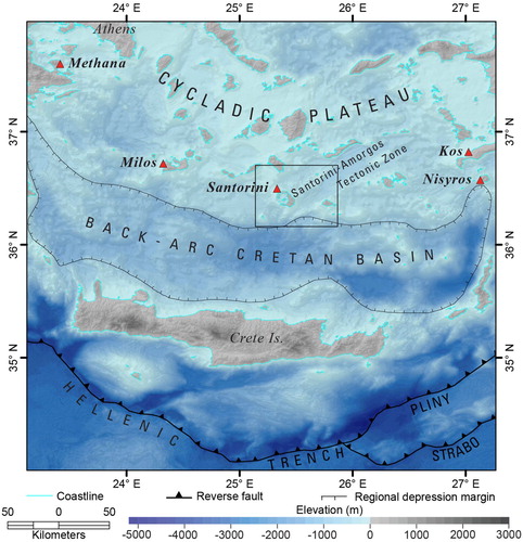
Figure 2. Shaded-relief image of the Christiana-Santorini-Kolumbo Volcanic Group and surrounding geographic features from mosaicked ASTER and EMODnet DEMs; artificially illuminated from the northwest. Box represents map area; colors represent data coverage: onshore ASTER data (30 m/pixel), offshore EMODnet data (107 m/pixel), and offshore ‘Plumbing Reservoirs Of The Earth Under Santorini’ (PROTEUS) data (20 m/pixel) merged with swath data from previous surveys (Hooft et al., Citation2017; Nomikou et al., Citation2012, Citation2013; Nomikou et al., Citation2014); white areas undefined due to missing data which is typical in the foreshore (intertidal) region. Faults adapted from CitationHooft et al. (Citation2017); ball and bar on hanging wall.
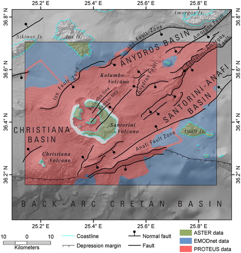
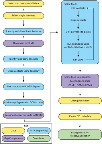
Figure 3. Workflow for creating a geomorphologic map. ESRI ArcGIS terms used for GIS components; map components adapted from USGS guidelines (Skinner et al., Citationin press; USGS NCGMP, Citation2020).
Supplemental Material
Download PDF (31.9 MB)Data availability
The authors confirm that the GIS data generated by this study are available within the article [and/or] its supplementary materials.
The digital elevation model (DEM) data that support the findings of this study are openly available. The EMODnet and PROTEUS data that support the findings of this study are openly available in the EMODnet Bathymetry portal at https://portal.emodnet-bathymetry.eu. Data are hosted by the CitationEMODnet Bathymetry Consortium (Citation2018), at http://doi.org/10.12770/18ff0d48-b203-4a65-94a9-5fd8b0ec35f6.
The ASTER data that support the findings of this study are openly available in the NASA Earth Data Search at https://search.earthdata.nasa.gov/search. Data are hosted by the NASA EOSDIS Land Processes DAAC, at https://doi.org/10.5067/ASTER/ASTGTM.003.