
Figures & data
Figure 1. Continental and regional setting of valleys mapped in this study. (b) Regional setting of mapped valleys, including the location of the main outlet glaciers: P: Río Pico, Ca: Río Caceres, C: Río Cisnes, PF: Lago Plata-Fontana, T: El Toqui, Ñ: Lago Coyt/Río Ñirehuao, SP: Simpson/Paso Coyhaique, and B: Balmaceda. LGC/BA: Lago General Carrera-Buenos Aires. Arrows represent main ice-flow directions. (a) Southern South America, including the mapped area. NPI: Northern Patagonian Icefield; SPI: Southern Patagonian Icefield; CDI: Cordillera Darwin Icefield. Ice extent at 35 ka is also presented and was extracted from PATICE (CitationDavies et al., Citation2020). Modern ice extent from RGI v. 6.0, region 17 (CitationArendt et al., Citation2017).
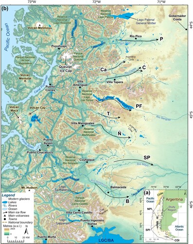
Figure 2. The location of published mapping between 44° and 46°S. Mapping type has been included: field or remotely sensed, as well as mapping extent. Where detailed maps or georeferenced locations were not available (), mapping extent has been estimated according to the data that has been described in each publication (legend: previous mapping). Areas that were field verified in this study have also been included (grey boxes). Modern ice extent from RGI v. 6.0, region 17 (CitationArendt et al., Citation2017). LGC/BA: Lago General Carrera-Buenos Aires.
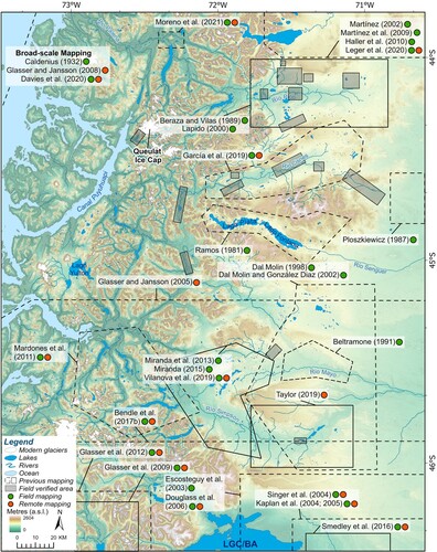
Table 1. Relevant glacial geomorphological landforms and glacier inventories presented in studies from , described using the terminology presented in this paper.
Figure 3. Broad geomorphological context of mapped valleys, including key moraine complexes. It is likely that the stratigraphically oldest moraine complexes span multiple glacial advances. Moraine complexes were mostly identified from remote mapping and should be field verified. Outlet glaciers: P: Río Pico, Ca: Río Caceres, C: Río Cisnes, PF: Lago Plata-Fontana, T: El Toqui, Ñ: Lago Coyt/Río Ñirehuao, SP: Simpson/Paso Coyhaique, and B: Balmaceda. Location and extent of maps presented in have also been included (black boxes) and photos of glaciolacustrine sediments (red dots). Modern ice extent from RGI v. 6.0, region 17 (CitationArendt et al., Citation2017).
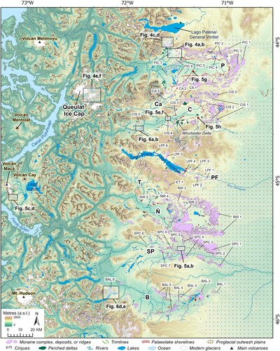
Figure 4. Ice-marginal landforms within the main outlet valleys and the Andean Cordillera. Raw satellite images (left) and mapped geomorphology (right). (a) Satellite image of central-northern sector of the Río Pico valley, including the location of (g). (b) Mapped landforms, including the PIC 6 moraine and an associated proglacial outwash plain. (c) Satellite image of a morainal bank, which is the lateral margin of the PIC 6 moraine, and a small isolated palaeolake basin in the northern Río Pico valley. (d) Mapped landforms surrounding the PIC 6 morainal bank, which is adjacent to ice-contact fans, and multiple, stepped, palaeolake shorelines. (e) Satellite image of the area southeast of the Queulat ice cap. (f) Mapped moraines and trimlines associated with the stratigraphically youngest glacier advances in the Andean Cordillera. (g) Ice-proximal view of the PIC 6 moraine in the field overlooking older moraines and terminating into a proglacial outwash plain. Satellite images are from ESRI™ DigitalGlobe World Imagery via ArcGIS Pro. Figure panel locations are shown in .
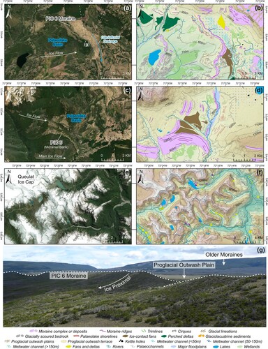
Figure 5. Subglacial and glaciolacustrine landforms and sediments. (a) Satellite image of glacial lineations in the Simpson/Paso Coyhaique valley. (b) Mapped glacial lineations in the Simpson/Paso Coyhaique valley, dissected by proglacial outwash plains. Glacial lineations are aligned in a west-east and southwest-northeast direction, and adjacent to moraine complexes or deposits. (c) Satellite image of recently deglaciated ice cap south of Volcán Macá. (d) Flutes mapped within the Andean Cordillera which demonstrate multiple, diverging, local ice-flow directions. (e) Satellite image of the CIS 4 moraine, Río Cisnes valley. (f) Short-lived, narrow, palaeolake shorelines embedded on the CIS 4 moraine. (g) Laminated glaciolacustrine sediments located in the centre of the Río Pico palaeolake basin. (h) Glaciolacustrine sediments dissected by a tephra layer (cf. CitationStern et al., 2015) in the Río Cisnes valley.
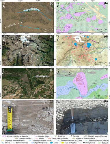
Figure 6. Examples of glaciofluvial landforms in the study area. (a) Location of catastrophic flood landforms and direction of final palaeolake drainage in the Río Cisnes valley. (b) Mapped catastrophic flood landforms along the banks of the modern Río Cisnes, adjacent to the CIS 5 moraine. Includes the location of (c). (c) Catastrophic flood landform in the foreground, adjacent to the CIS 5 moraine. (d) Location and ice-flow direction at Lago La Paloma, the site of a tributary glacier of the main Balmaceda valley. (e) Mapping of the La Paloma glacier, including moraine ridges and proglacial outwash terraces. Proglacial outwash terraces indicate that glaciofluvial drainage from the La Paloma glacier was directed towards the main Balmaceda valley.
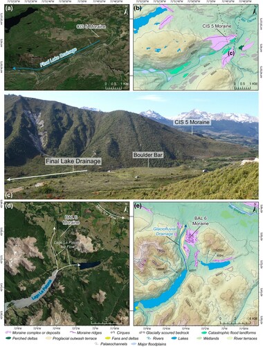
Table 2 . Rationale, uncertainties, and identification criteria for ice-marginal, subglacial, glaciolacustrine, glaciofluvial, and non-glacial landforms mapped between 44 – 46°S. Total mapped landform numbers and/or areas are provided where applicable. Landform occurrence (✘) within the study region: P: Río Pico outlet glacier, Ca: Río Caceres outlet glacier, C: Río Cisnes outlet glacier, PF: Lago Plata-Fontana outlet glacier, T: El Toqui outlet glacier Ñ: Lago Coyt/Río Ñirehuao outlet glacier, SP: Simpson/Paso Coyhaique outlet glacier, B: Balmaceda outlet glacier, and A: landforms mapped within the Andean Cordillera. Identification criteria were modelled after CitationBendle et al. (Citation2017b), CitationMartin et al. (Citation2019), and CitationLeger et al. (Citation2020): criteria were then modified and updated for the study area.
Supplemental Material
Download Zip (103.4 MB)TJOM_1986158_supplemental material
Download PDF (49.4 MB)Data Availability Statement
All shapefiles are available in the supplementary materials of this paper.