
Figures & data
Table 1. The International Phonetic Alphabet (revised to 2020).
Table 2. The main scripts and languages in the map area.
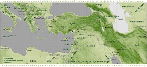
Figure 1. Wall map at the Faculty of Arts, University of Ostrava, with features described using the International Phonetic Alphabet.
Map of the Middle East shows the countries within the selected area, their capital cities, cities with a population of more than 500 000, rivers, lakes and seas. The capital cities are marked with a different symbol than the other cities. Features are described by means of transcriptions of the pronunciation of geographical names in the original language using International Phonetic Alphabet (IPA). Terrain elevation is shown with a color scheme varying between pale green for low elevations and dark green for high elevations. The frame of the map consists of the symbols of the IPA. It is merely a map field lacking a title and other compositional elements.
Supplemental material
TJOM_1996477_Supplementary File
Download PDF (2.1 MB)Data availability statement
The data that support the findings of this study are available from Esri (www.esri.com) and they are provided as a basic data for ArcGIS software from Esri. Vector data and raster data were used. The raster data represent the terrain. The vector data depict the basic geographical features: cities, rivers, national borders, lakes and seas.