
Figures & data
Figure 1. Location of the Aran Valley within the Pyrenean range, including the main lithological units of the study area.
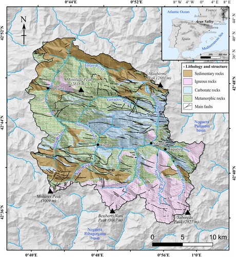
Figure 2. Steps followed during the elaboration of the geomorphological map; (A) combination of hillshade (40% transparent) with orthophotomaps; (B) first draft of the geomorphological map; (C) field validation of the first geomorphological draft with pictures, such as till cover (C1), superficial deformation of till cover at the plateau (C2), peat area (C3), and alluvial fan (C4). (D) final geomorphological map respecting the Main map legend.
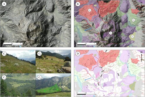
Table 1. Attributes of the remote sensing products used for the geomorphological map.
Table 2. Location and morphological characteristics of the landforms and processes drew in the Main map.
Figure 3. Examples of the different glacial landforms identified in the area: (A) lateral moraine around 1600 m at the Nère Valley; (B) E-W perspective of the main Garonne Valley with an erratic boulder of granite distributed on a slate outcrop above Salardú village; (C) glacial lake distributed in an overdeepened basin at the Unhòla Valley; (D) glacial cirque of the Montardo Peak at the Valarties Valley.
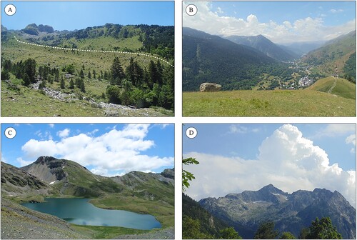
Figure 4. Examples of the different periglacial landforms identified in the area: (A) relict rock glacier distributed across the glacial cirque floor of Locampo, Ruda Valley; (B) active talus slope with protalus lobes at the Nère Valley; (C) relict block stream at 2200 m in the Ruda Valley; (D) inactive sorted cirques at 2480 m in the Mauberme cirque, Unhòla Valley.
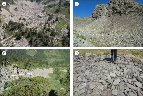
Figure 5. Examples of other geomorphological landforms identified in the area: (A) long-lying snow patch at 2350 m, in the north face of the Armèros Peak; Unhòla Valley (B) dolines located in the Sascorjada glacial cirque, Toran Valley; (C) Rock slope deformation at the Varradòs Valley; (D) alluvial fan connected with the fluvial plain at the Joèu Valley.
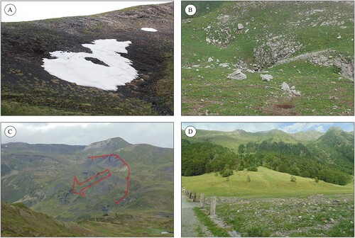
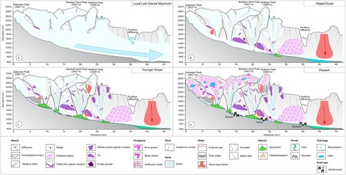
Figure 6. Sequence of environmental phases shaping the landscape of the Aran Valley: (A) maximum ice extent of the last glacial cycle; (B) glacial tongues flowing downvalleys during a glacial advance/standstill (Oldest Dryas) within the long-term glacial retreat of the Garonne paleoglacier that favored also intense slope readjustment; (C) alpine and cirque glaciers (Younger Dryas) with very intense postglacial slopes dynamics, and the occurrence of permafrost that promoted the formation of rock glaciers; (D) deglaciated cirques with periglacial processes prevailing at higher elevations (inactive rock glaciers), and slope, alluvial and fluvial processes at lower elevations.
TJOM_A_2035266_Supplementary material
Download PDF (21.5 MB)Data availability statement
The data described in this article are openly available at the ZENODO data repository (https://doi.org/10.5281/zenodo.4644265).