
Figures & data
Figure 1. (A) Shaded relief map from multibeam bathymetric data of the eastern Sardinian margin. The continental shelf is in general narrow. Numerous canyons are present in the slope and feed deep-sea fans in the intra-slope basins. The latter are bounded seaward by structural highs. (B) Schematic cross-section illustrating the structural and stratigraphic setting of the eastern Sardinia margin down to the Vavilov back-arc area (location in a; the eastern part of the map lies outside from the map of a). Note the staircase of basin formed in extensional structural troughs. (C) Sesimic line BC44 showing the structures of the Olbia Basin, the most northern intraslope basin in the Sardinia margin (location in a). The purple line marks the base of the Plio-Quaternary succession.
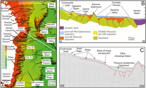
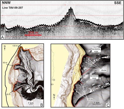
Figure 2. (A) Subbottom Chirp profile in the southern part of the Tavolara sheet. The central high corresponds to a submerged coastal feature formed presumably during the last sea-level rise (see location in a). (B) Shaded relief from multibeam bathymetric data of the Gonone canyon system (see location in a). Landslides scars are ubiquitous along the canyon headwalls and flanks. Chutes are also present. Seafloor undulation in the most southern canyon is of the ‘cyclic step’ type. Inner thalwegs leave erosional terraces on the main axis of the canyon. (C) The Santa Maria Navarrese canyons (see location in a). The canyon heads show landsliding and gullying that form indentation in the shelf edge. Landslide blocks are present in the canyon heads, and landslide also affects the flank of the canyons. Cyclic steps form in the lower part of both canyons.
14GF the Eastern Sardinia marginGamberi.pdf
Download PDF (32.7 MB)Data availability statement
Data will be made available by the Authors upon reasonable requests.