
Figures & data
Figure 1. (A) Tectonic evolution of the central-western Mediterranean, from 20 to 7 Ma. The 10° and 23° CCW rotations of the Corso–Sardinian block is represented using as reference the fixed European block. Legend: (1) Alpine wedge; (2) pole for the Corsica–Sardinia rotation; (3) arc-related volcanics (e.g. CitationBeccaluva et al., 1985; CitationLonergan & White, 1997; CitationSerri et al., 1993 and references therein). The 20 Ma Corse–Sardinia position is inferred from CitationGattacceca (2001) (modified by CitationSperanza et al., 2002). (B) Simplified sketch of the northern Sardinia margin showing the two main Oligocene–Miocene offshore basins and the associated faults (modified based on the work of CitationThomas & Gennesseaux, 1986). The draft of offshore Miocene volcanism from the south-western Corsica margin has been adapted from CitationRollet et al. (2002).
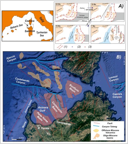
Figure 2. Sections from seismic data: (A) Porto Torres Basin (B) Castelsardo Basin (C) Bonifacio Basin; legend: (1) normal (?) fault; (2) basement; (3) Oligocene–Miocene sedimentary and volcanic sequences; (4) Pliocene–Quaternary sequences (from CitationThomas & Gennesseaux, 1986, simplified).
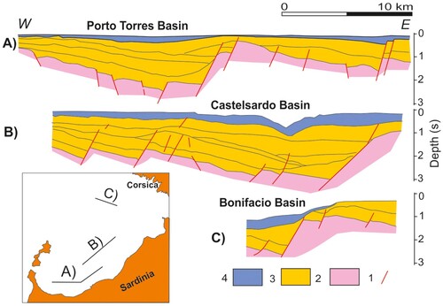
Figure 3. 3D blocks of the Digital Elevation Model (DEM), showing the main morphological features of Castelsardo Canyon; (A) main canyon talweg and a left-lateral tributary channel detached from the main canyon axis by a 300 m-high scarp; (B) meandering course of the canyon axis; and (C) examples of morphological reactivation within a tributary channel flowing into the canyon from the eastern side.
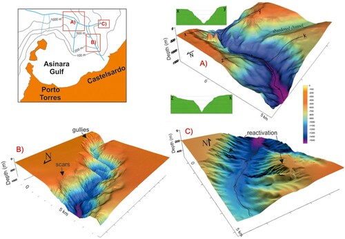
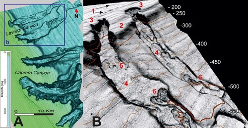
Figure 4. (A) Shaded relief from the DEM of the NE Sardinian continental margin. (B) 3D block of the Lavezzi canyon heads: (1) beach-rocks at 100 m depth; (2) edge of the prograding continental shelf; (3) retrogressive canyon head; (4) intracanal deposit from upslope failures; (5) erosional bedforms from channelized flows; and (6) retrogressive failure undermining the toe of former landslide deposits, perching within the channel axis.
17_G_F_of the Northern Sardinia margin_Conforti.pdf
Download PDF (29.5 MB)Data Availability Statement
Data are available upon reasonable request by contacting the first authors at the mail address: [email protected], [email protected].