1,977
Views
21
CrossRef citations to date
0
Altmetric
ORIGINAL ARTICLES

Can the river location within a fjord explain the density of Atlantic salmon and sea trout?

, , , , , , & show all
Pages 268-278 | Accepted 13 Aug 2012, Published online: 15 Oct 2013

Figures & data

Figure 1. Map of the Hardangerfjord and all anadromous rivers in the study. Note the arrow from which the distance from the fjord outlet to the river was measured.

Table I. Categorization of rivers in the Hardangerfjord. Shortened code is abbreviation of name used in graph. Area is the area of river polygons from digital maps using ArcGis©. Length is distance from anadromous obstacle to river outlet following a transect in the middle of the river. Distance is distance from river outlet to outlet of the Hardangerfjord (Bømlafjord). Glacier is presence of glacier in the catchment. Physical is a categorization of the human physical alteration of the river. Regulation is the presence of river regulation in the river. Discharge is the categorization of whether the discharge has been severely reduced.

Figure 2. Pre-fisheries abundance (upper panel) and fish per hectare (lower panel) of wild Atlantic salmon observed in the rivers of the Hardangerfjord in the period 2004–2011. For rivers codes, see . Grey symbols indicate values from 2011.
Figure 2. Pre-fisheries abundance (upper panel) and fish per hectare (lower panel) of wild Atlantic salmon observed in the rivers of the Hardangerfjord in the period 2004–2011. For rivers codes, see Table I. Grey symbols indicate values from 2011.
Figure 3. Pre-fisheries abundance (upper panel) and fish per hectare (lower panel) of sea trout observed in the rivers of the Hardangerfjord in the period 2004–2011. For rivers codes, see . Grey symbols indicate values from 2011.
Figure 3. Pre-fisheries abundance (upper panel) and fish per hectare (lower panel) of sea trout observed in the rivers of the Hardangerfjord in the period 2004–2011. For rivers codes, see Table I. Grey symbols indicate values from 2011.
Figure 4. Salmon per hectare versus distance to coast where each plot represents a year from 2004 to 2011. Grey names denote rivers where a significant part of the water discharge has been reduced. For rivers codes, see . Etneelva is in some cases out of scale and the values are denoted in the upper right corner. Both the linear mixed effect model with (dashed line) and without (solid line) data from Etneelva is plotted in each graph.
Figure 4. Salmon per hectare versus distance to coast where each plot represents a year from 2004 to 2011. Grey names denote rivers where a significant part of the water discharge has been reduced. For rivers codes, see Table I. Etneelva is in some cases out of scale and the values are denoted in the upper right corner. Both the linear mixed effect model with (dashed line) and without (solid line) data from Etneelva is plotted in each graph.

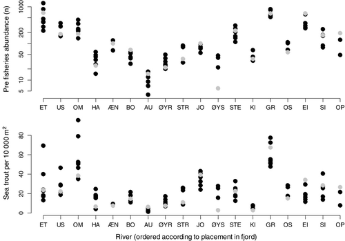
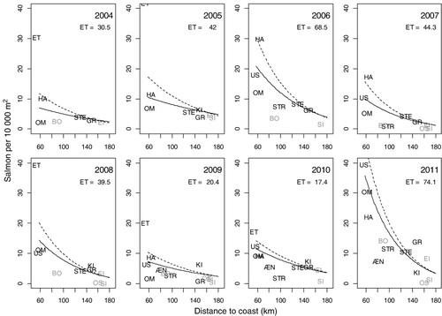
Table II. Results of the linear mixed-effects model of density of fish (DF) without river Etne. River is defined as a random effect. The standard deviation (s.d.) of the random effect and the residual SD was 0.49 and 0.38, respectively; numDF and denDF represent the numerator and denominator degrees of freedom in the test of the respective factors.

Figure 5. Sea trout per hectare versus distance to coast where each plot represents a year from 2004 to 2011. Grey names denote rivers where a significant part of the water discharge has been reduced. For rivers codes, see .
Figure 5. Sea trout per hectare versus distance to coast where each plot represents a year from 2004 to 2011. Grey names denote rivers where a significant part of the water discharge has been reduced. For rivers codes, see Table I.
Figure 6. Total number of observed farmed salmon (upper panel) and estimated percent farmed salmon in spawning populations (lower panel). For rivers codes, see . Grey symbols indicate values from 2011.
Figure 6. Total number of observed farmed salmon (upper panel) and estimated percent farmed salmon in spawning populations (lower panel). For rivers codes, see Table I. Grey symbols indicate values from 2011.