Figures & data
Table 1. Model assumptions used in calculating national-level totals of settlement and infrastructure area as a function of population density and development status. Sources: see text
Table 2. Classification of grazing land on basis of land cover information (GLC2000) and potential productivity patterns (calculated with the LPJ-DGVM; Gerten et al., Citation2004; Sitch et al., Citation2003)
Figure 1. Patterns of land use. (a) Urban and infrastructure area, (b) cropland, (c) forestry, (d) wilderness and unproductive area. Greenland and Antarctica excluded. (Available in colour online)
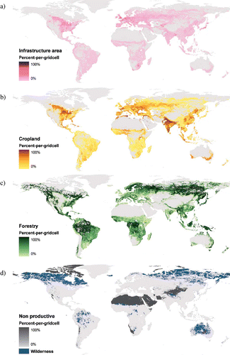
Figure 2. Patterns of land use. (a) Grazing land and (b) grazing suitability classes: 1 high suitability, 4 low suitability. Greenland and Antarctica excluded. (Available in colour online)
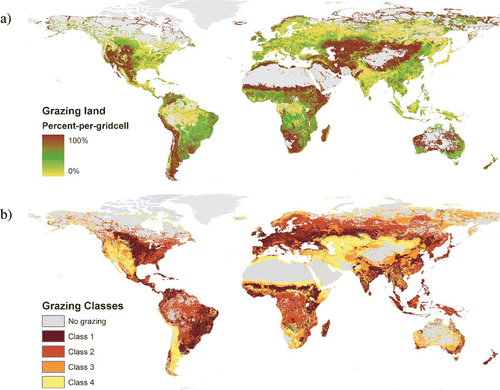
Table 3. Global quantitative result and comparison with original data sources and alternative data. Data exclude Greenland and Antarctica; regional sub-samples in italics
Table 4. Spatial statistics of the land use maps and alternative land use/land cover maps intercomparison. Hurtt (Citation2001) refers to the national model presented in that article. B: Boolean representation, fc: fractional coverage. Greenland and Antarctica excluded from the analysis
Figure 3. Estimates of urban and infrastructure land use in those countries with census data (see text) and the countries represented in the CLC2000 (Joint Research Center, Citation2006) (y-axis) plotted versus the national result of our urban and infrastructure layer (x-axis). Note the logarithmic representation of both axes. The straight line indicates 1:1 correspondence for interpretation.
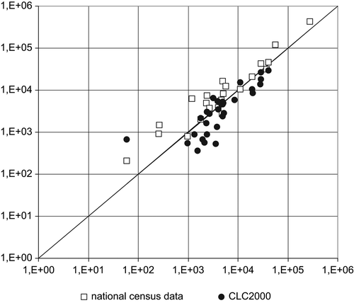
Figure 4. Comparison of the permanent pasture map by Klein-Goldewijk Citation(2001) and the grazing land layer. Greenland and Antarctica not included. For discussion see text. (Available in colour online)
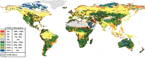
Figure 5. Histogram of difference in percent fractional cover in each 5 min gridcell of (a) forest cover, (b) bare cover, (c) herbaceous cover of the MODIS layers and the corresponding land use layers. x-axis representation: land use layers minus MODIS.
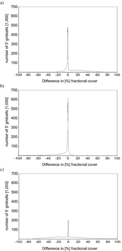
Table A1. National land use area estimates and comparison with statistical census data. [1] = our estimate
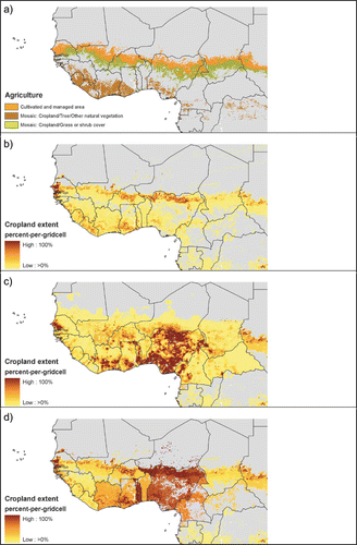
Figure A1. Comparison of cropland estimates for West Africa. (a) Agricultural land cover according to the GLC2000, (b) cropland map of Ramankutty and Foley Citation(1999), (c) cropland map of Ramankutty Citation(2004), and (d) our cropland result. The adjustment of the cropland extent in our data (d) to national census data () is based on map (b) and results in discernible national boundaries. The result is similar to the pattern in map (c) which approximates (but does not reproduce) FAO cropland data on the national level. Note the disparities of all three cropland maps (b,c,d) with the GLC land cover map (a). We conclude that a satisfactory representation of cropland in that region remains elusive. (Available in colour online)