Figures & data
Figure 1. Diagram presents relationship among the five tasks in the Exupéry VFRS.
Note: The first task provides classic seismic and novel (high-resolution local deformation measurements and terrestrial gas measurements) observation systems to the VFRS. In order to provide the data collected in the field in real time to the database a reliable wireless communication including sufficient bandwidth is necessary. The second task includes space-based observations into the VFRS; in the recent years developments in space-based observations have opened up a new field in volcanology allowing the mapping of deformation, identification of broad degassing signatures, and the detection of thermal anomalies. The third task is a central for the whole system. It allows storing, browsing, accessing, and visualizing multi-component datasets (raw and/or parameterized) recorded at active volcanoes during a crisis. The fourth task works on changes in a volcano stress distribution. None of the methods available at hand provides a direct assessment of the stress or even better changes in the stress distribution. It is therefore necessary to further process the incoming data, if possible in real time, to better characterize stress changes. The fifth task is in charge of the overall project coordination and prototype installation (Azores, April–September 2009).
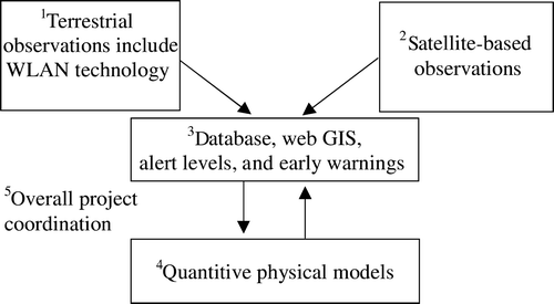
Figure 2. A sample scene of the web GIS interface showing the activity observed by the GPS network (no activity can be seen in the time plot).
Note: Controls for navigation, time filter, and seismic data are located together with the active layers list on the left side of the interface. Controls for project managing are located on the right side of the upper bar.
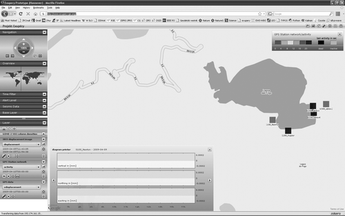
Figure 3. Layer list with three sample layers; one can add or remove layer(s), set the layer visualization style, show layer legend, change layer time span, toggle layer visibility, fit layer to the screen, and pick detail data by a mouse click on a layer.
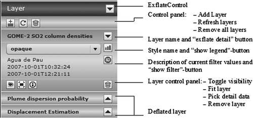
Figure 4. Global time filter control; one can set up the global time filter by selecting the start and end date, and the number of days per tick.
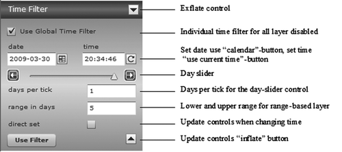
Figure 5. Alert level control also shows its probability. In the next months, we will make it possible to interactively reassess the alert level.
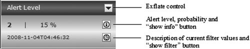
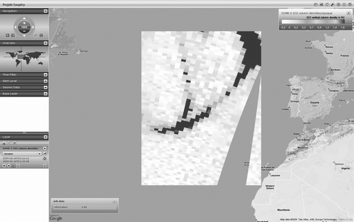
Figure 6. False alarm; GOME-2 satellite image shows a high concentration (dark) of SO2 over the Atlantic Ocean on 26 June 2008.
Note: The SO2 source were not Azores, it was Sarychev Peak (Kuril Islands, Russia) whose eruption started on 12 June 2009. The SO2 cloud reached Europe after crossing the Pacific Ocean and North America. The gap in the layer area is the consequence of satellite coverage – the image consists of two tracks and the gap was not covered by the GOME-2 on that day.