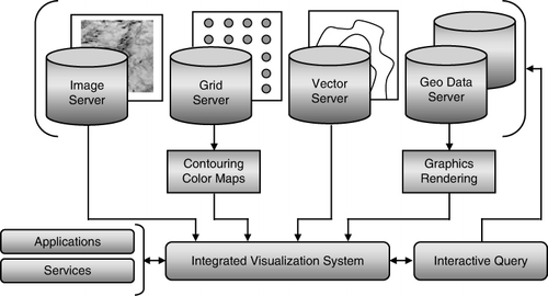
Figures & data
![Figure 2. Satellite imagery [Landsat 7, bands 2, 4, and 7, Source: National Aeronautics and Space Administration (NASA)] overlaid with colored contours of topography [30 arc-seconds Shuttle Radar Topography Mission (SRTM30), Source: National Geospatial-Intelligence Agency (NGA) and NASA] and black contours of gravity [Source: Pakistan Geophysical Database]. A sedimentary basin was demarcated with an orange line by identifying the zone of low gravity.](/cms/asset/ba7037c3-e965-46c4-837c-c1f1d6f415e8/tjde_a_638990_f0002_oc.jpg)
![Figure 3. Satellite Imagery [Landsat 7, bands 2, 4, and 7, Source: National Aeronautics and Space Administration (NASA)] with three exploration data layers; lease concessions polygons, seismic lines (yellow lines with purple pickets) and wells (red circles) [Source: Pakistan Exploration Database]. A 3D seismic survey grid was planned in the lower-left area using interactive seismic survey design tools.](/cms/asset/184363c5-6abb-4c72-8e7a-9b5545ce345c/tjde_a_638990_f0003_oc.jpg)
![Figure 4. Shaded relief map generated from Digital Elevation Model [3 arc-seconds Shuttle Radar Topography Mission (SRTM3), Source: National Geospatial-Intelligence Agency (NGA) and National Aeronautics and Space Administration (NASA)] overlaid with structural faults (pink lines) [Source: Pakistan Geophysical Database], earthquake epicenters (green, blue, and red dots) [Source: National Earthquake Information Center (NEIC), US Geological Survey] and administrative boundaries of Pakistan (yellow). A seismic hazard zones map was generated by analyzing the faults and earthquakes patterns. It highlights four seismic risk zones; minor (green), minor to moderate (blue), moderate (orange) and severe (red).](/cms/asset/fb6b8f0d-4017-49e1-988e-60db4828cb4f/tjde_a_638990_f0004_oc.jpg)
![Figure 5. (Upper-left) Colored topographic map with administrative boundaries of Pakistan (yellow). (Lower-right) The same map with rivers and a superimposed partially transparent image of drainage pattern, computed from Digital Elevation Model [3 arc-seconds Shuttle Radar Topography Mission (SRTM3), Source: National Geospatial-Intelligence Agency (NGA) and National Aeronautics and Space Administration (NASA)].](/cms/asset/bdb6c960-d3cb-4b14-802d-8c0868801604/tjde_a_638990_f0005_oc.jpg)
Please note: Selecting permissions does not provide access to the full text of the article, please see our help page How do I view content?
To request a reprint or corporate permissions for this article, please click on the relevant link below:
Please note: Selecting permissions does not provide access to the full text of the article, please see our help page How do I view content?
Obtain permissions instantly via Rightslink by clicking on the button below:
If you are unable to obtain permissions via Rightslink, please complete and submit this Permissions form. For more information, please visit our Permissions help page.