1,379
Views
48
CrossRef citations to date
0
Altmetric
Original Articles

Land-surface temperature retrieval at high spatial and temporal resolutions based on multi-sensor fusion

, , &
Pages 113-133 | Received 14 Sep 2012, Accepted 04 Mar 2013, Published online: 10 Apr 2013

Figures & data

Figure 1. The actual and predicted LSTs. (a), (b), and (c) are the actual MODIS LST on 11 November 2001, 29 December 2001, and 15 February 2002, respectively. (d), (e), and (f) are the actual ETM + LST on 11 November 2001, 29 December 2001, and 15 February 2002, respectively. (g), (h), and (i) are the actual ETM + LST, but colored corresponding to (d), (e), and (f), respectively. (j), (k), and (l) are the predictions using one input date pair of November 11 as the base data, two input date pairs of November 11 and February 15 as the base data, and one input date pair of February 15 as the base data, respectively.
Figure 2. Comparisons between actual and predicted LSTs. (a), (b), and (c) are predicted LSTs at 29 December 2001, by STARFM, using the data from 11 November 2001; the data from 11 November 2001, and 15 February 2002; and the data from 15 February 2002, respectively, from left to right. (d), (e), and (f) are predicted LSTs on 29 December 2001, by the proposed method using the same data as the upper row. (g) is the actual LST on 29 December 2001.
Figure 3. Comparisons between the actual LST and the predicted LST using scatter plots by STARFM (a), scatter plots by the proposed method (b), and a histogram of the predicted minus observed LST for each method (c), respectively.

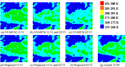
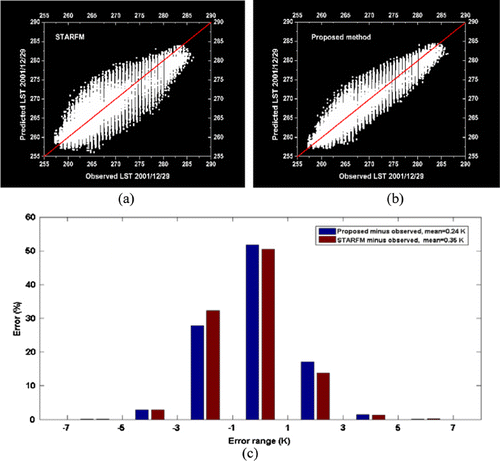
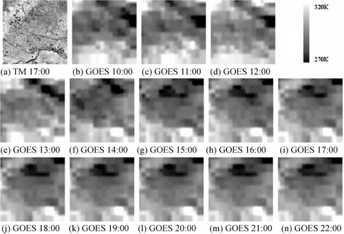
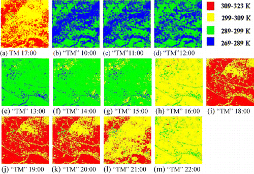
Table 1. AAD and RMSE between the predictions from different input data and actual LST of the first series of experiments.

Figure 4. The actual Landsat and MODIS LST. (a), (b), and (c) are the MODIS LSTs on July 9, October 13, and November 30, 2002, respectively. (d), (e), and (f) are the Landsat TM LSTs on July 9, October 13, and November 30, 2002, respectively.
Figure 5. Comparisons between the actual and predicted LSTs (colored). (a), (b), and (c) are the predicted LSTs on October 13 by STARFM using the data from July 9, the data from November 30, and the data from July 9 and November 30, respectively, from left to right. (d), (e), and (f) are the predicted LSTs on October 13 by the proposed method using the same data as the upper row. (g) is the actual LST on October 13 (the change is in the range of 290–310 K).
Figure 6. Scatter plots of predicted LSTs using the proposed method against actual LST for the different input data pairs. (a) is the scatter plot of the predicted LST using the one input data pair from July 9 against the actual LST. (b) is the scatter plot of the predicted LST using the one input data pair from November 30 against the actual LST. (c) is the scatter plot of the predicted LST using the two input data pairs from July 9 and November 30 against the actual LST.

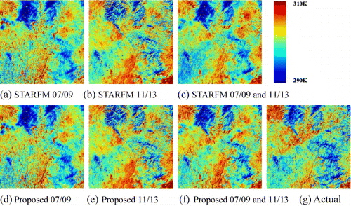
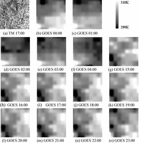
Table 2. AAD and RMSE between the predictions from different input data and actual LST of the second series of experiments.

Figure 7. The actual Landsat LST and GOES LST. (a) is the Landsat LST observed on 4 September 2010; and (b)–(n) are the GOES LSTs observed between 10:00 and 22:00 UTC time during 4 September 2010.
Figure 8. Comparisons between the actual TM and predicted LST (colored). (a) is the actual Landsat TM LST (colored), and (b)–(n) are the predictions (colored) at Landsat spatial resolution (‘TM’) between 10:00 and 22:00 UTC time on 4 September 2010, respectively.
Figure 9. The average LST of between 10:00 and 22:00 UTC time on 4 September 2010.
Figure 9. The average LST of Figure 8 between 10:00 and 22:00 UTC time on 4 September 2010.
Figure 10. The actual Landsat LST and GOES LST. (a) is the Landsat LST observed on 18 June 2010, and (b)–(o) are the GOES LSTs observed between 00:00 and 04:00 UTC time and 15:00 to 23:00 UTC time on 18 June 2010, respectively.
Figure 11. Comparisons between the actual TM and predicted LST (colored). (a) is the actual Landsat LST at 17:00 UTC time (colored), and (b)–(n) are the predictions (colored) at Landsat TM spatial resolution (‘TM’) from 00:00 to 04:00 UTC time and 15:00 to 23:00 UTC time on 18 June 2010, respectively.
Figure 12. Evaluation of estimates of LST based on proposed method with the SXF site observations. (a) is the predicted LST (circles in blue) compared directly with the SXF observations (dotted line in red) on 18 June 2010, the solid circle at 17:00 UTC time represents the actual TM LST, the data gaps in GOES from 05:00 to 14:00 UTC time, due to clouds or otherwise reduced visibility, are not predicted, (b) the scatter plot of the predicted LST versus in situ LST.
Figure 13. Evaluation of estimates of LST based on proposed method with the DRA site observations. (a) is the predicted LST (circles in blue) compared directly with the DRA observations (dotted line in red) on 20 August 2002, the solid circle at 18:00 UTC time represents the actual ETM + LST, the data gaps in GOES from 08:30 to 10:00 UTC time, due to the GOES observations being absent, are not predicted, (b) the scatter plot of the predicted LST versus in situ LST.

Reprints and Corporate Permissions

Please note: Selecting permissions does not provide access to the full text of the article, please see our help page How do I view content?

To request a reprint or corporate permissions for this article, please click on the relevant link below:

Academic Permissions

Please note: Selecting permissions does not provide access to the full text of the article, please see our help page How do I view content?

Obtain permissions instantly via Rightslink by clicking on the button below:

If you are unable to obtain permissions via Rightslink, please complete and submit this Permissions form. For more information, please visit our Permissions help page.