2,561
Views
17
CrossRef citations to date
0
Altmetric
Original Articles

Using remote sensing to assess impacts of land management policies in the Ordos rangelands in China

, &
Pages 81-102 | Received 02 Dec 2012, Accepted 11 Jul 2013, Published online: 05 Sep 2013

Figures & data

Figure 1. Location of the study area and distribution of the meteorological stations. The basic administrative unit shown in this figure in Inner Mongolia is Banner, which is similar to the unit “County” in other provinces. The location of meteorological stations are marked by a circle.

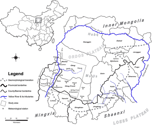
Table 1. Multi-temporal satellite images used in this study.

Table 2. Overall accuracy of each individual classification.

Table 3. Features of the selected sites.

Figure 2. NDVI trajectories and annual rainfall. Note: (a) and (a′) for Site A; (b) and (b′) for Site B; (c) and (c′) for Site C; (d) and (d′) for site D; (e) and (e′) for Site E, and (f) and (f′) for Site F.
Figure 3. Rangeland biophysical changes in the study area in the period 1978-2007. Note: The figure shows (1) vegetation vigor growth (VGT-G), and (2) vegetation degradation (VGT-D). Sites A, B, C, D, E and F were selected to calibrate the relationship between biophysical feature changes (e.g. NDVI) and rainfall variation.

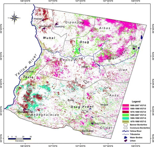
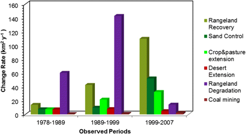
Table 4. Land cover changes in the study area.

Figure 4. Land cover change rates in the observed policy implementation periods.
Figure 5. Specific land use/cover changes in the study area.

Reprints and Corporate Permissions

Please note: Selecting permissions does not provide access to the full text of the article, please see our help page How do I view content?

To request a reprint or corporate permissions for this article, please click on the relevant link below:

Academic Permissions

Please note: Selecting permissions does not provide access to the full text of the article, please see our help page How do I view content?

Obtain permissions instantly via Rightslink by clicking on the button below:

If you are unable to obtain permissions via Rightslink, please complete and submit this Permissions form. For more information, please visit our Permissions help page.