1,313
Views
25
CrossRef citations to date
0
Altmetric
Original Articles

An integrated geospatial information service system for disaster management in China

, , , , , & show all
Pages 918-945 | Received 20 Mar 2014, Accepted 01 Aug 2014, Published online: 08 Sep 2014

Figures & data

Figure 1. Data-centric disaster management mode.
Figure 2. The principles of the FSM.
Figure 3. The task-oriented FSM of the IDISS.

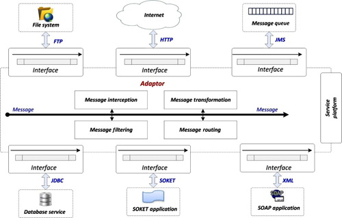
Table 1. Services and interfaces used in the IDISS.

Figure 4. System architecture of the IDISS.
Figure 5. The basic implementation architecture of the IDISS resource layer.

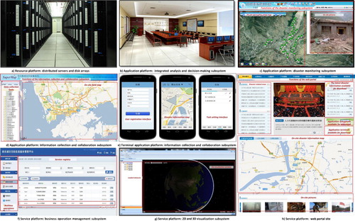
Table 2. Hardware resources of the IDISS.

Figure 6. The overall architecture of the IDISS service layer.
Figure 7. Flow chart of the business processes of the IDISS.
Figure 8. Service integration and management modules of the IDISS.
Figure 9. The unified adaptor structure of the IDISS.
Figure 10. System deployment at the national and provincial disaster reduction centers.
Figure 11. Use case diagram of the IDISS for multiple users from national and provincial disaster reduction centers and on-site users.
Figure 12. Subsystems and platforms included in the constructed IDISS in the NDRCC.
Figure 13. Pictures of integrated spatial information service products for disaster reduction.

Reprints and Corporate Permissions

Please note: Selecting permissions does not provide access to the full text of the article, please see our help page How do I view content?

To request a reprint or corporate permissions for this article, please click on the relevant link below:

Academic Permissions

Please note: Selecting permissions does not provide access to the full text of the article, please see our help page How do I view content?

Obtain permissions instantly via Rightslink by clicking on the button below:

If you are unable to obtain permissions via Rightslink, please complete and submit this Permissions form. For more information, please visit our Permissions help page.