903
Views
14
CrossRef citations to date
0
Altmetric
Original Articles

A geospatial search engine for discovering multi-format geospatial data across the web

, , &
Pages 47-62 | Received 05 Mar 2014, Accepted 11 Sep 2014, Published online: 24 Oct 2014

Figures & data

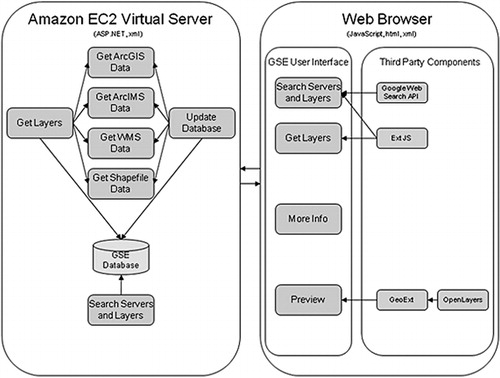
Figure 1. GSE design showing the respective functionality of the web interface and the Amazon EC2 server. The system combines JavaScript and HTML inside a browser (right panel) with an ASP.NET application on a virtual web server (left panel).
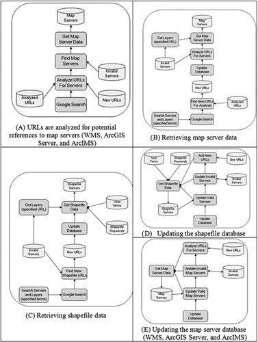
Figure 2. System design for analyzing URLs, retrieving server data, and updating the database within the GSE. (A) URLs are analyzed for potential references to map servers (WMS, ArcGIS Server, and ArcIMS; (B) Map server data is retrieved; (C) Retrieving information on shapefiles; (D) Updating the shapefile database; (E) Updating the map server database (WMS, ArcGIS Server, and ArcIMS).
Figure 3. Global spatial extent of the number of WMSs discovered by the GSE.
Figure 4. Map viewer of the GSE user interface displaying data selected from the Global Risk Data Platform server.
Figure 5. Map viewer of the GSE user interface displaying fire location data selected from the State of California’s Natural Resource Agency.

Reprints and Corporate Permissions

Please note: Selecting permissions does not provide access to the full text of the article, please see our help page How do I view content?

To request a reprint or corporate permissions for this article, please click on the relevant link below:

Academic Permissions

Please note: Selecting permissions does not provide access to the full text of the article, please see our help page How do I view content?

Obtain permissions instantly via Rightslink by clicking on the button below:

If you are unable to obtain permissions via Rightslink, please complete and submit this Permissions form. For more information, please visit our Permissions help page.