Figures & data
Figure 1. Sample illustration of days used in compositing the MODIS MYD13Q1 NDVI product from the 27 April 2008 (day 116) 16-day composite. The top figure shows the VZAs associated with the days used. The lower figure shows the day within the period that was used in the composite. The MOD13 product uses a minimum VZA as part of the quality selection, but nonetheless some large angles are used as a result of coincident factors such as persistent cloud contamination.
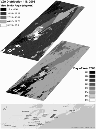
Table 1. EOS validation sites and landsat 5 TM data used in the study.
Figure 2. Distributions of the source Landsat albedo for each season at increasing spatial scales (250–2000 m) centered around the site.
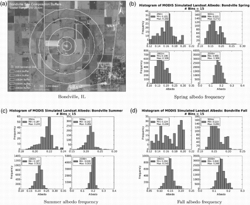
Figure 3. Histograms of albedo frequency for the different seasons and scales for the Harvard Forest site.
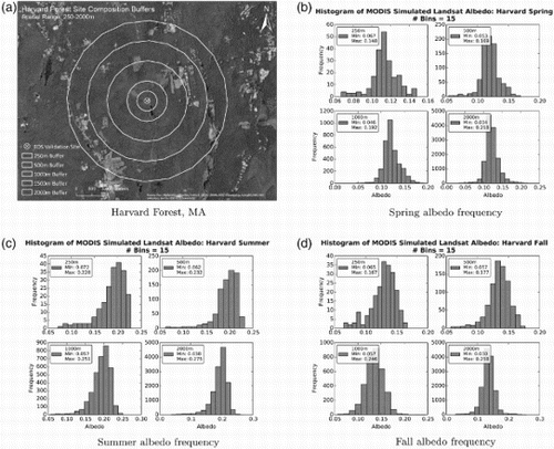
Figure 4. Histograms of albedo frequency for the different seasons and scales for the Konza Prairie site.
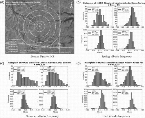
Figure 5. (a) for Lake Tahoe illustrates the composition of pixels at coarser resolutions and the level of land features that are added to the signal. The relative homogeneity of the Jornada site can be seen in (c).
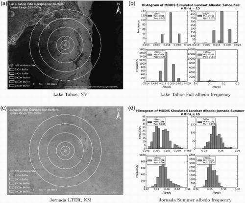
Figure 6. The spatial relationship between 1 km geolocation data and the 500 and 250 m resolutions. The cell center of the 1 km data is co-registered with the second and fourth 500 and 250 m pixels, respectively. An accurate geolocation for each of the resolutions can be determined though bilinear interpolation of the 1 km values. (This figure is derived from Nishihama et al. (Citation1997, ).)
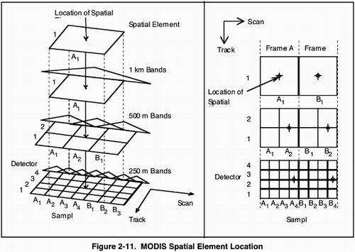
Figure 7. Illustration of swath observation simulation. Landsat pixels are assigned weights from a 5 × 9 grid centered inside the swath pixel and incorporating signal from neighboring pixels. The value for a given pixel is then the weighted average of all Landsat pixels. The simulated swath observation is consistent with the LSF of the MODIS instrument.
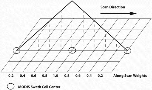
Table 2. MOD/MYD03 time periods used for simulating data.
Figure 8. The full process of synthesizing data. Clockwise from top left: (a) The original Landsat synthetic albedo at 30 m resolution. (b) The next step transforms the Landsat at 30 m resolution to daily MODIS observation geometry derived from daily MOD03 geolocation data and projected to a geographic coordinate system preserving the variable swath pixel sizes. This example uses data from Aqua and has a VZA of 26.47°, resulting in an pixel. (c) Finally, the daily synthetic swath data are gridded to the MODIS sinusoidal grid at 250 m resolution.
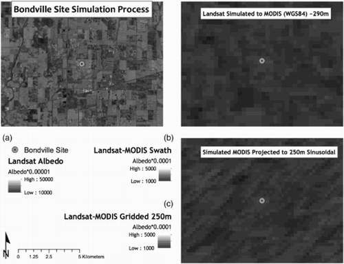
Figure 9. Simulated swath pixel albedo plotted as a function of VZA for Harvard Forest site. The results show the largest values are observed in the mid-range of VZAs between ≈ 15° and 35°. Overall variability for these simulated swath data appears low, reporting a measured standard deviation of 0.009. The range of values is larger at 0.038, which is a significant contribution to uncertainty from the variable GSD before gridding occurs.
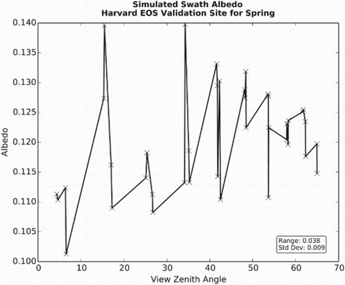
Figure 10. Albedo ranges and standard deviation for all sites. The plot is arranged in ascending order of increasing pixel size from 250 to 2000 m, illustrating the albedo variability for the three seasons tested.
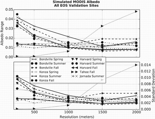
Figure 11. Albedo ranges (upper figure) and standard deviation (lower figure) for the Bondville site. The results for Bondville indicate a resolution of at least 1000 m to stabilize the effect from geometric distortion, though it is not fully removed even at 2000 m.
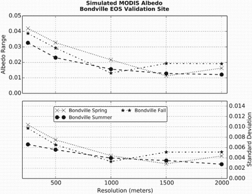
Figure 12. Discrete eight-day groups of simulated albedo for the Bondville site.
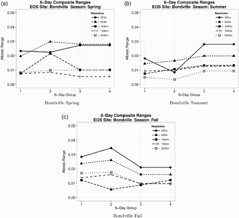
Figure 13. Range (upper plot) and standard deviation (lower plot) for the Harvard Forest site. The albedo data for Harvard Forest demonstrate a continuing reduction of error as pixel size increases.
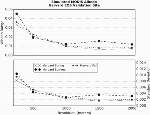
Figure 14. Discrete 8-day groups of simulated albedo for the Harvard site.
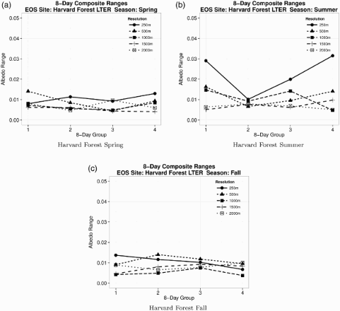
Figure 15. Albedo ranges and standard deviation for the Konza Prairie site. The relatively homogeneous land cover at the Konza Prairie site demonstrates an overall small and consistent uncertainty for all resolutions.
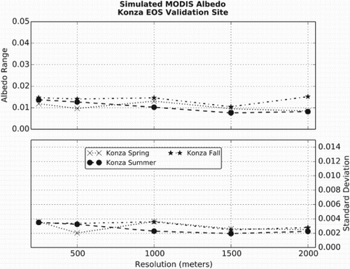
Figure 16. Discrete 8-day groups of simulated albedo for the Konza site.
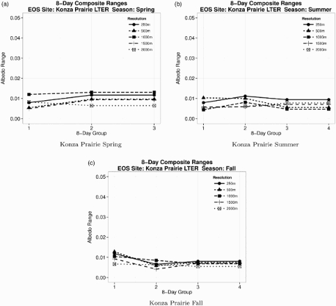
Figure 17. Albedo ranges and standard deviation for the Lake Tahoe and Jornada sites. The actual site center for Lake Tahoe is located offshore, but inclusion of signal from land features is steadily introduced at increasing spatial resolutions increasing the variability in the signal. The Jornada data present a stable level of uncertainty for all resolutions.
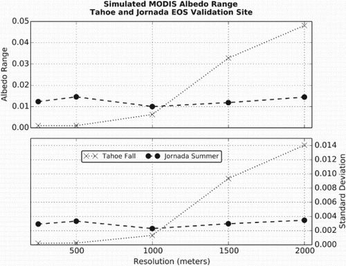
Figure 18. Discrete 8-day groups of simulated albedo for the Lake Tahoe and Jornada sites.
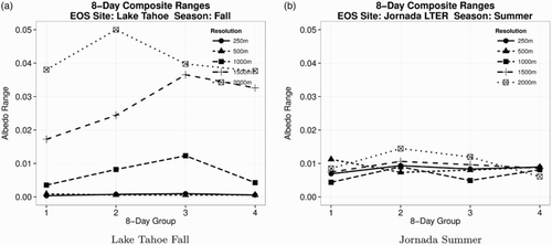
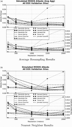
Figure 19. Albedo profiles for all sites using an average resampling method for all resolutions (a). All sites except for Lake Tahoe demonstrate a reduction in range and standard deviations at fine resolutions when compared to the nearest neighbor resampling (b). The average resampling method presents a more consistent and smaller error at a finer resolution.