
Figures & data
Table 1. SEVIRI ET satellite observations utilized in this study and their main characteristics.
Table 2. Classification of drought severity based on ESI value.
Figure 1. Monthly water stress workflow implemented in VLab.
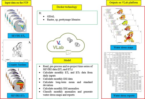
Figure 2. Representative time series maps of water stress levels generated in VLab for the month of July across Europe in 2011 (a), 2012 (b), 2013 (c), 2014 (d), 2015 (e), 2016 (f), 2017 (g), 2018 (h), 2019 (i) and 2020 (j).
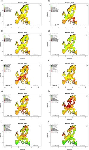
Table 3. A representative example (July 2018) of text report (table) output file at the national level generated from the monthly water stress model executed in VLab platform.
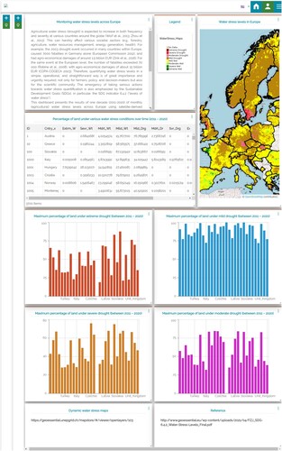
Figure 3. Created a dashboard (a snapshot) for monthly water stress levels at the European scale. For more information, the reader is referred to the interactive dashboard at (https://geoessential.unepgrid.ch/mapstore/#/dashboard/105/; last access: 23 February 2022).
Data availability statement
All the needed inputs data that support the findings of this study are published and openly available through Zenodo repository (https://doi.org/10.5281/zenodo.6239078; last access: 23 February 2022). Moreover, the complete data is available and can be accessed through the EUMETSAT Satellite Application Facility on Land Surface Analysis (LSA SAF) database (https://landsaf.ipma.pt/en/data/; last access: 23 February 2022).