
Figures & data
Figure 1. Spatial distribution of POIs from three selected geographic regions (a) South Africa (b) Facebook (c) 4square (d) Here (e) OSM (f) Google (g) TomTom (h) Vkonta (i) Wikimap (j) South Korea (k) England.
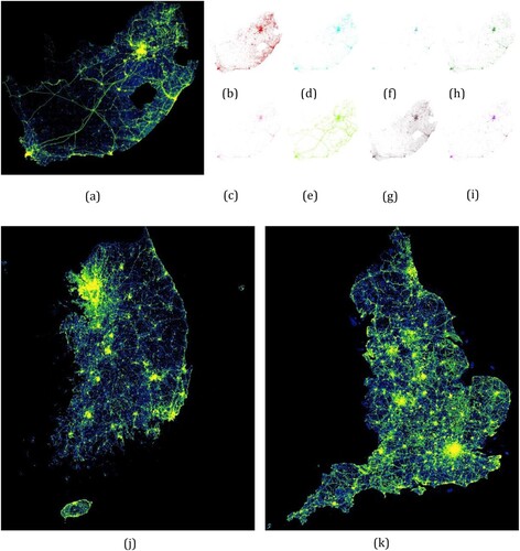
Figure 2. Framework for AOI embedding learning based on POI.
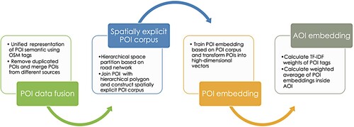
Table 1. Example semantic translation from POI category to OSM tags.
Figure 3. Hierarchical space partition of three study regions.
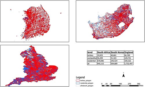
Table 2. Hierarchical space partition-based road network.
Table 3. Spatially explicit POI embedding results for different geographic regions.
Table 4. Grouping of OSM land use classes (13 classes to 3 classes).
Table 5. F-score of three-class land use classification models.
Figure 4. Confusion matrix for 13-class classification models (a) South Africa (b) South Korea (c) England.
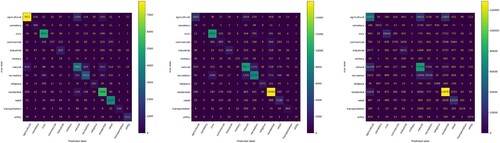
Table 6. Classification performance of land use classes of 13-class model.
Table A1. Grouping of OSM land use classes.
Data availability statement
The data that support the findings of this study are available from PlanetSense project. Restrictions apply to the availability of these data, which were used under license for this study. Data are available from the authors with the permission of PlanetSense project (https://planetsense.ornl.gov/webps/). The OSM data used in this study can be openly accessed at https://www.openstreetmap.org/export.