
Figures & data
Figure 1. Region of interest.
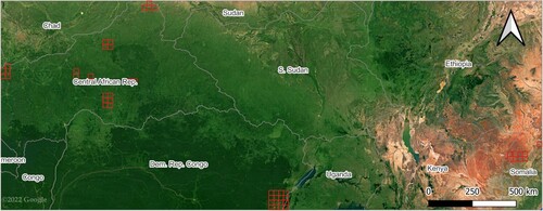
Figure 2. Illustration of the derivation of the Map Of Land Cover Agreement – MOLCA.
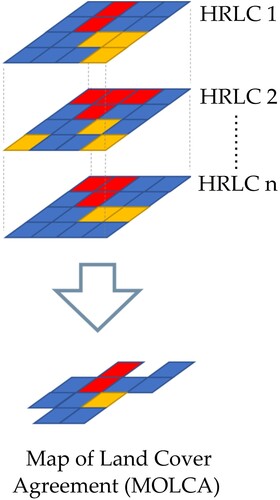
Figure 3. Overview of MOLCA production workflow.
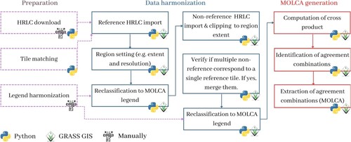
Table 1. OA of land cover products with different validation datasets.
Table 2. Accuracy of Sentinel-2 allB product with all samples.
Table 3. Accuracy of Sentinel-2 allB product with hard-to-classify samples.
Table 4. Accuracy of Sentinel-2 allB product with easy-to-classify samples.
Figure 4. Land cover map obtained in Sentinel-2 allB classification test.
Table 5. Comparison of the accuracy of World Cover, Dynamic World and Esri land cover with the accuracy of Sentinel-2 allB product.
Data availability statement
The datasets that support this study are freely available land cover datasets such as: FROM-GLC (http://data.ess.tsinghua.edu.cn/fromglc2017v1.html), GL30 (http://www.globallandcover.com/), CCI Africa Prototype (https://2016africalandcover20m.esrin.esa.int/), GHS BU S1NODSM (http://cidportal.jrc.ec.europa.eu/ftp/jrc-opendata/GHSL/GHS_BUILT_S1NODSM_GLOBE_R2018A/), WSF (https://download.geoservice.dlr.de/WSF2019/files/), GSW (https://global-surface-water.appspot.com/download), and FNF (https://www.eorc.jaxa.jp/ALOS/en/palsar_fnf/data/index.htm). GL30 and FNF require registration in order to retrieve the data, while CCI Africa Prototype require acceptance of terms of use. Satellite imagery, Planet NICFI Basemap (https://developers.google.com/earth-engine/datasets/catalog/projects_planet-nicfi_assets_basemaps_africa?hl=en) and Sentinel-2 (https://developers.google.com/earth-engine/datasets/catalog/COPERNICUS_S2), as well as CGIAR-CSI SRTM DEM (https://developers.google.com/earth-engine/datasets/catalog/CGIAR_SRTM90_V4), World Cover (https://developers.google.com/earth-engine/datasets/catalog/ESA_WorldCover_v100), Dynamic World (https://developers.google.com/earth-engine/datasets/catalog/GOOGLE_DYNAMICWORLD_V1) were obtained from Earth Engine Data Catalog. Esri land cover is directly accessible on Google Earth Engine through ‘awesome-gee-community-catalog’ by using ID projects/sat-io/open-datasets/landcover/ESRIGlobal-LULC
10m
TS. ‘awesome-gee-community-catalog’ is a collection of geospatial datasets contributed by the community. MOLCA, which is the first dataset obtained by the methodology reported in this paper, is freely and openly available at https://doi.org/10.5281/zenodo.8071675.