2,039
Views
10
CrossRef citations to date
0
Altmetric
Grubb Review

Patterns of variation among forests of tropical Asian mountains, with some explanatory hypotheses

Pages 361-377 | Received 24 Sep 2015, Accepted 14 Jan 2018, Published online: 09 Apr 2018

Figures & data

Table 1. The global characteristics of forest zones by elevation in the equatorial and oceanic tropics, as observed in Asia (after Whitmore Citation1984; Ashton Citation2014).

Figure 1. The five immigration tracks of the Tropical Asian flowering plant flora, numbered in large font size: 1, tropical, from the late Cretaceous/Paleocene from North America and Europe; 2, tropical, from the late Cretaceous into Indian Gondwana, and from thence to the Far East from the late Eocene; 3, warm temperate, at first from North America via Europe, but mostly probably from the lower Miocene and East Asia; 4, initially warm temperate, from the lower Miocene, Australasia; 5, tropical arid, from the mid-Miocene, Africa through the middle East. Tracks 2, 3 and 4 make the major contributions to the mountain flora. Place names that are referred to in the text are numbered by in small font size individual localities with black numbering and indicated with a dot, wider areas with blue numbering:

1, Thar Desert; 2, Mt. Abu; 3, Arravalli Range; 4, Western Ghats; 5, Mahableshwar Plateau; 6, Goa; 7, Mt. Nilgiries; 8, Deccan Plateau; 9, Mt. Pachmarhi; 10, Eastern Ghats; 11, Sri Lanka; 12, Mt. Knuckles; 13, Adam’s Peak; 14, Horton Plains; 15, Bengal Bay; 16, Andaman Islands; 17, Himalayas; 18, Ganges Valley; 19, Nepal; 20, Mt. Similipal; 21, Mt. Parasnath; 22, Tibet; 23, Bhutan; 24, Khasi Hills; 25, Meghalaya; 26, Mt. Victoria; 27, Chin Hills; 28, Sandoway; 29, Burma (Myanmar); 30, Indo-Burma; 31, Mt. Doi Chang Dao; 32, Mt. Doi Inthanon; 33, Yunnan; 34, Mt. Kao Yai; 35, Thailand; 36, Mt. Kamchay; 37, Cambodia; 38, Laos; 39, Annamite Range; 40, Vietnam; 41, Mt. Phu Bea; 41, Western Ghats; 42, Hainan; 43, Guangxi; 44, Qin Ling Shan; 45, Honshu; 46, Kangar; 47, Pattani; 48, Peninsular Malaysia; 49, Sumatra; 50, Sundalands; 51, Mt. Santubong; 52, Borneo; 53, Brunei; 54, Mt. Kinabalu; 55, Mt. Silam; 56, Luzon; 57, Philippines; 58, Makassar Strait; 59, Sulawesi; 60, Bali; 61, Lesser Sunda Islands; 62, Timor; 63, New Guinea; 64, Mt. Trikora; 65, Mt. Hagen; 66, Mt. Wilhelm; 67, Mt. Kerigomna; 68, Australasia; 69, Louisiades Archipelago.

Figure 1. The five immigration tracks of the Tropical Asian flowering plant flora, numbered in large font size: 1, tropical, from the late Cretaceous/Paleocene from North America and Europe; 2, tropical, from the late Cretaceous into Indian Gondwana, and from thence to the Far East from the late Eocene; 3, warm temperate, at first from North America via Europe, but mostly probably from the lower Miocene and East Asia; 4, initially warm temperate, from the lower Miocene, Australasia; 5, tropical arid, from the mid-Miocene, Africa through the middle East. Tracks 2, 3 and 4 make the major contributions to the mountain flora. Place names that are referred to in the text are numbered by in small font size individual localities with black numbering and indicated with a dot, wider areas with blue numbering:1, Thar Desert; 2, Mt. Abu; 3, Arravalli Range; 4, Western Ghats; 5, Mahableshwar Plateau; 6, Goa; 7, Mt. Nilgiries; 8, Deccan Plateau; 9, Mt. Pachmarhi; 10, Eastern Ghats; 11, Sri Lanka; 12, Mt. Knuckles; 13, Adam’s Peak; 14, Horton Plains; 15, Bengal Bay; 16, Andaman Islands; 17, Himalayas; 18, Ganges Valley; 19, Nepal; 20, Mt. Similipal; 21, Mt. Parasnath; 22, Tibet; 23, Bhutan; 24, Khasi Hills; 25, Meghalaya; 26, Mt. Victoria; 27, Chin Hills; 28, Sandoway; 29, Burma (Myanmar); 30, Indo-Burma; 31, Mt. Doi Chang Dao; 32, Mt. Doi Inthanon; 33, Yunnan; 34, Mt. Kao Yai; 35, Thailand; 36, Mt. Kamchay; 37, Cambodia; 38, Laos; 39, Annamite Range; 40, Vietnam; 41, Mt. Phu Bea; 41, Western Ghats; 42, Hainan; 43, Guangxi; 44, Qin Ling Shan; 45, Honshu; 46, Kangar; 47, Pattani; 48, Peninsular Malaysia; 49, Sumatra; 50, Sundalands; 51, Mt. Santubong; 52, Borneo; 53, Brunei; 54, Mt. Kinabalu; 55, Mt. Silam; 56, Luzon; 57, Philippines; 58, Makassar Strait; 59, Sulawesi; 60, Bali; 61, Lesser Sunda Islands; 62, Timor; 63, New Guinea; 64, Mt. Trikora; 65, Mt. Hagen; 66, Mt. Wilhelm; 67, Mt. Kerigomna; 68, Australasia; 69, Louisiades Archipelago.

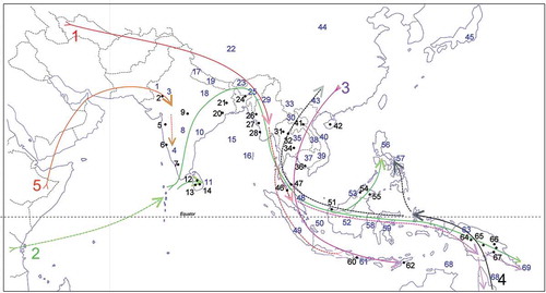
Table 2. Summary of elevational zonal changes in climate, soils and forests in the humid tropics. The motor to habitat change with elevation is temperature decline, ca. 6.5 K km-1 ascent on tropical mountains, and its interaction with atmospheric humidity to produce cloud (fog) and consequent precipitation. These factors of climate, with substrate, determine soil formation in interaction with forest cover and litter production. Absence or presence of cloud/fog seasonality results in differing soil and forest zonation, indicated in the paired columns. Temperatures are mean monthly values.

Reprints and Corporate Permissions

Please note: Selecting permissions does not provide access to the full text of the article, please see our help page How do I view content?

To request a reprint or corporate permissions for this article, please click on the relevant link below:

Academic Permissions

Please note: Selecting permissions does not provide access to the full text of the article, please see our help page How do I view content?

Obtain permissions instantly via Rightslink by clicking on the button below:

If you are unable to obtain permissions via Rightslink, please complete and submit this Permissions form. For more information, please visit our Permissions help page.