Figures & data
Figure 1. Schematic cross-section of a bog remnant with surrounding drylands and indicating the stratigraphical distinction between supra-peat, intra-peat, and sub-peat layers. The three layers harbour different types of cultural remains (cf. Gearey et al. Citation2010). Mineral soils represented in light grey, peat soils in black.
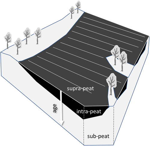
Table 1. Simplified overview of common cultural remain types (with examples) in (former) bog landscapes classified according to bog use stage and stratigraphical position (on land surface, within, or underneath peat deposit). This article focuses on visible tangible remains at the land surface (intangible remains indicated in italic).
Figure 2. Map of the Netherlands indicating (a) bog distribution around 1500 CE and (b) the 17 Natura 2000 areas with bog remnants. The three case study areas of this paper are indicated with rectangles. The numbers correspond with those in Appendix 2. Peat distribution map adapted by permission from Springer Nature: Springer, climatological, stratigraphic and palaeo-ecological aspects of mire development, W. A. Casparie & J. G. Streefkerk, copyright 1992 (https://doi.org/10.1007/978-94-015-7997-1_3).
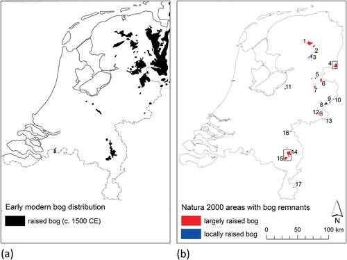
Figure 3. Procedure to identify tangible bog-related cultural remains on the surface of bog remnants and surrounding reclamation landscapes.
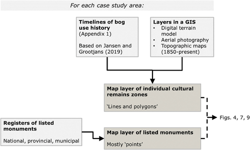
Table 2. Potential synergies between key ecological management measures and heritage management in raised bogs, with accompanying caveats, as summarised from Appendix 3.
Figure 4. Map of the Bargerveen case study area showing the spatial pattern of supra-peat tangible cultural remains zones relating to specific historical land use forms, and the location of listed national, provincial, and municipal monuments linked to these land use forms. LSPR = large-scale planned reclamation; LSC = large-scale commercial peat extraction.
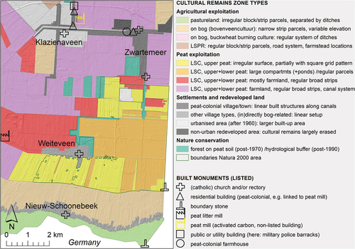
Figure 5. St Antony’s church with rectory (built in 1921). In the foreground the former edge of the Bargerveen where turves are being dried. Later these buildings were designated as national monuments partly because of their special location on the edge of the peat-colonial village of Zwartemeer and close to the present-day Bargerveen nature reserve. Photo: J.B. Schröer, Drents Archief (collectie Schröer).
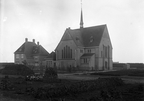
Figure 6. Upper image: former peasant house in a recently rewetted part of the Bargerveen nature reserve. The last residents left in 1967. More recently, the building was adapted to function as a habitat to wild animals, until it burned down after a lightning strike in 2018 (photo by Albert Raven, taken with permission from Raven Citation2015). Lower image: the present situation in the area (taken with permission from Wanders Citation2020).
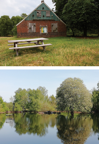
Figure 7. Map of the Peel case study area showing the spatial pattern of supra-peat tangible cultural remains zones relating to specific historical land use forms, and the location of listed national and municipal monuments linked to these land use forms. (LSP)R = (large-scale planned) reclamation of former bog and heathland; S = subsistence peat extraction; LSC = large-scale commercial peat extraction. The medieval villages of Deurne, Liessel, and Meijel are situated on mineral soil drylands (light grey area).
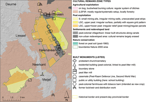
Figure 8. Prominent bog-related cultural remains visible on digital terrain models (DTM) of sites in the Verheven Peel (a-c) and Groote Peel (d) nature reserves. The location of the more detailed DTM images a-c is indicated on the top left overview image. Background DTM images courtesy of AHN viewer (https://www.ahn.nl/ahn-viewer), CC0.
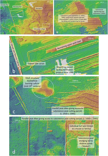
Figure 9. Upper image: map of the Korenburgerveen case study area showing the bog’s position in a natural depression (indicated by DTM hillshade background), and the spatial pattern of supra-peat tangible cultural remains zones relating to specific historical use forms. S = subsistence peat extraction. Vv = Vragenderveen; Cv = Corlese Veen; Mv = Meddose Veen. The former two subareas are separated by an old municipal border; the latter two by a railway line. Lower image: map excerpt showing the peat dikes of the Vragenderveen subarea and their names (taken with permission from Wanders Citation2020).
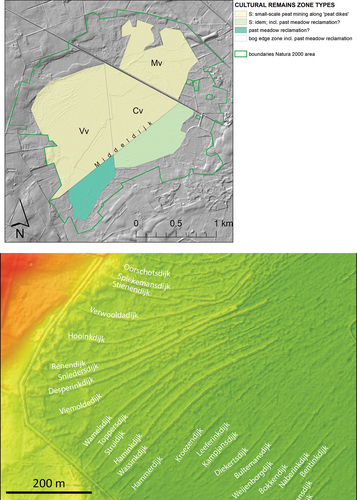
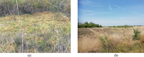
Figure 10. (a) A former peat pit in the Mariapeel bog reserve recolonised by peat moss and other bog plants (courtesy of Hilde Tomassen). (b) An old ditch system is still visible through the linear zones of light-coloured purple moor-grass (Molinia caerulea) (taken with permission from Wanders Citation2020).