Figures & data
Table 1. Described and undescribed xenophyophore species found within the Clarion-Clipperton Zone. N = species found attached to nodules; S = species found on sediment surface. Asterisks indicate species for which genetic data are available. Species names in bold refer to species recorded from outside the CCZ. Note that most species are rare and the absence of such records does not imply that species are endemic to the CCZ. All species are represented by published photographs. A few additional undescribed xenophyophores that were listed in publications [Citation9,Citation27,Citation30] but not illustrated are omitted from the Table
Figure 1. Seafloor images showing xenophyophores, or likely xenophyophores, taken from the ROV using the vertically mounted stills camera (A–C, E) and a forward-facing video camera (D, F–H). (A) Dark spiky sphere (possibly a xenophyophore) next to a branched, segmented tube (possibly a species of the xenophyophore genus Aschemonella); this is most likely a chance juxtaposition. APEI-1: 153.598° W, 11.251° N; 5204 m depth. (B) Dark, upright test with several branches; APEI-7: 141.896° W, 5.114° N; 4855 m depth. (C) Distinctive form comprising radiating branches; APEI-4: 149.939° W, 07.033° N; 5037 m depth. (D) Upstanding mass of branching tubes, possibly either Aschemonella or Rhizammina; APEI-1: 149.940° W, 07.036° N; 5040 m depth. (E) Irregularly-shaped patch with wrinkled surface, possibly a xenophyophore; shadows suggest that parts of the structure are raised above the sediment surface; APEI-4: 149.912° W, 06.990° N; 5003 m depth. Similar patches are common in the vertical images. Note the associated ophiuroid. (F) Test comprising a series of thin, curved plates with clearly-developed ‘growth lines’; APEI-4: 149.911° W, 07.009° N; 5018 m depth. Possibly a well-developed specimen of the recently-described species Psammina tenuis [Citation4]. (G) Oblique view of relatively thick plate with vague ‘growth lines’; APEI-7: 141.816° W, 05.044° N; 4873 m depth. (H) Large plate-like xenophyophore with ‘growth lines’ and root-like structures anchoring it in the sediment; probably Stannophyllum zonarium [Citation4]; APEI-1: 153.606° W, 11.252° N; 5206 m depth. Scale bars = 5 cm. Photo credits: Jennifer Durden and Craig Smith, DeepCCZ Project
![Figure 1. Seafloor images showing xenophyophores, or likely xenophyophores, taken from the ROV using the vertically mounted stills camera (A–C, E) and a forward-facing video camera (D, F–H). (A) Dark spiky sphere (possibly a xenophyophore) next to a branched, segmented tube (possibly a species of the xenophyophore genus Aschemonella); this is most likely a chance juxtaposition. APEI-1: 153.598° W, 11.251° N; 5204 m depth. (B) Dark, upright test with several branches; APEI-7: 141.896° W, 5.114° N; 4855 m depth. (C) Distinctive form comprising radiating branches; APEI-4: 149.939° W, 07.033° N; 5037 m depth. (D) Upstanding mass of branching tubes, possibly either Aschemonella or Rhizammina; APEI-1: 149.940° W, 07.036° N; 5040 m depth. (E) Irregularly-shaped patch with wrinkled surface, possibly a xenophyophore; shadows suggest that parts of the structure are raised above the sediment surface; APEI-4: 149.912° W, 06.990° N; 5003 m depth. Similar patches are common in the vertical images. Note the associated ophiuroid. (F) Test comprising a series of thin, curved plates with clearly-developed ‘growth lines’; APEI-4: 149.911° W, 07.009° N; 5018 m depth. Possibly a well-developed specimen of the recently-described species Psammina tenuis [Citation4]. (G) Oblique view of relatively thick plate with vague ‘growth lines’; APEI-7: 141.816° W, 05.044° N; 4873 m depth. (H) Large plate-like xenophyophore with ‘growth lines’ and root-like structures anchoring it in the sediment; probably Stannophyllum zonarium [Citation4]; APEI-1: 153.606° W, 11.252° N; 5206 m depth. Scale bars = 5 cm. Photo credits: Jennifer Durden and Craig Smith, DeepCCZ Project](/cms/asset/63ec0fb6-146d-4b7f-b483-fa7f74ad88b3/kcib_a_1843818_f0001_oc.jpg)
Figure 2. Seafloor images showing xenophyophores, taken from the ROV using the vertically mounted stills camera. (A) Finely reticulated test; APEI-7: 141.825° W, 05.056° N; 4870 m depth. (B) Reticulated dome, possibly a species of Reticulammina; APEI 7: 141.895° W, 05.114° N; 4855 m depth. (C) Test with thick, reticulated branches; APEI-7: 141.818° W, 05.048° N; 4873 m depth. (D) Dome with poorly-defined reticulations; rather similar to Reticulammina sp. of Gooday et al. (2020) [Citation4]; APEI-1: 153.597° W, 11.251° N; 5204 m depth. (E) Test comprising irregular lamellate branches with a tendency to form reticulations; similar to C but with thinner branches; APEI 7: 141.822° W, 05.054° N; 4872 m depth. (F) Dome comprising thin, fairly densely-reticulated lamellae; APEI 7: 141.819° W, 05.049° N; 4873 m depth. (G) Irregular, coarsely-reticulated dome; APEI-4: 149.941° W, 06.973° N; 5007 m depth. (H) Test comprising reticulated branches or tubes; APEI 4: 149.938° W, 07.031° N; 5035 m depth. Scale bars = 5 cm. Photo credits: Jennifer Durden and Craig Smith, DeepCCZ Project
![Figure 2. Seafloor images showing xenophyophores, taken from the ROV using the vertically mounted stills camera. (A) Finely reticulated test; APEI-7: 141.825° W, 05.056° N; 4870 m depth. (B) Reticulated dome, possibly a species of Reticulammina; APEI 7: 141.895° W, 05.114° N; 4855 m depth. (C) Test with thick, reticulated branches; APEI-7: 141.818° W, 05.048° N; 4873 m depth. (D) Dome with poorly-defined reticulations; rather similar to Reticulammina sp. of Gooday et al. (2020) [Citation4]; APEI-1: 153.597° W, 11.251° N; 5204 m depth. (E) Test comprising irregular lamellate branches with a tendency to form reticulations; similar to C but with thinner branches; APEI 7: 141.822° W, 05.054° N; 4872 m depth. (F) Dome comprising thin, fairly densely-reticulated lamellae; APEI 7: 141.819° W, 05.049° N; 4873 m depth. (G) Irregular, coarsely-reticulated dome; APEI-4: 149.941° W, 06.973° N; 5007 m depth. (H) Test comprising reticulated branches or tubes; APEI 4: 149.938° W, 07.031° N; 5035 m depth. Scale bars = 5 cm. Photo credits: Jennifer Durden and Craig Smith, DeepCCZ Project](/cms/asset/5286ad84-4683-4fad-aaac-888a3c12dfe0/kcib_a_1843818_f0002_oc.jpg)
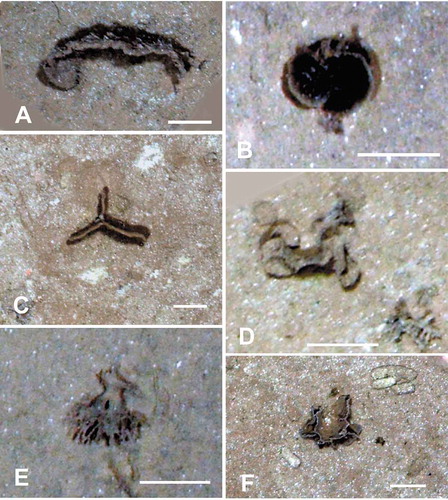
Figure 3. Seafloor images showing xenophyophores, taken from the ROV using the vertically mounted stills camera. (A) Curved plate embedded in the sediment; APEI 4: 149.912° W, 06.992° N; 5006 m depth. (B) Paired pale-rimmed plates; shadows indicate that these are raised above the sediment surface; APEI-1: 153.591° W, 11.251° N; 5200 m depth. (C) Vertically-orientated, triradiate plate, partly embedded in the sediment; APEI 7: 141.895° W, 05.114° N; 4855 m depth. (D) Test comprising rounded, plate-like elements; APEI 4: 149.938° W, 07.030° N; 5034 m depth. (E) Test with thick branched stem, dividing into narrower branches. Possibly disturbed from an originally upright position; APEI-1: 153.591° W, 11.251° N; 5199 m depth. (F) Thin ridge with side-branches arising from horizontal plate; APEI 7: 141.830° W, 05.059° N; 4868 m depth. Scale bars = 5 cm. Photo credits: Jennifer Durden and Craig Smith, DeepCCZ Project