Figures & data
FIGURE 1 Annual landings (metric tons [mt]) of Chinook salmon in Washington and Oregon, 1950–2007 (source: http://www.st.nmfs.noaa.gov/st1//commercial/landings/annual_landings.html).
![FIGURE 1 Annual landings (metric tons [mt]) of Chinook salmon in Washington and Oregon, 1950–2007 (source: http://www.st.nmfs.noaa.gov/st1//commercial/landings/annual_landings.html).](/cms/asset/36c9ba53-4ae1-4e13-ba53-59665146d4d4/umcf_a_703162_o_f0001g.gif)
FIGURE 2 Ocean habitat of Chinook salmon (darker area) spawned on the West Coast of North America (redrawn from Beamish et al. Citation2005 showing the location of Lincoln County, Oregon [circle]).
![FIGURE 2 Ocean habitat of Chinook salmon (darker area) spawned on the West Coast of North America (redrawn from Beamish et al. Citation2005 showing the location of Lincoln County, Oregon [circle]).](/cms/asset/dfa6079c-6ed4-4eec-b3c8-06b417037993/umcf_a_703162_o_f0002g.gif)
FIGURE 3 Schematic of blue crab and penaeid shrimp migratory life histories. Blue crabs typically are spawned near the mouths of estuaries, whereas shrimp may be spawned farther offshore.
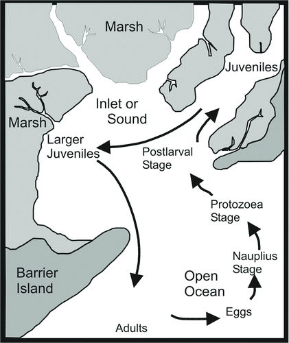
TABLE 1 Parameters and sources of information for Gulf of Mexico blue crab and shrimp models; SAV = submersed aquatic vegetation, SNB = shallow, nonvegetated bottom.
FIGURE 4 Conceptual overview of multiscale modeling for coastal migratory fish species. At the patch scale, data from sampling and experiments (original or reported in the scientific and technical literature) are used to estimate the production of juveniles per unit area (m2). At the landscape scale, geographical information on the extent, distribution, and quality of critical habitats is used to expand unit production to a larger area. At the regional scale (e.g., the U.S. GOM), harvest and economic data are used in models to estimate habitat contributions to major fisheries.
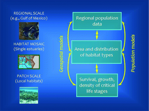
FIGURE 5 Combined monthly landings of brown, pink, and white shrimp (metric tons [mt]) in the U.S. Gulf of Mexico, 1961–2007, as reported by the National Marine Fisheries Service (observed) and estimated by a fishery population model (predicted).
![FIGURE 5 Combined monthly landings of brown, pink, and white shrimp (metric tons [mt]) in the U.S. Gulf of Mexico, 1961–2007, as reported by the National Marine Fisheries Service (observed) and estimated by a fishery population model (predicted).](/cms/asset/d7a9b94b-e77b-42b7-85ea-848a57c64184/umcf_a_703162_o_f0005g.jpg)
TABLE 2 Salmon values per angler-day in Oregon using the travel cost method adapted from Hanna et al. (Citation2006).
TABLE 3 Value in terms of willingness to pay (WTP) to avoid loss in salmon catch for Yaquina Bay aggregated at different spatial scales. Household data are from the 2000 U.S. Census; those for the PNW are aggregates of those for Oregon and Washington. The WTP value for the Yaquina Bay estuary is from Bell et al. (Citation2003).
TABLE 4 Various scales of habitats for Chinook salmon in the Yaquina Bay estuary and the roles they play in the salmon life cycle.
TABLE 5 Estimates of willingness to pay (WTP; dollars per hectare per year except for total [dollars/year]) for each of the major habitat types in the Chinook salmon life cycle. Each estimate assumes that all WTP is assigned to one habitat type rather than being partitioned among habitat types. Subestuary = Yaquina Bay salt marsh habitat.
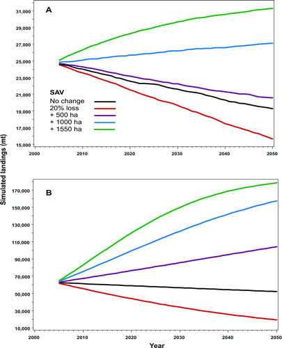
FIGURE 6 Simulated effects of changes in the amount of submersed aquatic vegetation (SAV) habitat on (A) blue crab and (B) penaeid shrimp fisheries in the GOM. Geographic information was combined with data from studies of habitat dependence in early juvenile blue crabs and long-term fishery information to model recruitment (Jordan et al. Citation2009).