
Figures & data
FIGURE 1. Map of the Gulf of Maine, showing the locations of the four study rivers: the Penobscot River (PR), the Kennebec system (KS; includes the Kennebec, Androscoggin, and Sheepscot rivers), the Saco River (SR), and the Merrimack River (MR). Coastal areas (circled) where Atlantic Sturgeon were concentrated include the Bay of Fundy–Minas Basin area (BOF), offshore of PR, offshore of the Kennebec River, the Saco Bay–Scarborough River area, and the Massachusetts coast from Cape Ann to Cape Cod (CA–CC). Also shown are the locations of receiver arrays (circles), UMOOS buoys (triangles), the Saint John River (SJR), Georges Bank (GB), and Browns Bank (BB). Water depth is indicated by shading: 0–100 m (light gray), 100–200 m (medium gray), and over 200 m (dark gray).
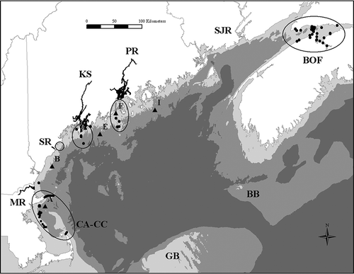
FIGURE 2. Detailed map of the Kennebec system in Maine. Receiver locations are indicated by black circles and river kilometer (rkm). Letters indicate the Sasanoa River (S) and the Back River (B). Dam locations are indicated by bold black lines.
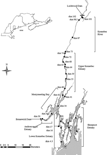
TABLE 1. Details of gill-net sampling conducted in four Gulf of Maine river systems to capture Atlantic Sturgeon, 2006–2013. Nets were constructed of a single mesh size except in the Kennebec system (all mesh is stretch measure).
TABLE 2. Tagging details for Atlantic Sturgeon captured in four Gulf of Maine river systems and tagged with internal or external acoustic transmitters, 2006–2013.
TABLE 3. Locations and deployment periods for receiver arrays where acoustically tagged Atlantic Sturgeon were detected, including those in the four study rivers and independent arrays maintained by cooperating investigators (GOM = Gulf of Maine; tMOLT = Telemetry Monitoring on Lobster Traps; UMOOS = University of Maine Ocean Observing System). Arrays are listed from north to south, with the exception of the UMOOS buoys, which range from Penobscot Bay to Massachusetts Bay. Some receivers from Cape Cod to Cape Ann were deployed year-round or from October to March. Receivers at the entrance of the Saint John River were deployed year-round.
FIGURE 3. Freshwater discharge (m3/s) in the Kennebec River (solid line) and Androscoggin River, Maine (dashed line); bottom water temperature (°C) in the upper Kennebec estuary or the Kennebec River (filled circles) and in the Androscoggin River estuary (open circles); and the putative spawning periods (horizontal lines) in the Kennebec River (KR), upper Kennebec estuary (UKE), and Androscoggin River estuary (AE) based on detections of Atlantic Sturgeon tagged in the Kennebec system (solid line), Penobscot River (short-dashed line), Saco River (long-dashed line), and Merrimack River (dotted–dashed line) during 2009–2014. The star indicates when Atlantic Sturgeon larvae were captured.
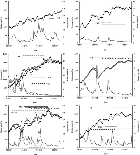
TABLE 4. Number of Atlantic Sturgeon that were tagged in each of the four study rivers and that were detected by riverine and marine receiver arrays within and to the south of the Gulf of Maine, 2006–2014 (tMOLT = Telemetry Monitoring on Lobster Traps; UMOOS = University of Maine Ocean Observing System). Detection locations are listed from north to south; tagging locations are listed from west to east.