Figures & data
FIGURE 1. Map of the Penobscot River estuary with river kilometers delineated. Rkm 0 is at Verona Island and denotes the transition from Penobscot Bay to Penobscot estuary. The former Veazie Dam site (rkm 48) was the upper limit for Atlantic Sturgeon movement in the Penobscot River during the study period. The two southern gates and the southeastern gate were deployed from April to July 2005–2012. Map is from Fernandes et al. (Citation2010). The arrows to the left were added to indicate the river (dots), estuary (long dashes), and bay (solid) segments.
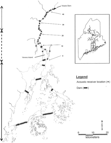
TABLE 1. Summary information for coded acoustic tags used for Atlantic Sturgeon tagging in the Penobscot River and estuary, Maine, 2006–2011.
TABLE 2. Catch per unit effort (CPUE; number captured per hour of soak time) of Atlantic Sturgeon captured in the Penobscot estuary by sampling year and summary statistics.
FIGURE 2. Frequency histograms for (A) total length and (B) mass of Atlantic Sturgeon captured in the Penobscot estuary between 2006 and 2013. The black bars indicate size at first capture and the white bars the lengths of recaptured individuals. Average length and mass are denoted on each histogram by an asterisk.
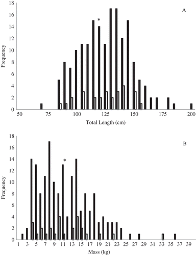
FIGURE 3. Growth in (A) total length (cm) and (B) mass (kg) relative to length of time at large for 11 recaptured Atlantic Sturgeon. Regression analysis showed significant (P < 0.001) positive growth in both variables.
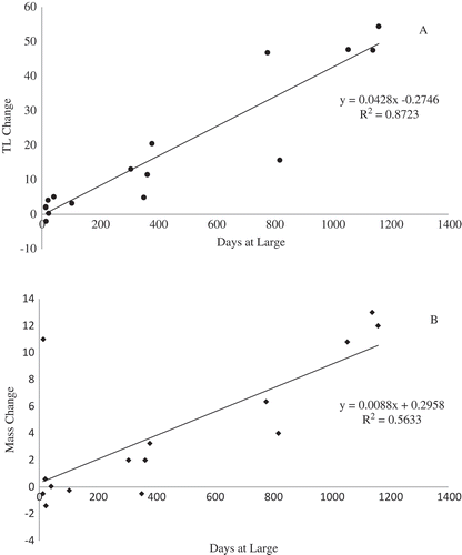
TABLE 3. Proportions of acoustic detections of Atlantic Sturgeon (means ± SDs) by river kilometer (rkm 0 = mouth of river) in the Penobscot River estuary by year and over the entire study. The values for rkm 20 are in bold italics to denote the fact that a significantly higher proportion of individuals used this reach (χ2 = 334.90, P < 0.001).
FIGURE 4. Movement patterns of six acoustically tagged Atlantic Sturgeon in the Penobscot estuary and bay. The same basic pattern was characteristic of 21 of the 30 acoustically tagged sturgeon analyzed: fish moved quickly through the bay and into the estuary in one immigration movement in the spring, remained in the estuary (primarily between rkm 20 and 30) until fall, and then emigrated from the estuary and bay in one quick movement.
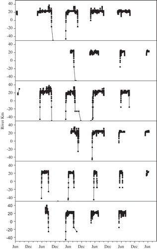
TABLE 4. Numbers of Atlantic Sturgeon acoustically tagged in the Penobscot River that were detected in other areas along the coast of the Northwest Atlantic Ocean. Also shown is the number of detection “events,” which are defined as the number of times that an Atlantic sturgeon was detected by receivers in a particular geographic area. For example, a fish could have been detected by several receivers over the course of several days or weeks or by one receiver on a single day. This information is meant to reflect sturgeons’ passing through an area on several different occasions, usually in different years. The data were obtained opportunistically from collaborators through telemetry data sharing networks such as the ACT Network and OTN.
TABLE 5. Months in which acoustically tagged Atlantic Sturgeon were detected by acoustic receivers in other areas of the Northwest Atlantic Ocean. The numbers in the table represent the number of sturgeon that were present at each location during those months. The table combines data collected over all study years; if an individual remained at a location for several months in a row, each month is included separately.
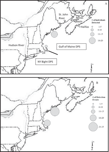
FIGURE 5. (A) Numbers of individual Atlantic Sturgeon acoustically detected in the Penobscot River estuary and (B) numbers of detection events by marine acoustic receivers. The solid line east of Cape Cod, Massachusetts, indicates a rough division between the Gulf of Maine and New York Bight distinct population segments.