
Figures & data
Figure 1. Study domain, showing the location of Jiangxi Province in China (top left), the location of Nanfeng County in Jiangxi (top right), and a close-up view of the region of interest (right).
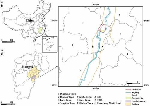
Figure 2. Maps of global integration distribution over time in Nanfeng. (a)end of the Qing Dynasty; (b) 1960; (c) 2004; (d) 2014; (e) 2021. Map lables indicate road names: Jsh: Jianshe Road, Rm: Renmin Road, Xj W: Xujiang West Road, Xj E:Xujiang East Road, Jf: Jiefang Road, Shl: Shengli Road, Chq: Chengqiang Road, Qch: Qincheng Road, Gf: Gaofeng Road, Jt: Jiaotong Road, Zg N: Zigu North Road, Zg: Zigu South Road, Csh: Cangshan Road, Jd: Judu Avenue, Xj: Xinjian Road, Jy S:Juyuan South Road, Jy N:Juyuan North Road, Xf: Xuefu Road, Nx:Nuoxiang Avenue.
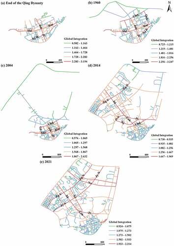
Figure 3. Maps of local integration degree distribution over time in Nanfeng. (a) End of the Qing Dynasty, (b) 1960; (c) 2004; (d) 2014; (e) 2021. Map lables indicate road names: Jsh: Jianshe Road, Rm: Renmin Road, Xj W: Xujiang West Road, Xj E:Xujiang East Road, Jf: Jiefang Road, Shl: Shengli Road, Chq: Chengqiang Road, Jt: Jiaotong Road, Jt S:Jiaotong South Road, Zg N: Zigu North Road, Zg S: Zigu South Road, Csh: Cangshan Road, Jd: Judu Avenue, Xj: Xinjian Road, Jy S:Juyuan South Road, Jy N:Juyuan North Road, Xf: Xuefu Road, Nx:Nuoxiang Avenue.
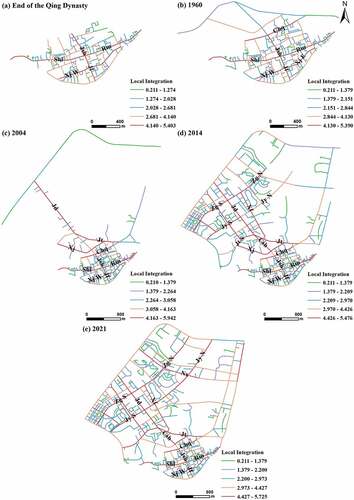
Figure 4. Spatial intelligibility scatterplots of Nanfeng City during: (a) End of the Qing Dynasty; (b) 1960; (c) 2004; (d) 2014; (e) 2021. Trendlines are R2 values are given in each subplot.
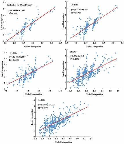
Figure 5. The comparison of spatial textures of the ancient Nanfeng City and the new Nanfeng City.
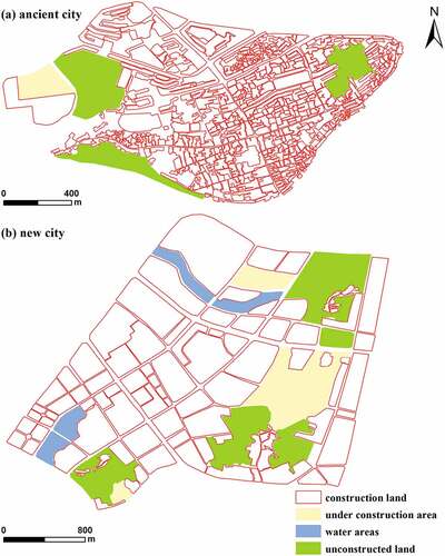
Table 1. Analysis of the Evolutionary Laws and Causes of the Urban Form of Nanfeng City.