Figures & data
Figure 1. The study area are covered with four groups SAR images from Envisat, Radarsat-2 and Sentinel-1 satellite respectively in the period between December 2003 and May 2010, between February 2012 and March 2013, between January 2016 and October 2016 and between October 2016 and October 2017. Envisat, Radarsat-2 and Sentinel-1 satellite are respectively characterized by a swath of 100 × 100 km2, 150 × 150 km2 and 160 × 250 km2. Inset on the left top shows the location of study area highlighted in red relative to Shaanxi Province in China. The inset at the bottom left is the position of 11 levelling stations, which are used to estimate the monitoring accuracy of InSAR results by extracting these InSAR results at same location with levelling.
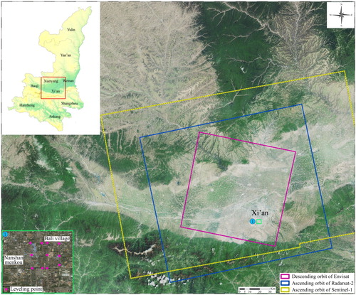
Table 1. Used satellite datasets. Their main parameters, temporal span and Number of used images are listed below.
Figure 2. This map depicts geology and geomorphology characteristics of Xi'an, which is marked with the red square in the lower right image. Xi'an is surrounded by a series of normal fault, among which the ENE oriented loess ridge and those tectonic depression area are interchangeably distributed and ground fissure belts are basically located at the south of loess ridge (Shi Citation2009).

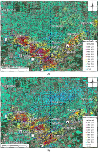
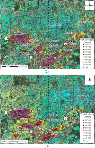
Figure 4. The figure shows the area with subsidence rate beyond 50 mm/year of these five subsidence bowls, changed in 2003–2010, 2012, 2016 and 2017.
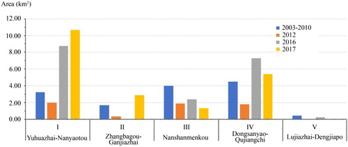
Figure 5. The subsidence contour maps are depicted in based on InSAR results. The land subsidence was further aggravated in 2016 and 2017, especially in the Yuhuazhai-Nanyaotou subsidence bowl and Dongsanyao-Qujiangchi subsidence bowl, whose maximum subsidence rates were all above 60 mm/year. Meanwhile, these land subsidence bowls were mainly correlated with tectonic depression area, which are consisted of loess, interbedded clays, silts and sands. Ground fissure belts are the boundary between loess ridge and tectonic depression area, and also are usually the boundary of subsidence zone. The survey points No. 1, No. 2 and No. 3 plotted in green locate at ground fissure belts f4, f6 and f9. They have different activity and cause to different damage to building or roads.
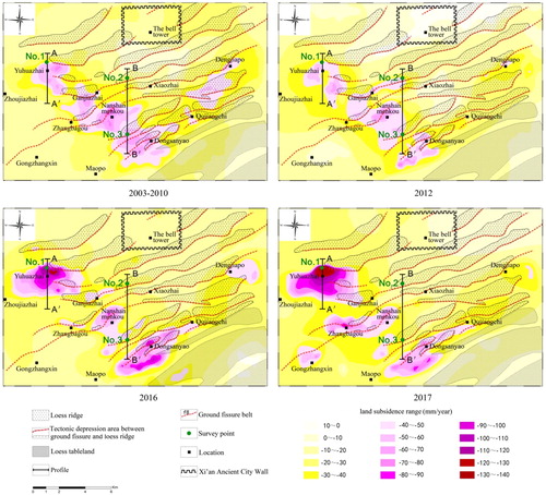
Figure 6. The different kinds of damages caused by ground fissure belt. (a) and (b) are pictures photographed at the survey point No. 1 plotted by green in . The ground fissure belt f4 causes to two building having height difference of about 0.5 m (a) and flowerbeds and ground surface broken (b) at Xi'an International University. (c) The photo at the survey point No. 2 across Chongye Road and (d) the survey point No. 3 located at the northeast of Ducheng village.
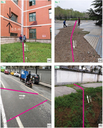
Figure 7. The land subsidence profile of AA′ and BB′ in .
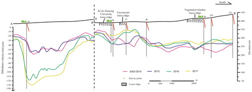
Figure 8. The mechanism map of land subsidence and ground fissure activities in Xi'an. Loess ridge and tectonic depression area are divided by fault, yet the fault does not cut off the ground surface. The fault is characterized by broken soil with low bearing capacity and controls the development of ground fissure. On the basis of the InSAR monitoring, the land subsidence rate in the tectonic depression area is bigger than that in loess ridge, which could further take shape ground fissure belt due to much larger additional stress field arising in tectonic depression area.
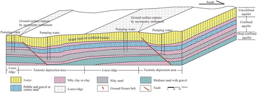
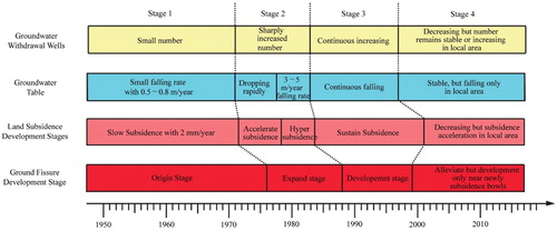
Figure 9. The history of groundwater withdrawal wells and groundwater table, leading to accordingly land subsidence and ground fissure development stages in Xi’an.