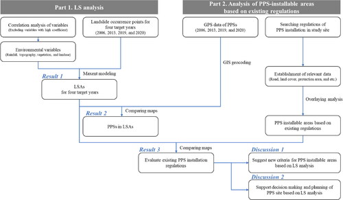
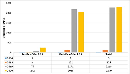
Figures & data
Table 1. Summary of environmental variables exploited in the present study.
Table 2. Regulations for limiting PPS installation in the study area.
Glade T, Crozier M, Smith P. 2000. Applying probability determination to refine landslide-triggering rainfall thresholds using an empirical Antecedent Daily Rainfall Model. Pure Appl Geophys. 157(6–8):1059–1079. Kirschbaum D, Stanley T, Zhou Y. 2015. Spatial and temporal analysis of a global landslide catalog. Geomorphology. 249:4–15. Floris M, Bozzano F. 2008. Evaluation of landslide reactivation: a modified rainfall threshold model based on historical records of rainfall and landslides. Geomorphology. 94(1–2):40–57. Sengupta A, Gupta S, Anbarasu K. 2010. Rainfall thresholds for the initiation of landslide at Lanta Khola in north Sikkim. Nat Hazards. 52(1):31–42. Kim HG, Lee DK, Park C, Kil S, Son Y, Park JH. 2015. Evaluating landslide hazards using RCP 4.5 and 8.5 scenarios. Environ Earth Sci. 73(3):1385–1400. Brand EW, Premchitt J, Phillipson HB. 1984. Relationship between rainfall and landslides in Hong Kong. In Proceedings of 4th International Symposium on Landslides, Vol. 1; [place unknown]. p. 276–284. Dhakal AS, Sidle RC. 2004. Distributed simulations of landslides for different rainfall conditions. Hydrol Process. 18(4):757–776. Gritzner ML, Marcus WA, Aspinall R, Custer SG. 2001. Assessing landslide potential using GIS, soil wetness modeling and topographic attributes, Payette River, Idaho. Geomorphology. 37(1–2):149–165. National Geographic Information Institute. 2000. Digital elevation model. National Geographic Information Institute. 2012. Digital elevation model. National Geographic Information Institute. 2015. Digital elevation model. Aniya M. 1985. Landslide-susceptibility mapping in the Amahata river basin, Japan. Ann Assoc Am Geogr. 75(1):102–114. Pike RJ. 1988. The geometric signature: quantifying landslide-terrain types from digital elevation models. Math Geol. 20(5):491–511. Devoli G, Strauch W, Chávez G, Høeg K. 2007. A landslide database for Nicaragua: a tool for landslide-hazard management. Landslides. 4(2):163–176. Ohlmacher GC, Davis JC. 2003. Using multiple logistic regression and GIS technology to predict landslide hazard in northeast Kansas, USA. Eng Geol. 69(3–4):331–343. Armas I. 2012. Weights of evidence method for landslide susceptibility mapping, Prahova Subcarpathians, Romania. Nat Hazards. 60(3):937–950. Tangestani MH. 2004. Landslide susceptibility mapping using the fuzzy gamma approach in a GIS, Kakan catchment area, southwest Iran. Aust J Earth Sci. 51(3):439–450. Kavzoglu T, Sahin EK, Colkesen I. 2015. Selecting optimal conditioning factors in shallow translational landslide susceptibility mapping using genetic algorithm. Eng Geol. 192:101–112. Viet TT, Lee G, Thu TM, An HU. 2017. Effect of digital elevation model resolution on shallow landslide modeling using TRIGRS. Nat Hazards Rev. 18(2):4016011. Lee S, Min K. 2001. Statistical analysis of landslide susceptibility at Yongin, Korea. Environ Geol. 40(9):1095–1113. Gorsevski PV, Gessler PE, Foltz RB, Elliot WJ. 2006. Spatial prediction of landslide hazard using logistic regression and ROC analysis. Trans GIS. 10(3):395–415. Althuwaynee OF, Pradhan B, Park H-J, Lee JH. 2014. A novel ensemble bivariate statistical evidential belief function with knowledge-based analytical hierarchy process and multivariate statistical logistic regression for landslide susceptibility mapping. Catena. 114:21–36. Lee S, Ryu J-H, Lee M-J, Won J-S. 2006. The application of artificial neural networks to landslide susceptibility mapping at Janghung. Math Geol. 38(2):199–220. Lee S. 2007. Landslide susceptibility mapping using an artificial neural network in the Gangneung area, Korea. Int J Remote Sens. 28(21):4763–4783. Lee S, Lee M-J, Jung H-S. 2017. Data mining approaches for landslide susceptibility mapping in Umyeonsan, Seoul, South Korea. Appl Sci. 7(7):683. Ministry of Environment. 2010. Land cover map. Environ Spat Inf Serv. Ministry of Environment. 2019. Land cover Map. Environ Spat Inf Serv. Tasser E, Mader M, Tappeiner U. 2003. Effects of land use in alpine grasslands on the probability of landslides. Basic Appl Ecol. 4(3):271–280. Pereira S, Zêzere JL, Bateira C. 2012. Assessing predictive capacity and conditional independence of landslide predisposing factors for shallow landslide susceptibility models. Nat Hazards Earth Syst Sci. 12(4):979–988. Ministry of Land Infrastructure and Transport. 2020b. Land area district map. Korea Natl Spat Data Infrastruct Portal.