
Figures & data
Figure 1. The Living Earth LCCS-2 implementation. The hierarchy for the dichotomous phase (L1 – L3) visualised vertically and the modular-hierarchical phase (L4) visualised horizontally. Each level 3 broad land cover type has associated level 4 additional descriptors that are also hierarchical (i.e. between 2–5 tiers). T; tier L; level. Asterisk (*) indicates land cover classes not required for subsequent environmental descriptors in the hierarchy
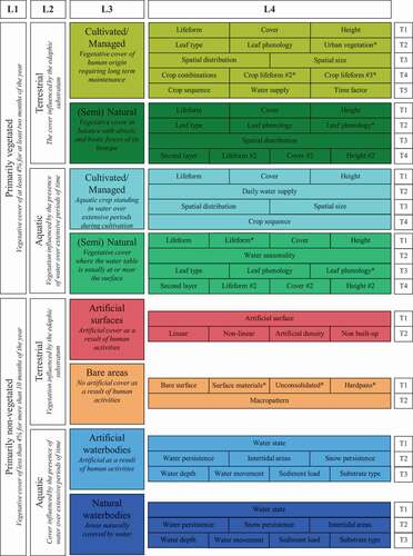
Figure 2. Software design schematic showing ingestion of the data and application of rules to produce level 3 and level 4 classification outputs as both data (8-bit/n-band raster) and coloured RGB images for visualisation
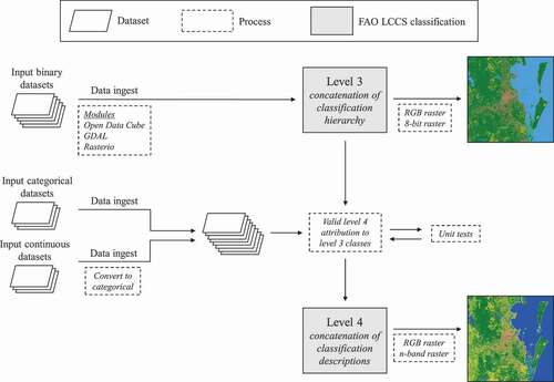
Table 1. Living Earth unique landscape descriptor codes and example descriptions for each level 3 landscape type
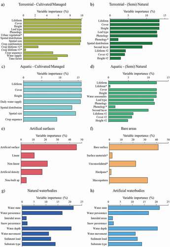
Figure 3. Variable importance of level 4 environmental descriptors for each level 3 broad landscape type. Variable importance is calculated as the number of times categories from the input class were used divided by the total number of unique outputs. Asterisk (*) indicates land cover classes not required for subsequent environmental descriptors in the hierarchy
Supplemental Material
Download Zip (4.6 MB)Data availability statement
The Living Earth system is under Apache 2.0 license, available on bitbucket (https://bitbucket.org/au-eoed/livingearth_lccs). Extensive documentation, such as detailed descriptions of FAO LCCS-2 class modifications for EO, is available in the repository. All 573,307 unique landscape descriptor codes and descriptions are provided in supplementary material along with variable importance scores for each environmental descriptor. Any further requests should be made to the corresponding author.