
Figures & data
Figure 1. The distribution of the 753 lakes in the Northern Hemisphere that were the subject of this study. The dark/light blue circles represent different types of data coverage and the dark/light red triangles represent the use of different verification data.
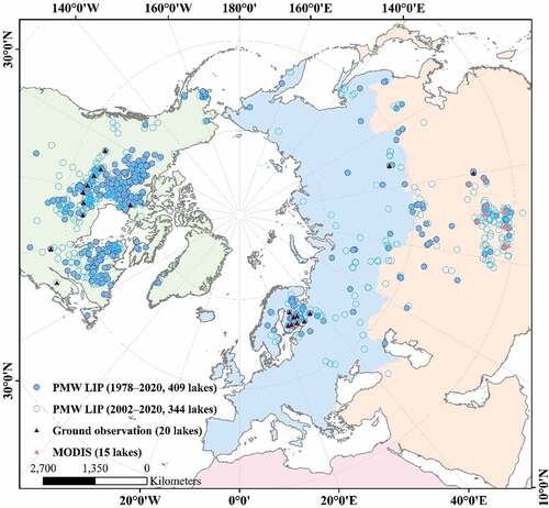
Table 1. Sources and characteristics of PMW data used in this study.
Figure 2. The different components of the lake ice phenology algorithm that was developed in this study.
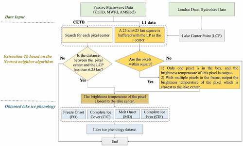
Figure 3. Time-series of brightness temperatures extracted from the PMW data for the period August 2013 to July 2014 at Hala lake. The four MODIS images illustrate the surface ice coverage corresponding to the FO, CIC, MO and CIF dates.
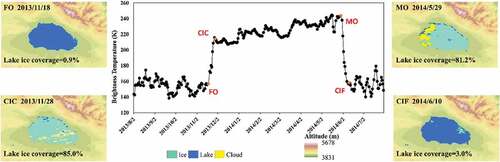
Figure 4. Multi-seasonal brightness temperature time-series for (a) Kayigyalik lake and (b) the lake Hy_ID555, where it proved difficult to identify some of the ice phenology parameters. The surface areas of these lakes are 139.5 km2 and 138.5 km2, respectively, and the lakes are located at (162.5 °W, 61.1 °N) and (92.6 °W, 54.5 °N).
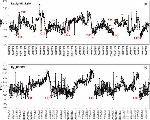
Figure 5. Comparison between (a) the CIC and (b) CIF dates identified from the PMW data and the corresponding values from the NSIDC’s GLRIPD.
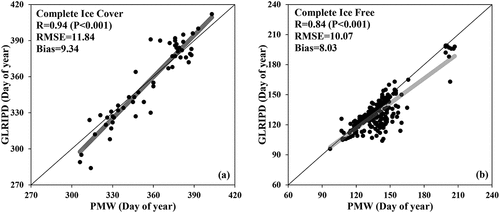
Figure 6. Verification of the lake ice phenology results: results extracted from MODIS data plotted (y-axis) against results extracted from PMW (x-axis) data for (a) the FO, (b) the CIC, (c) the MO and (d) the CIF dates, respectively.
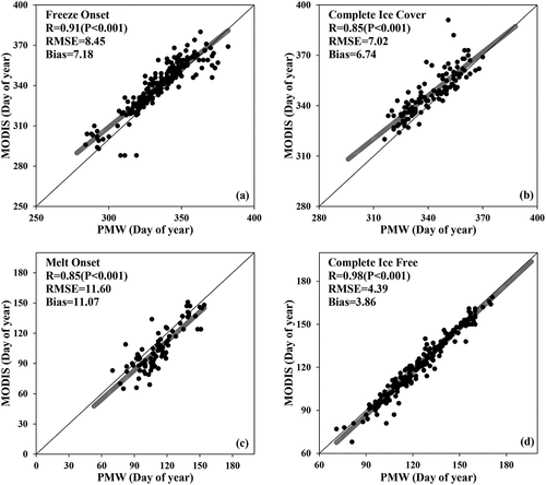
Table 2. Dataset attribute descriptions.
Table 3. Statistics of the lakes in the dataset.
Figure 7. Spatial patterns in the lake ice phenology results: (a), (d), and (e) show the average ice cover duration, the average FO date, and the average CIF date, respectively, during the period 2000 to 2020. (b) and (c) show statistics for the ice-cover duration by region.
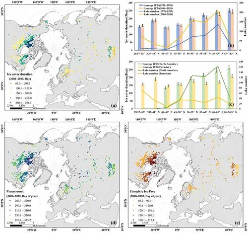
Table 4. Statistics on the number of frozen lakes with areas less than 50 km2.
Supplemental Material
Download MS Word (23.7 KB)Data availability statement
The dataset is openly available from the repository located at http://www.doi.org/10.11922/sciencedb.j00076.00081.