
Figures & data
Table 1. Example of common Earth observation systems and their respective pixel sizes.
Table 2. Comparison of cell sizes between H3 and rHEALPix at various refinement ratios. For this comparison, H3 cells are treated as a circle with an equivalent diameter.
Figure 1. Comparison of the discontinuities and distortions of two equal area representations of the Earth’s surface: a) representation using the rHEALPix hexadron datum; and b) projected representation using EASE Grid version 2. Note that the Orange ellipses are Tissot’s indicatrices, which indicate the amount and direction of surface distortion at various locations.
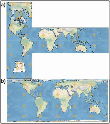
Table 3. Refinement ratio for each level of EASE-DGGS and corresponding cell resolution. Refinement ratio is currently not defined below Level 6.
Table 4. Longitude, latitude, and EASE-Grid coordinates (x, y) for the upper left and lower right of the EASE-DGGS.
Figure 2. Hierarchical schema and decomposition of the Grid ID naming convention.
Figure 3. Representation of the address-indexing scheme underpinning EASE-DGGS. Note that all coordinate pairs are in y, x (row, column) order.
Table 5. The address-indexing scheme is compatible with a 64-bit address space representation.
Table 6. Initial functions supported by GEMS Grid API.
Supplemental Material
Download Latex File (18.1 KB)Supplemental Material
Download PDF (112.5 KB)Data availability statement
There are no data associated with this manuscript.