
Figures & data
Figure 1. The river system including the lower, middle, and upper stretches where the studies reviewed were conducted and the new data analyzed were collected. The spawning areas located within the Lower Snake and Clearwater sub-water sheds covered in are also shown.
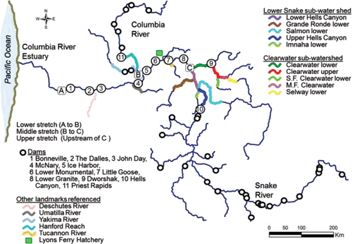
Table 1. Tailrace, ladder, and reservoir distances (km) calculated from the tailrace of Bonneville Dam to the upper end of the south arm of Lower Granite Reservoir.
Figure 2. Net distances fall Chinook salmon adults must travel to complete tailrace-to-dam and reservoir passage events in the lower and middle stretches of the river system, and to the most consistently and heavily used spawning sites within the spawning areas located within the upper stretch.
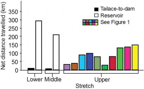
Figure 3. Inter-annual daily mean temperature (°C) measured in the lower stretch of the river system in the tailrace of McNary Dam, the middle stretch in the tailrace of Ice Harbor Dam, and the upper stretch within the spawning areas within the Lower Snake River sub-watershed, and within the Clearwater River lower and upper reaches within the Clearwater River sub-watershed, 2010–2015. Data for the dams are from CBR (Citation2017). Data for the Lower Snake River watershed, S.F. Clearwater lower reach, M.F. Clearwater, and Selway River lower reach were collected by the authors of this review and their staff. Data for the remaining spawning areas within the Clearwater River watershed were collected by the U.S. Geological Survey at Spalding (Station 13342500) and Orofino (Station 13340000), Idaho.
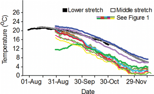
Figure 4. Inter-annual daily mean flow (KCFS) measured in the lower and middle stretches of the river system in the tailraces of McNary and Ice Harbor dams, respectively, 2010–2015 (CBR, Citation2017).
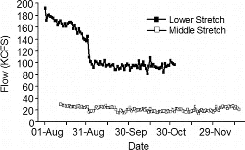
Figure 5. Inter-annual daily mean simulated velocities (cm/s) for the dam tailraces and reservoirs in the lower stretch of the river system (see Eqs. 3 and 4 in ), for the dam tailraces and reservoirs in the middle stretch of the river system (see Eqs. 9 and 10A–10O in ), and for the Upper and Lower Hells Canyon spawning areas (distance weighted 1-D modeling; Borden and Manning, Citation2011).
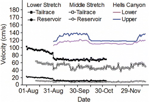
Table 2. Snake River basin fall Chinook salmon spawning areas located upstream of Lower Granite Dam. Accessible channel length is given in kms. Channel length (kms) was determined from river charts or redd locations documented by the authors except for the Lower Snake upper and lower reaches that are from Dauble et al. (Citation2003). Abbreviations: rkm, river km (river mouth = rkm 0); D., Dam; Res., Reservoir; S. F., South Fork; M.F., Middle Fork.
Figure 6. Inter-annual mean total redd counts estimated on the end dates of six spawning intervals (21-Sep‒04-Oct, 05-Oct‒18-Oct, 19-Oct‒01-Nov, 02-Nov‒15-Nov, 16-Nov‒29-Nov, 30-Nov‒13-Dec) from data collected during aerial surveys conducted by the authors and their staff during 1991‒2015 (methods, Groves and Chandler, Citation1999; Groves et al., Citation2013, Citation2016) within the primary, secondary, and tertiary spawning areas used by Snake River basin fall Chinook salmon upstream of Lower Granite Reservoir (; ).
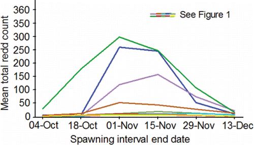
Figure 7. Standardized passage date distributions (2010‒2015) at Bonneville (panel A), McNary (panel B), Ice Harbor (panel C), and Lower Granite (panel D) dams for PIT-tagged, hatchery-origin fall Chinook salmon adults compared to the run schedules at those dams (CBR, Citation2017).
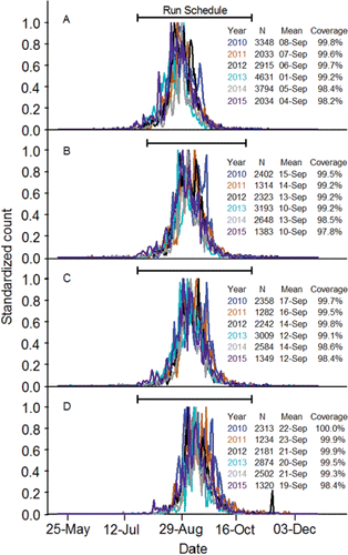
Table 3. Information on fallback of presumed, upriver bright fall Chinook salmon adults at the lower dams within the lower and middle stretches of the river system. The data are from Boggs et al. (Citation2004; years 1998, 2000, and 2001) and was pooled across years for this table. The denominator for gross and net fallback percentages was the number of unique fish that passed. The numerator for net fallback was the number of unique fish that re-ascended the ladder (n under Reascension). The denominator for all other percentages was the number of unique fallbacks.
Figure 8. Relation between the percent of presumed upriver bright fall Chinook salmon adults that used cool water tributaries for more than 12 h along the lower stretch of the river system and mean weekly water temperatures at Bonneville Dam. Circles represent 52 weekly bins (mean 41 fish/bin; range 4‒122 fish/bin). The curve is the exponential regression line that best fits the data (r2 = 0.80; P ≤ 0.0001; percent = 6.558‒7e0.802xtemperature). The figure originally published in Goniea et al. (Citation2006) was provided for use by the editorial staff of Transactions of American Fisheries Society. The font was modified and color added.
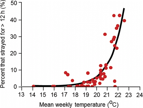
Figure 9. Travel time distributions (2010‒2015) for PIT-tagged, hatchery-origin fall Chinook salmon adults that swam from Bonneville Dam to Lower Granite Dam. The lower whisker is the 2.5th percentile, the bottom of the box is the 25th percentile, the horizontal line in the box is the median, the circle in the box is the mean, the upper end of the box is the 75th percentile and the top whisker is the 97.5th percentile. The numbers above the 97th percentile are the sample sizes.
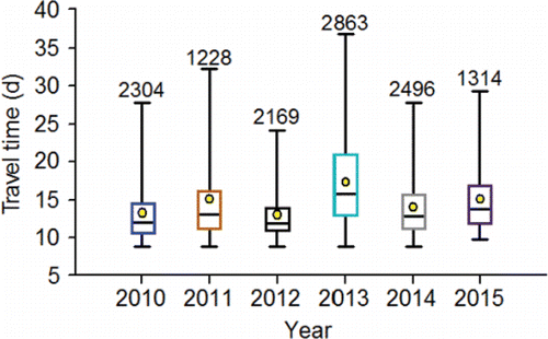
Figure 10. Upstream movement rate (km/d) distributions (2010‒2015) calculated for PIT-tagged, hatchery-origin fall Chinook salmon adults that swam from Bonneville Dam to McNary Dam (BONMCN), McNary Dam to Ice Harbor Dam (MCNICH), and Ice Harbor Dam to Lower Granite Dam (ICHLGR). The lower whisker is the 2.5th percentile, the bottom of the box is the 25th percentile, the horizontal line in the box is the median, the circle in the box is the mean, the upper end of the box is the 75th percentile and the top whisker is the 97.5th percentile. The numbers above the 97th percentile are the sample sizes.
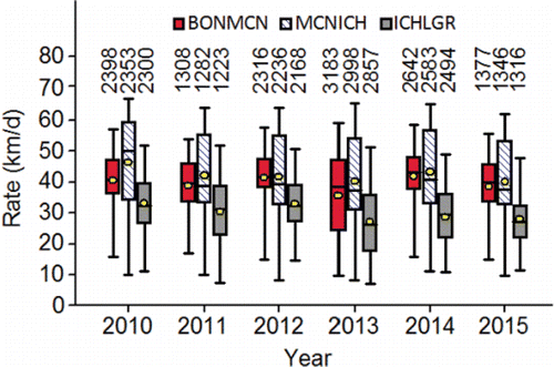
Figure 11. Upstream movement rates (km/d) of PIT-tagged, hatchery-origin fall Chinook salmon adults that swam from Bonneville Dam to McNary Dam plotted against the mean temperature measured in the tailrace of McNary Dam for each fish between detection at the two dams during 2010‒2015. Annual sample sizes are given in .
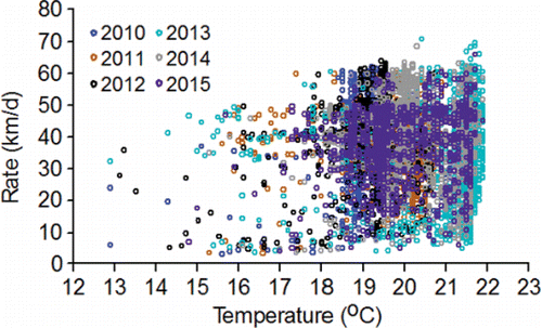
Figure 12. The relation between the annual mean upstream movement rate (km/d) and annual mean temperature calculated from the data in .
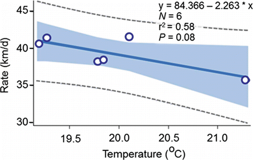
Table 4. Mean travel times of PIT-tagged, hatchery-origin fall Chinook salmon adults from Bonneville Dam to McNary Dam for fish that were and were not detected at Lower Granite Dam (i.e., successful [S] and unsuccessful [U] migrants). Fisher's test for honestly significant differences showed that every annual mean travel time (loge transformed) of successful migrants was significantly (P < 0.05) shorter than the corresponding annual mean travel time of unsuccessful migrants. Results of logistic regression models fitted separately by year and jointly across years (All) to predict g(x) and calculate the probability of success Pi (set at 0.5; Pi = eg(x) / 1 + eg(x)) of individual fish from their travel times are given. The percentage of the known unsuccessful and successful migrants that were predicted to be successful by those models is also given.
Figure 13. The relation between the annual percentages of the PIT-tagged, hatchery-origin fall Chinook salmon adults that migrated successfully between McNary and Lower Granite dams, and the annual mean temperature measured in the tailrace of Ice Harbor Dam from 12-Aug to 14-Sep, 2010‒2015.
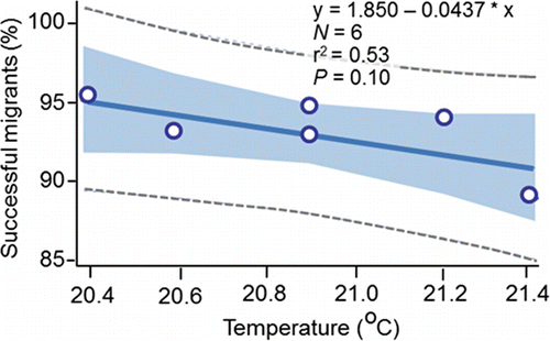
Figure 14. Travel time distributions (across 2010‒2015) calculated for PIT-tagged, hatchery-origin fall Chinook salmon adults that swam upstream from Bonneville Dam to McNary Dam, and were subsequently detected or not detected at Lower Granite Dam (i.e., successful panel A and unsuccessful migrants panel B).
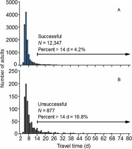
Figure 15. Pie charts showing the annual percentages (2010‒2015; charts A‒F, respectively) of the PIT-tagged, hatchery-origin fall Chinook salmon adults that did not migrate successfully from McNary to Lower Granite Dam (N = 877), but were last detected as permanent fallbacks downstream of McNary Dam, as mid-Columbia strays between McNary and Priest Rapids dams, as undershoots between Ice Harbor and Little Goose dams, or as upper Columbia strays at dams, within tributaries, or at hatcheries upstream of the Lower Snake River mouth.
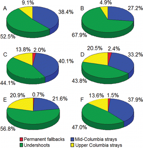
Figure 16. The relation between the annual (2010‒2015) percentages of the PIT-tagged, hatchery-origin fall Chinook salmon adults that were identified as upper Columbia strays () and annual mean temperature measured in the tailrace of Ice Harbor Dam from 12-Aug to 14-Sep, 2010‒2015.
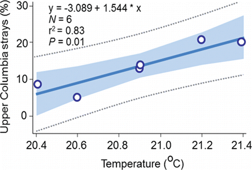
Figure 17. Examples of detection plots for natural-origin male (panel A), natural-origin female (panel B), and hatchery-origin female (panel C) fall Chinook salmon adults including the migratory phase, transition date and location, search phase, spawning site selection, and detections made after spawning site selection. The arrows next to y axis show the river km where the adults were released as Age-0 juveniles. The figure originally published in Connor and Garcia (Citation2006) was provided for use by the editorial staff of Transactions of American Fisheries Society. The font was modified and color added.
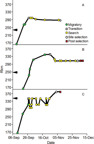
Figure 18. The relation between travel time (d) from Lower Granite Dam to spawning site selection and day of the initiation of redd construction along the Upper and Lower Hells Canyon spawning areas combined and passage day of year (01/01 = 1) at the dam for radio-tagged fall Chinook salmon adults, 1998, 2000, and 2001. The data for the regression were collected by Connor and Garcia (Citation2006).
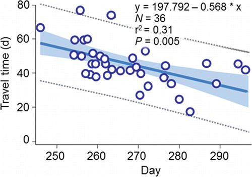
Figure 19. An overhead example of a spawning site located along the Upper Hells Canyon spawning area including spawning substrate distribution (e.g., ), channel bathymetry, redd locations, and a sampling transect where depth, velocity, and substrate were measured to quantify spawning habitat. The figure originally published in Connor et al. (Citation2001) was provided for use by the editorial staff of Northwest Science. The font was modified and color added.
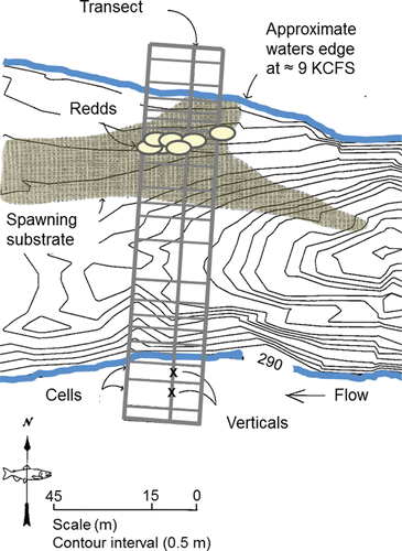
Figure 20. Frequency distribution of combined dominant (left) and subdominant (right) substrate types observed at fall Chinook salmon redds in the Upper and Lower Hells Canyon spawning areas, 1993‒1995. The figure originally published in Groves and Chandler (Citation1999) was provided for use by the editorial staff of Transactions of the American Fisheries Society. The font was modified and color added.
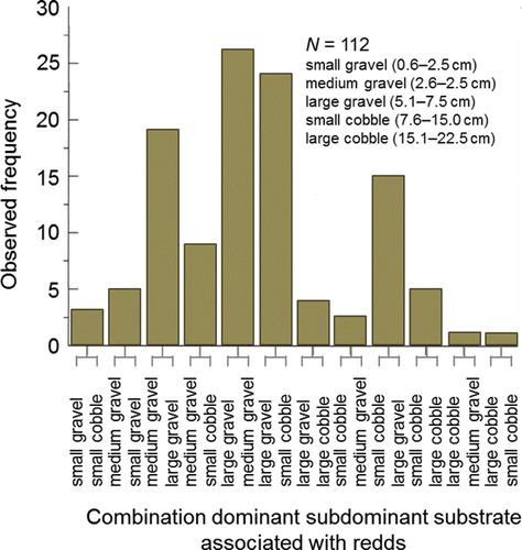
Figure 21. Frequency distribution of water depths measured at fall Chinook salmon redds in the Upper and Lower Hells Canyon spawning areas, 1993‒1995. Reproduced from Groves and Chandler (Citation1999) with permission from the American Fisheries Society. The font was changed and color added.
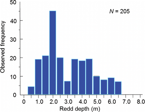
Figure 22. Frequency distribution of mean water column (panel A) and substrate-level (panel B) velocities measured at fall Chinook salmon redds in the Upper and Lower Hells Canyon spawning areas, 1993‒1995. Reproduced from Groves and Chandler (Citation1999) with permission from the American Fisheries Society. The font was changed and color added.
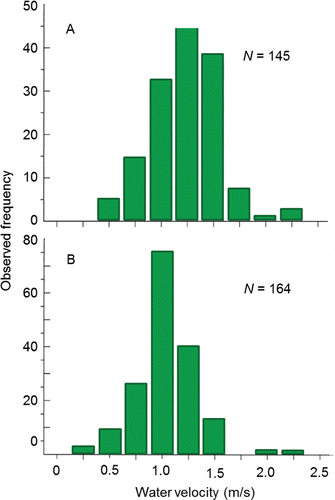
Figure 23. The post-spawn incubation environment according to the conceptual model of Geist and Dauble (Citation1998) including downwelling (A) and upwelling (B) of surface water (i.e., river water), and ground water inflow (C). Not drawn to scale. The figure of the fish digging the redd was adapted from Burner (Citation1951) with permission of the National Oceanic and Atmospheric Administration. The font was changed and color added.
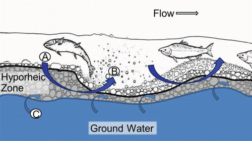
Table 5. Embryo loss (%) from fertilization to button up (equivalent to fry emergence in the wild) and degree days above 20°C (DD>20) measured on female fall Chinook salmon fitted with temperature loggers at Ice Harbor Dam, trapped at Lower Granite Dam, and spawned at either Lyons Ferry or Nez Perce Tribal hatcheries during 2004 (from Mann, Citation2007). To calculate DD>20 in the middle stretch of the river system (i.e., observed), the daily mean temperature each fish was exposed to between Ice Harbor and Lower Granite dams was determined. If a daily mean temperature was greater than 20°C, 20 was subtracted from that mean to obtain a daily difference. The daily differences were summed to calculate DD>20 in the middle stretch. Bonneville Dam passage dates and DD>20 in the lower stretch of the river system were simulated (Eq. 14; ) to provide data for fitting Eq. 15 () that predicted embryo mortality from a spatially-extended value of DD>20.
Figure 24. The relation between degree days above 20°C (DD>20) calculated for the female parent and embryo loss measured from spawning to the button-up stage (equivalent to fry emergence in the wild). The equation was fitted by Mann (Citation2007). The untransformed data are given in (x = DD>20 in the middle stretch of the river system; y = observed embryo loss).
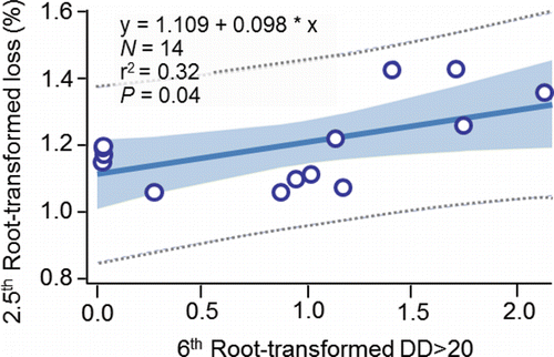
Figure 25. Embryo loss (%) predicted (± 95% CI) for the primary, secondary, and tertiary fall Chinook salmon spawning areas in the sub-watersheds that make up the upper stretch of the river system. The equation was: embryo loss (%) = -52.689 – 0.160*S0.85 + 0.186*S0.85S0.85 (N = 8; r2 = 0.89; P = 0.004); S0.85 was the mean percentage of fines less than 0.85 mm in diameter in each of the substrate samples collected by either Arnsberg et al. (Citation1992) or Bennett et al. (Citation2003). The prediction marked by an asterisk in panel was 105.1 ± 27.8%.
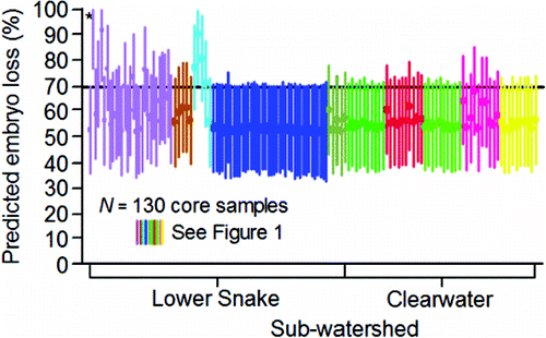
Figure 26. Stages of the model developed to simulate somatic energy use, migration success, and spawning success of PIT-tagged, hatchery-origin fall Chinook salmon adults during 2010‒2015.
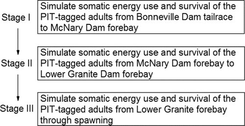
Figure 27. The percentage of the apparent ocean age II, III, IV, and V PIT-tagged, hatchery-origin fall Chinook salmon adults that migrated successfully during Stage II modeling (i.e., McNary Dam forebay to Lower Granite Dam forebay) that were classified as successful spawners, 2010–2015. The numbers above the bars are the sample sizes of fish classified as successful spawners.
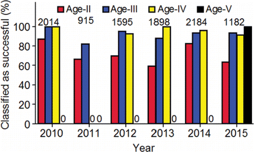
Figure 28. Pre-spawning mortality (%) distributions (5th, 25th, 50th, 75th, and 95th percentiles) for basin-level groupings of fall Chinook salmon calculated with empirical data from Bowerman et al. (Citation2016) compared to the distributions calculated from simulations made with the somatic energy use model for the PIT-tagged, hatchery-origin fall Chinook salmon adults in the Upper Hells Canyon spawning area (UHC). The numbers above the 95th percentile are the sample sizes. Other abbreviations: CLR, Clearwater River lower reach, ID; KAL, Klamath Falls, OR; MCOL, Mid-Columbia, OR; PUG, Puget Sound, WA; SAC, Sacramento, CA; SJO, San Joaquin, CA. The data were provided by the corresponding author of Bowerman et al. (Citation2016), except for the Clearwater River lower reach that were taken from Arnsberg et al. (Citation2007, Citation2010) and Arnsberg and Kellar (Citation2007a, Citation2007b, Citation2007c).
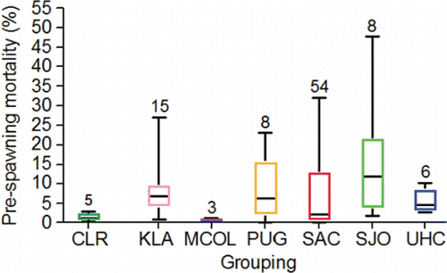
Figure 29. The percentages of the PIT-tagged, hatchery-origin fall Chinook salmon adults that were classified as unsuccessful spawners and fell into the pre-spawning or premature spawning mortality categories, 2010–2015. The numbers above the bar are the sample sizes of fish classified as unsuccessful spawners.
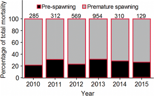
Figure 30. Simulated daily pre-spawning mortality rates (%) of PIT-tagged, hatchery-origin fall Chinook salmon adults along the Upper Hells Canyon spawning area, 2010–2015.
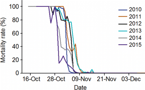
Figure 31. Standardized, simulated spawning initiation date distributions for PIT-tagged, hatchery-origin fall Chinook salmon adults classified as premature spawning mortalities and successful spawners (combined) compared to the actual distributions observed during the four annual redd survey intervals along the Upper Hells Canyon spawning area, 2010–2015 (data collected by the authors and their staff; e.g., Groves et al., Citation2013).
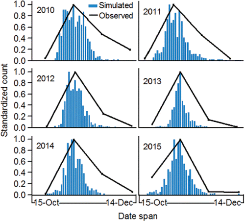
Figure 32. Standardized, simulated spawning initiation date distributions for PIT-tagged, hatchery-origin fall Chinook salmon adults that fell into the pre-spawning mortality category (had they survived to initiate spawning), into the category of premature spawning mortalities, or were classified as successful spawners, 2010–2015.
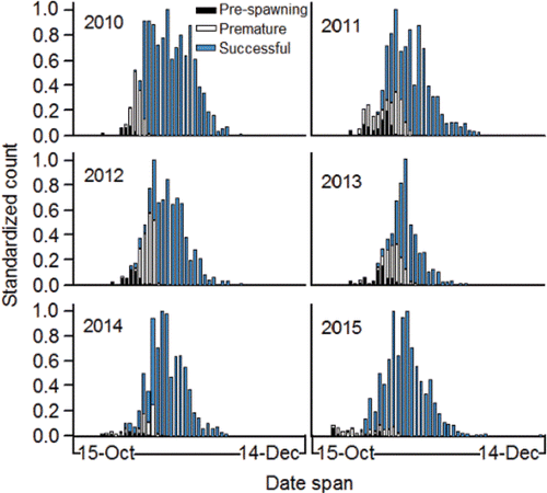
Figure 33. Annual mean (95% C.I.) cumulative temperature exposures (panel A) and expended useable energy (cumulative %; panel B) simulated during Stage I modeling (i.e., Bonneville Dam tailrace to McNary Dam forebay) for PIT-tagged, hatchery-origin fall Chinook salmon adults that were either successful or unsuccessful migrants from McNary Dam forebay to Lower Granite Dam forebay, 2010–2015. Sample sizes are given in Table 4.
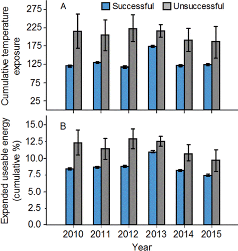
Figure 34. Annual mean (95% C.I) day of passage at Lower Granite Dam (panel a; numbers in bars = n), simulated cumulative temperature exposures between Bonneville and Lower Granite dams (panel b), and simulated expended useable energy (cumulative %; panel c) during Stages I and II for PIT-tagged, hatchery-origin fall Chinook salmon adults that were classified as either successful or unsuccessful spawners, 2010–2015.
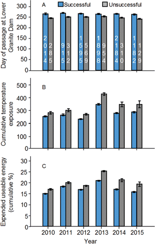
Figure 35. Annual cumulative temperature exposure indices for the PIT-tagged, hatchery-origin fall Chinook salmon adults that successfully migrated to Lower Granite Dam forebay, and were subsequently classified as either successful (S) or unsuccessful (U) spawners during 2010–2015. Sample sizes are given in .
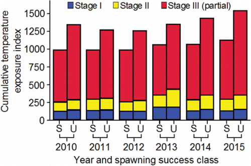
Table 6. Logistic regression diagnostics for models fitted to predict the probability of a PIT-tagged, hatchery-origin fall Chinook salmon adult being a successful spawner based on fish weight at Bonneville Dam, and cumulative temperature exposure during Stages I, II, and II. Abbreviations: CUMDEGR, cumulative temperature exposure; S, successful spawner; U, unsuccessful spawner.
Figure 36. The mean (95% C.I.) total amount of simulated somatic energy used for swimming during tailrace-to-dam passage, reservoir passage, and pre-spawning movement events by PIT-tagged, hatchery-origin fall Chinook salmon adults classified as successful spawners expressed in kcal (panel A) and kcal/km/d (panel B), 2010–2015. Sample sizes are given in .
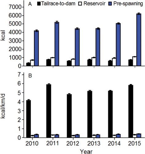
Figure 37. Median tailrace-to-dam passage time (d) of presumed upriver bright fall Chinook salmon adults at dams in the lower and middle stretches of the river system during 1998, 2000, and 2001. The inter-annual mean (±95%CI) are given above the bars. The data are from Keefer et al. (Citation2004). Abbreviations: Bonneville, BON; The Dalles, DAL; John Day, JD; McNary, MCN; Ice Harbor, ICH;, Lower Monumental, LMN; Little Goose, LGS; and Lower Granite, LGR.
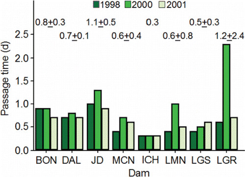
Figure 38. System-wide values of degree days above 20°C (DD>20) for PIT-tagged, hatchery-origin fall Chinook salmon adults that were classified as successful spawners by the somatic energy use model plotted against the observed dates of passage at Bonneville Dam of those adults, 2010‒2015.
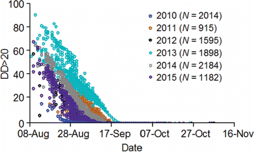
Figure 39. The annual mean (±95% C.L.) number of degree day units above 20°C (DD>20) accumulated by PIT-tagged, hatchery-origin fall Chinook salmon adults that were classified as successful spawners by the somatic energy use model as they swam through the lower, middle, and upper stretches of the river system, 2010‒2015. The upper stretch was divided into Lower Granite Reservoir, Lower Hells Canyon, and Upper Hells Canyon.
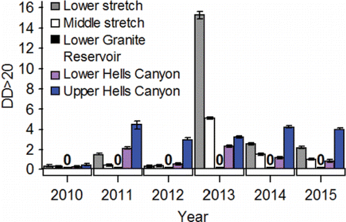
Figure 40. Simulated embryo loss (%) due to exposure to degree days above 20°C for PIT-tagged, hatchery-origin fall Chinook salmon adults that were classified as successful spawners by the somatic energy use model plotted against the simulated spawning initiation dates of those adults along the Upper Hells Canyon spawning area, 2010‒2015.
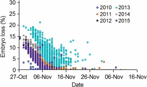
Figure 41. Baseline (1991‒2006 average) and adjusted 2080 flows for Upper Hells Canyon from Hells Canyon Dam to the Imnaha River mouth. Refer to the Appendix to see how flows were simulated starting with information provided by Hamlet et al. (Citation2010). The figure style is also attributed to Hamlet et al. (Citation2010).
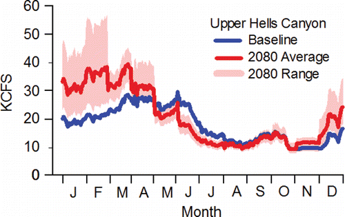
Figure 42. The baseline scenarios (1991‒2006 average), and 2080 average flow scenarios adjusted to match the pattern in the hydrograph in the baseline scenario, for Upper Hells Canyon from Hells Canyon Dam to the Imnaha River mouth (panel A), Upper Hells Canyon from the Imnaha River mouth to the Salmon River mouth (panel B), Lower Hells Canyon from the Salmon River mouth to Grande Ronde River mouth (panel C), Lower Hells Canyon from the Grande Ronde River mouth to the Clearwater River mouth (panel D), Lower Granite Dam (panel E), Ice Harbor Dam (panel F), and McNary Dam (panel G). Refer to the Appendix to see how flows were simulated starting with information provided by Hamlet et al. (Citation2010).
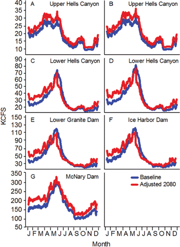
Figure 43. Baseline (1991‒2006 average) and adjusted 2080 daily mean temperatures for Upper Hells Canyon (panel A), Lower Hells Canyon (panel B), Lower Granite Dam (panel C), Ice Harbor Dam (panel D), and McNary Dam (panel E). Refer to the Appendix to see how temperatures were simulated starting with information provided by Hamlet et al. (Citation2010).
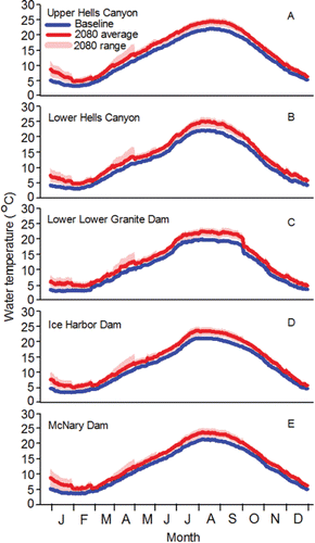
Figure 44. Simulated success rates (%) migration from Bonneville Dam to the Upper Hells Canyon spawning area, from Bonneville Dam to spawning completion, and from Bonneville Dam to fry emergence simulated for natural-origin fall Chinook salmon females under the baseline and 2080 scenarios, where N is the starting number of adults that arrived at Bonneville Dam and n is the number of adults that successfully completed each event given above the bars (except in the case of emergence; see text for description).
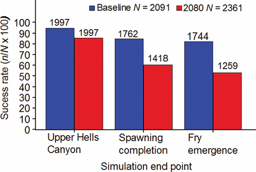
Table A1. The regression equations used in the somatic energy model and other models developed in this review. Abbreviation: LGR, Lower Granite.
Figure 45. Effective spawn timing distributions simulated for natural-origin fall Chinook salmon females along the Upper Hells Canyon spawning area under the baseline and 2080 scenarios, where N is the total number of fish classified as successful spawners expressed in adult equivalents (see text), and n is the total number of adult equivalents in each spawning interval given above the bars.
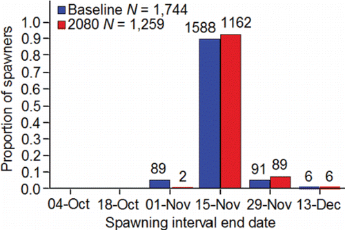
Table A2. A movement template for a hatchery-origin female adult that had been PIT-tagged and released upstream of Lower Granite Dam as a subyearling in 1999, radio tagged at Lower Granite Dam (rkm 173) as a 68-cm FL (measured), 3.3 kg (predicted1) adult female in 2001, tracked to the lower end of the spawning grounds 0.4 d after being released at the dam, and then tracked to a spawning site (rkm 379.2) along the Upper Hells Canyon spawning area where it was assumed to have initiated redd construction. Distance and time weighted velocities and temperatures for 2010 were entered into the template. Abbreviation: DOY.h/24, day of year.hour divided by 24.
Table A3. The historical combined monthly average total runoff and base flows for the Snake River basin upstream of Hells Canyon Dam expressed as an average depth (inches); the average, minimum, maximum value of that combined monthly average from the GCM for the B1 greenhouse gas scenario; and the adjustment statistics (historical divided by the average, minimum, or maximum values) for each month used to adjust the 2080 daily simulation flows for expected hydropower operations for Upper Hells Canyon from Hells Canyon Dam to the Imnaha River mouth. Details are given in Hamlet et al. (Citation2010). The data were downloaded from http://warm.atmos.washington.edu/2860/products/sites/?site = 4010 (Available May 2017).
Table A4. The series of equations that were used to calculate simulation flows under the 2080 climate change scenario. Abbrevations: Q^, location-specific equation; 2080 Qsimadj, daily flow data adjusted for 2080 conditions assuming the dam could be operated to match the baseline hydrograph pattern; 2080 Qsim, daily flow data adjusted for 2080 conditions in an unregulated tributary. The locations are shown in .
Table A5. Information on regression equations fitted to predict baseline monthly average water temperatures at the locations required for simulating migration and spawning success of Snake River fall Chinook salmon within the Upper Hells Canyon spawning area from historical monthly average air temperatures predicted from meteorological data and the GCM models by Hamlet et al. (Citation2010). The historical air temperatures were downloaded from http://warm.atmos.washington.edu/2860/products/sites/?site = 4010 (Available May 2017).
Table A6. The historical monthly average air temperatures (°C) predicted from meteorological data and the GCM models by Hamlet et al. (Citation2010) for the Snake River basin upstream of Hells Canyon Dam, baseline monthly average water temperatures (°C) measured in Upper Hells Canyon during 1991‒2006, and the baseline monthly average water temperatures in Upper Hells Canyon predicted with the January‒July and August‒December regression equations in . The average, minimum, maximum values of the 2080 monthly average air temperatures were taken from the GCMs using the B1 greenhouse gas scenario and used to predict 2080 monthly average water temperatures with those regression equations. Adjustment statistics (predicted baseline monthly average water temperatures divided by the predicted 2080 monthly average water temperatures) are also given. Details are reported in Hamlet et al. (Citation2010). The data were downloaded from http://warm.atmos.washington.edu/2860/products/sites/?site = 4010 (Available May 2017).