Figures & data
Figure 1. Study area, the Napo Basin in Ecuador. (A) Altitudinal gradient, main rivers, floodplains systems, and some main rivers and cities in the basin. (B) Location of all vertebrate species records obtained from museum databases and online data-sets, and (C) sampling localities surveyed for freshwater invertebrates and amphibians during this study.
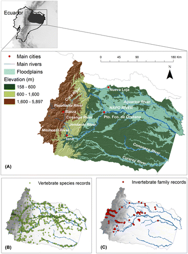
Table 1. Environmental data layers used in the species and family distribution models.
Figure 2. Species richness for freshwater vertebrates in the Napo Basin. Species richness maps were obtained from the summation of the species distribution models of (A) all species, (B) amphibians, (C) birds, (D) mammals, (E) reptiles, and (F) fish. Main state protected areas in the Napo Basin are: Yasuní National Park (Y NP), Cuyabeno Faunistic Reserve (C FR), Cayambe Coca National Park (CC NP), Sumaco Napo-Galeras National Park (SN NP), Antisana Ecological Reserve (A ER), Colonso-Chalupas Biological Reserve (CC BR), and Llanganates National Park (L NP).
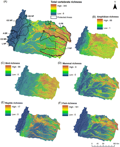
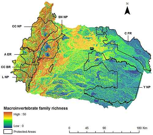
Figure 3. Family richness for freshwater invertebrates in the Napo Basin. This map was obtained from the summation of 54 invertebrate family distribution models. Main state protected areas in the Napo Basin are: Yasuní National Park (Y NP), Cuyabeno Faunistic Reserve (C FR), Cayambe Coca National Park (CC NP), Sumaco Napo-Galeras National Park (SN NP), Antisana Ecological Reserve (A ER), Colonso-Chalupas Biological Reserve (CC BR), and Llanganates National Park (L NP).