Figures & data
Figure 1. Representatives of Kielmeyera (Calophyllaceae) from the Atlantic Forest. (A) K. albopunctata: branch with flowers; (B, C) K. argentea: (B) shrub in restinga―quaternary sandy coastal plain―vegetation, Salvador, Bahia state, (C) opened fruit, showing seeds; (D, E) K. elata: (D) tree in a wet forest, Ilhéus, southern Bahia, (E) branch with leaves; (F, G) K. ferruginosa: (F) trunk with bark partially removed to show the orange latex, (G) a population in a flooded arboreal restinga, Una, southern Bahia; (H) K. membranacea: branch with a flower; (I) K. marauensis: branch with flowers; (J, K) K. neglecta: (J) tree in a wet forest, Serra Grande, southern Bahia; (K) branch with flowers; (L, M) K. reticulata (L) branch with flowers, (M) fruit; (N, O) K. rugosa: trunk with bark partially removed to show the yellowish latex, (N) branch with a flower, in shrubby tabuleiro, a semideciduous coastal forest, northern Bahia. Photos by F.S.E. Santo (A, H, J); A.P.B. Santos (B–G, L, N, O); I.S. Abreu (M); D.N. Carvalho (I, K).
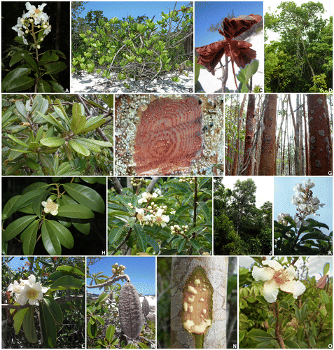
Table 1. Number of records from the river basins of the Atlantic Forest (southwards) per species of Kielmeyera.
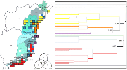
Figure 2. Aspects of Kielmeyera distribution in Atlantic Forest on a grid of 0.5° × 0.5° cells, showing the river basins along the coast. (A) sampling; (B) richness; (C) H’ diversity; (D) corrected weighted endemism.
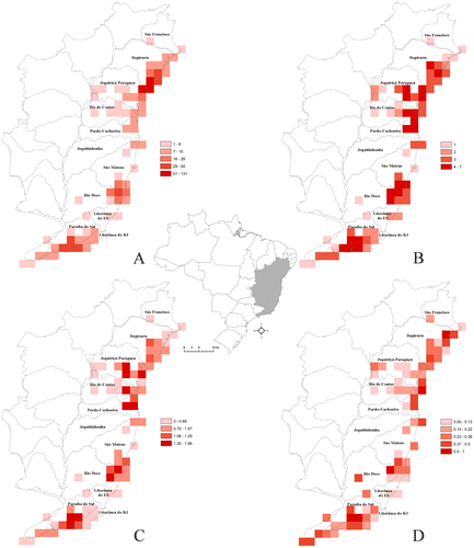
Figure 3. Cluster analysis (Sorensen dissimilarity coefficient) of the composition of Kielmeyera in Atlantic Forest, on a grid of 0.5° × 0.5° cells. Colours in the dendogram correspond to those on the map (black lines correspond to white cells) and node labels correspond to the distance (dissimilarity) between clusters. The Venn diagram shows the number of species in the states of Bahia (BA), Espírito Santo (ES) and Rio de Janeiro (RJ). On the map, black lines indicate states and grey lines indicate river basins (in different colours only to favour visualization).