Figures & data
Figure 1. Geographic distribution range of Parastacus pugnax in Chile. a) The gray outline indicates the historical distribution range and the black outline indicates the study area in the Choapa River Basin, northern-central Chile. Climatic and hydrographic regions of Chile (Geographic Military Institute of Chile – IGM) [Citation14,Citation15]. b) Altitudinal stratification of the sampling sites. Ar = Arid, SAr = Semiarid, Me = Mediterranean, TW = Temperate Wet, CW = Cold Wet. * = DGA fluviometric station.
![Figure 1. Geographic distribution range of Parastacus pugnax in Chile. a) The gray outline indicates the historical distribution range and the black outline indicates the study area in the Choapa River Basin, northern-central Chile. Climatic and hydrographic regions of Chile (Geographic Military Institute of Chile – IGM) [Citation14,Citation15]. b) Altitudinal stratification of the sampling sites. Ar = Arid, SAr = Semiarid, Me = Mediterranean, TW = Temperate Wet, CW = Cold Wet. * = DGA fluviometric station.](/cms/asset/ecc44fac-b8ca-42aa-a781-6b9168558e6d/tneo_a_2049173_f0001_b.gif)
Figure 2. External morphology of a Parastacus pugnax specimen from the Choapa River Basin. a) Dorsal view of the carapace (Ro: rostrum, PC: postorbital carinas, CG: cervical groove). b) Dorsal view (Che: P1 chelae). c) Ventral view (Che: P1 Chelae). d) Lateral view (PL: pleon). Scale bar: 20 mm.
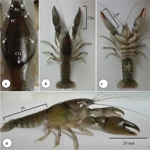
Figure 3. Altitudinal distribution range in the Choapa River Basin. + = semi-marshlands sectors. * = historical point of arrival to the river. The dashed arrows indicate the subsequent expansion towards the other areas of the basin.
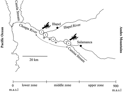
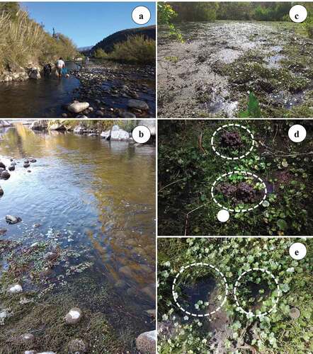
Figure 4. Representative habitat of Parastacus pugnax in the Choapa River Basin. Lotic environment: a) fluvial axis tracked by prawn’s fishers. b) boulders and aquatic macrophytes, including fine sediment in the water. Lentic environment: c) semi-marshland plains bordering the fluvial axis. d) presence of “chimneys” or excavations made on mud deposits around inlets holes to underground galleries. e) inlets holes to underground galleries (white circle).