Figures & data
Figure 1. (a) Map of the Himalaya showing the location the Himalayan accretionary wedge (green), active Himalayan foreland basin (pink), piggyback basins (red). (b) Tectonic map of the Kashmir Himalaya, solid red line indicates Kashmir Basin (KB). (c) Regional geological map of the Kashmir basin and adjoining areas.
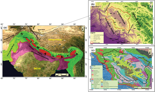
Figure 2. Mountain front Sinuosity (Smf) of different mountain front segments in Kashmir Basin.
Table 1. Calculated geomorphic indices for different sub basins of Kashmir basin.
Figure 3. Hypsometric integral curves of the basins (Where A = total surface of the basin, a = surface area within the basin above a given elevation h and H = highest elevation of the basin).
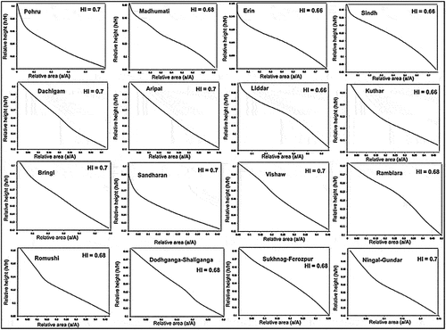
Figure 4. Continued.
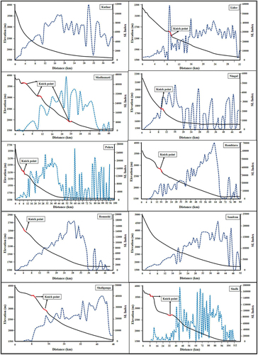
Figure 4. Longitudinal profiles and SL of Aripal, Bringi, Dachigam, Doodhganga, Erin, Ferozpor, Gondar, Kuthar, Lider, Madhumati, Ningal, Rambiara, Romushi, Pohru, Sindh, Sandran, Veshaw, Shaliganga, Sukhnag, Vijay-Dhakil rivers.
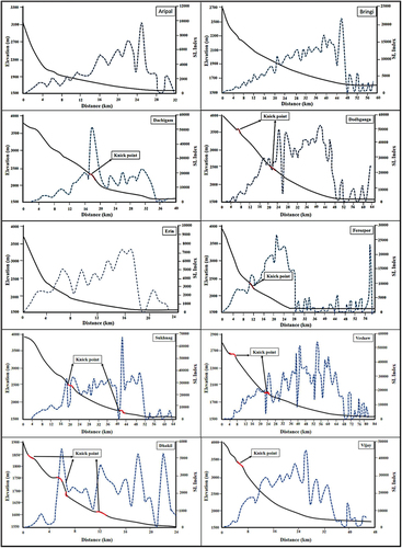
Figure 5. Topographic symmetry factor (T) (where Dd = is the distance between the mid-line and the main river and Da = is the distance between the mid-line and the boundary of the drainage basin).
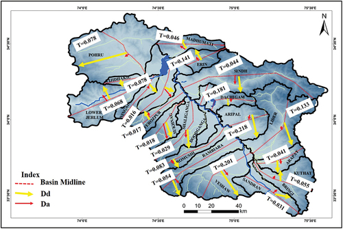
Figure 6. Observed different types of drainage patterns in the Kashmir basin.
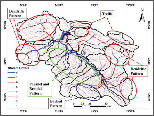
Figure 7. (a, b) Showing drainage modifications by Balapur fault and Raithan Fault along the southern portion of Kashmir basin. Beheaded streams, offset drainage and emergence of new streams are observed along the strike of the faults. (c) Showing traces of Baramulla-Loridor fault (Ahmad et al., Citation2014) or Hayatpor-vatnu fault (Ahmad et al., Citation2015) and deflection in drainage produced by the fault.
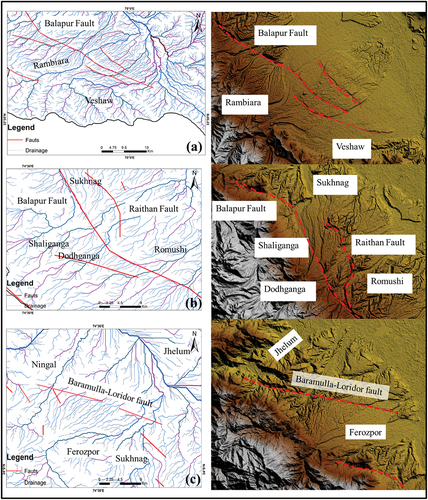
Figure 8. (a) Lineament map of Kashmir Basin. Inset shows that the orientation of the lineaments using rose diagram analysis. (b) Showing the relation between actual fault traces with the determined lineament map of Kashmir basin. The lineaments mostly follow the trend and orientation of the faults present within this region.
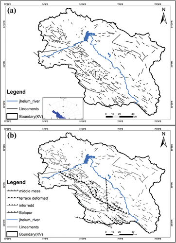
Figure 9. Different folded structures observed on the Greater Himalayan side of the basin. (a) represent the large primary folded (F1) with superimposed secondary folded structures, (b) large scale folded limbs formed of alternating beds of Triassic limestone, Phyllites, Siltstone etc., (c) Intensively folded rock formations branching as Y shaped folded, and (d) small scale folds formed in phyletic rocks consisting small quartz veins representing folding at microscopic level.
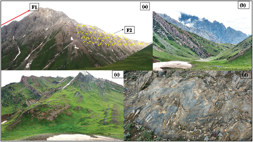
Figure 10. The folded rock sequences along the northern front of the Kashmir Basin. (a) Wular syncline (b) Intensively folded rock sequences at Mansbal area.
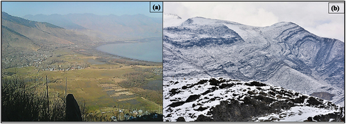
Figure 11. Intensively deformed rock formations on the southern front of Kashmir basin. (a) MCT exposure in Uri Kashmir, contact between green schist and marble (b) tightly folded and refolded Limestones, (c and d) large scale folded interbedded red sandstone and limestone at Uri Baramulla close to MCT.
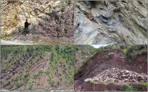
Figure 12. Shows abandoned river channels. (a) Abandoned river bed utilized for residential purposes, (b) Original channel filled with sidewall material and new river course cut across less resistant rocks, (c) Abandoned channel filled with boulders and new stream flowing direction and (d) shows a paleo-channel filled with river bed deposits.
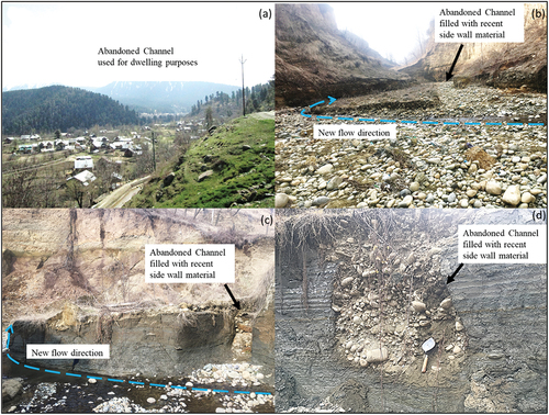
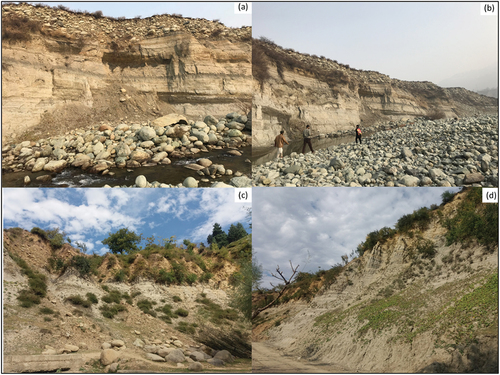
Figure 13. Presence of different unpaired terraces (a) Jhelum river Uri (b) Erin at Bandipora (c) Shaliganga river Budgam and (d) Rambiara river Shopian. The absence of equivalent paired terraces suggest basin tilting and higher structural control.
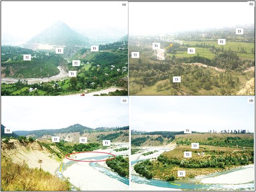
Figure 14. Deeply incised valleys formed due to higher vertical erosion in planar areas. Note the occurrence of landslides along these steep cliffs due to basal erosion of river banks.
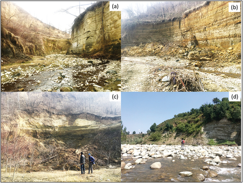
Figure 15. Strath terraces (a) and (b)Rambiara river Shopian (c) Doodhganga river Budgam and (d) Shaliganga river Budgam.