Figures & data
Table I. Comparison of the three study sites (Nicoll & Langrand Citation1989; Garbutt Citation1999; Dolch Citation2003; McConnell & Sweeney Citation2005; Ratsimbasafy et al. Citation2008; Mittermeier et al. Citation2010).
Table II. This table reports site name, code of the indri group, years of sampling, total number of sampling days, total number of waypoints recorded, observation: mean duration of daily observation in hours N ind: number of individuals composing the group according to year. The italic codes represent data sets that we did not utilize for quantitative territory size estimates.
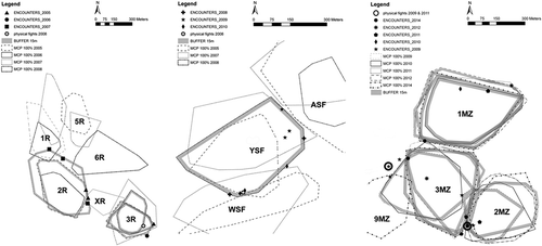
Figure 1. Annual territories of the 16 indri groups in each site: six groups in the Analamazaotra Special Reserve, three groups in the Mitsinjo Station Forestière, and seven groups in the Maromizaha forest. Polygons represent the minimum convex polygons (MCPs) at 100%. The legend box identifies the different lines used to draw annual MCP, allowing the relative location of groups’ territory in the same year, as well as the area occupied by a group through the years, to be distinguished.
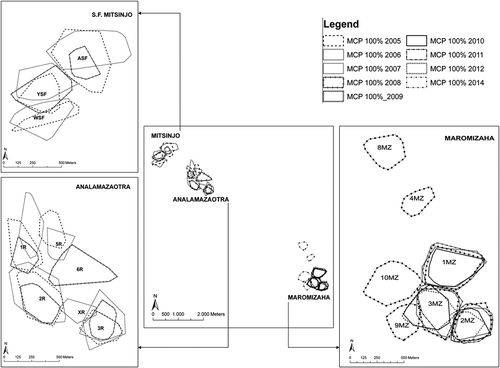
Table III. Group codes and relative year of sampling of the seven data sets used to compare different estimate methods of the territory size: MCP, size corresponding to the MCP100% built including the total number of sampling days per each year; MCPr, size obtained by randomization of daily data sets with a minimum of three waypoints; MCPi, size made up to 100% starting from the size obtained with MCPr at 8 days corresponding on average to 74% of total coverage; MCPd, size made up to 100% starting from size simulated at 16 days of sampling, corresponding on average at 92% of total territory size. We reported the percentage difference between territory size obtained with MCP and the size simulated with the methods MCPr, MCPi and MCPd. Mean and SD are also indicated.
Table IV. reports codes of indri groups; year of sampling; total annual number of sampling days; total number of sampling days with a minimum of three waypoints; territory size estimates using Minimum Convex Polygon (MCP) 100% (ha), (*) estimates corresponding to MCPd (see also ) applied when N days of data set was lower than 16; boundary length (BL); and group size for each year.
Figure 2. The ranging pattern of the group YSF (Mitsinjo Station Forestière) in 2008. We show the daily travel paths of the group YSF during 13 consecutive days (except for missing data of day 12). The group YSF travelled from the core of the territory to the northeastern boundary (from day 2) and then moved to the southwest (from day 8). The group covered the whole territory over 13 days.
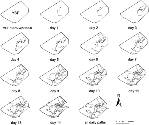
Figure 3. Intergroup encounters observed from 2005 to 2014 in the three sites. Different symbols represent the encounter locations and minimum convex polygons (MCPs) according to the year. The grey shaded buffers represent the 15 m wide area of the annual territorial boundaries (we highlighted the MCP boundary only for the years in which we recorded an encounter).