Figures & data
Figure 1. Summary of study design for assessing differences in waste indicators between urban areas with and without Google Street View coverage.
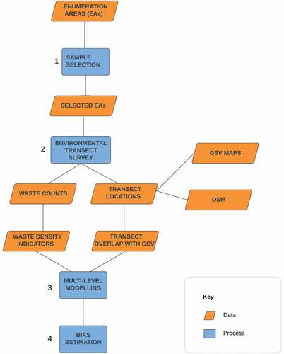
Figure 2. Metropolises with populations over 300,000 in 2020 in low- and middle-income sub-Saharan African countries where Google Street View imagery is available (sources: city populations: UN Habitat Global Database of Metropolises 2020, country boundaries: Planet; World Bank country classification, 2021; (Google, Citation2023)).
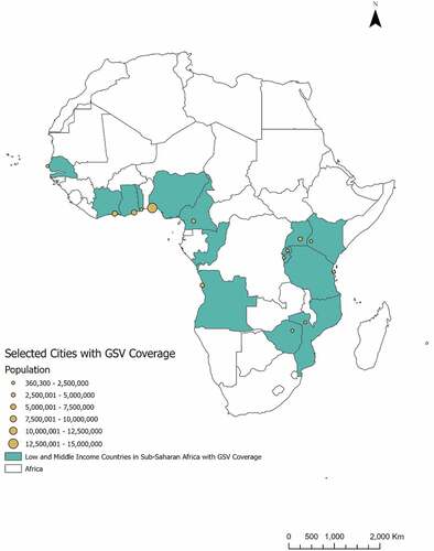
Figure 3. (a) Locations and 2022 Google Street View coverage of environmental transects in Kisumu, Kenya. (b) Inset map showing transects in three case study enumeration areas.
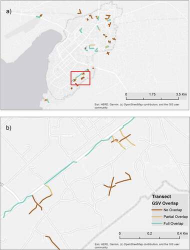
Figure 4. (a) Locations and 2022 Google Street View coverage of environmental transects in Greater Accra, Ghana. (b) Inset map showing transects in two case study enumeration areas
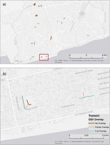
Table 1. Summary statistics describing characteristics of environmental transects with different levels of GSV overlap in Kisumu and Greater Accra (OSM: OpenStreetMap)
Figure 5. Distribution of (a) waste burning density and (b) scattered waste density for transects in Greater Accra and Kisumu with full, partial, or no Google Street View coverage
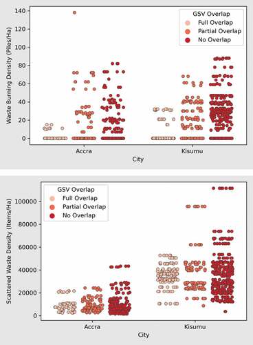
Table 2. Coefficients for transects with full and partial Google Street View, derived from a multi-level model predicting six environmental waste indicators in Kisumu, Kenya (based on 126 observations of transects with full GSV coverage, 114 observations of transects with partial GSV coverage, and 346 observations of transects with no GSV coverage; reference category: no GSV coverage)
Table 3. Coefficients for transects with full and partial Google Street View, derived from a multi-level model predicting six environmental waste indicators in Greater Accra, Ghana (based on 56 observations of transects with full GSV coverage, 103 observations of transects with partial GSV coverage, and 200 observations of transects with no GSV coverage; reference category: no GSV coverage)
Data availability statement
For the Greater Accra and Kisumu analysis, the environmental transect data are openly available as:
Umar, F., Amponsah, M., Damkjaer, S. Dzodzomenyo, M., Okotto, L.G., Okotto-Okotto, J., Oigo, J., Shaw, P., Wright, J, and Väisänen, H., Wanza, P. (2023). Environmental Transects Surveys of Mismanaged Waste in Off-Grid Neighbourhoods of Kisumu, Kenya, and Greater Accra, Ghana, 2021 [Data Collection]. Colchester, Essex: UK Data Service. https://dx.doi.org/10.5255/UKDA-SN-856145.
OpenStreetMap data are openly available from multiple sources, including Planet: https://planet.openstreetmap.org/.
For the analysis of dry season bias, the UN Habitat Global State of Metropoles Database 2020 is openly available via https://urbanpolicyplatform.org/global-state-of-metropolis/. The World Bank country classification is openly available here: https://datatopics.worldbank.org/world-development-indicators/the-world-by-income-and-region.html. CHIRPS rainfall data are openly available here: https://www.chc.ucsb.edu/data/chirps. Country boundaries are openly available from: https://www.naturalearthdata.com/about/terms-of-use/.