Figures & data
Figure 1. Location of the 15 focal landscapes in the study area. Inset maps show location in south-central Chile (a) and in Araucanía region (b). Each focal landscape is depicted by circles of 3.141 km2 each, and farms are classified according to different cultural groups (Mapuche, Chilean, Foreigner); “Other” category refers to any other type of property that does not account as an agricultural farm, e.g. forest plantation or natural conservation areas, school, etc. Coordinates according to WGS84.
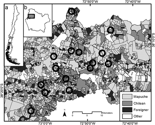
Figure 2. (a) Proportion of agricultural area for each cultural group (Indigenous Mapuche, Chilean, Foreigner) and (b) Agrobiodiversity index (AI) for each cultural group (Mapuche, Chilean, Foreigner), at each focal landscape (n = 15) in Araucanía region, south-central Chile. Horizontal lines represent the mean values ± SD. Significant differences (p < 0.1) are denoted by different letters (Dunn’s test).
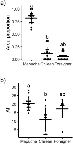
Table 1. Characterization of agrobiodiversity on each focal landscape (n = 15) for each cultural group (Mapuche, Chilean and Foreigner) at Araucanía region, in south-central Chile. The data were obtained from a survey questionnaire. See Supplementary Table 1 for more details on farm characterization
Figure 3. Relationship between total agrobiodiversity index (TA) and (a) cultural diversity index, and (b) cultural dominance index at each focal landscape (n = 15) in Araucanía region, south-central Chile. For visual purposes, a solid line shows fitted linear regressions.
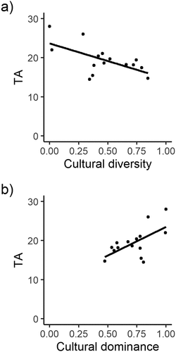
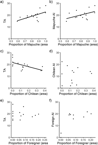
Figure 4. On the left panel, relationship between Total Agrobiodiversity index (TA) and proportional area occupied by (a) Mapuche, (c) Chilean and (e) Foreigner cultural groups. On the right panel, relationship between Agrobiodiversity index (AI) and proportional area occupied by (a) Mapuche, (c) Chilean and (e) Foreigner cultural groups. A solid line shows fitted linear regressions. Note the differences in x-axis scales among plots.