Figures & data
Figure 1 Location map of the study area and the soil sampling sites in southern China.
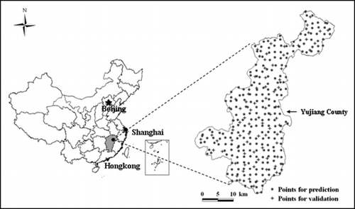
Table 1 Soil organic carbon content (g kg−1) statistics for various soil types, land uses and land use–soil types
Figure 2 Soil (at the family level) and land use of the study area. The 10 families belong to two great groups including paddy soil (Anthrosols, WRB) and red soil (Acrisols, WRB), and three subgroups including Hydromorphic (Hydragric Anthrosols, WRB), Gleyed (Gleyic-Hydragic Anthrosols, WRB) and Red soil (Acrisols, WRB), which are abbreviated as PH, PG and RR. Soil families are classified mainly according to parent materials. A, B, C, D and E are labels for the following parent materials, alluvium, sandy conglomerate, quaternary red clay, shale and red sandstone, respectively.
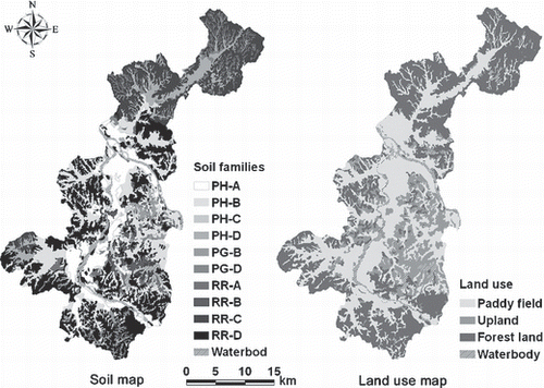
Figure 3 Histograms of (a) soil organic carbon original data, (b) the residuals by removing the mean values of soil type, (c) land use and (d) land use–soil type.
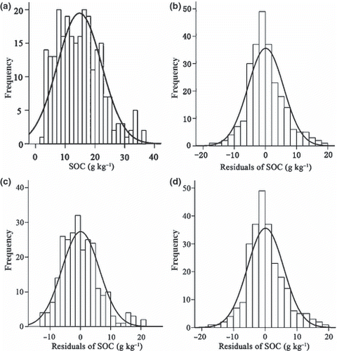
Table 2 Best-fit semivariogram models and their parameters for the various prediction approaches
Figure 4 Semivariograms of the studied interpolation approaches (a, b, c and d are for ordinary kriging [OK], kriging combined with soil-type information [KST], land use [KLU] and combined land use–soil type information [KLUST], respectively).
![Figure 4 Semivariograms of the studied interpolation approaches (a, b, c and d are for ordinary kriging [OK], kriging combined with soil-type information [KST], land use [KLU] and combined land use–soil type information [KLUST], respectively).](/cms/asset/a5282633-3f53-451c-99b7-c7ba073b17e6/tssp_a_10382797_o_f0004g.gif)
Figure 5 Relationship between the predicted and observed soil organic content from the interpolation methods (a, b, c, and d are for ordinary kriging [OK], kriging combined with soil-type information [KST], land use [KLU] and combined land use–soil type information [KLUST], respectively).
![Figure 5 Relationship between the predicted and observed soil organic content from the interpolation methods (a, b, c, and d are for ordinary kriging [OK], kriging combined with soil-type information [KST], land use [KLU] and combined land use–soil type information [KLUST], respectively).](/cms/asset/0ca35a3c-b191-4019-a69c-8530abc0c959/tssp_a_10382797_o_f0005g.gif)
Figure 6 Comparison of the root mean square error (RMSE) associated with the application of different kriging interpolations in paddy and red soils.
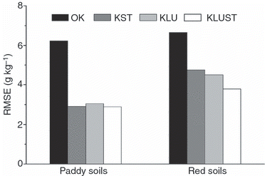
Figure 7 Comparison of the root mean square error (RMSE) associated with the application of different kriging interpolations by land-use group.
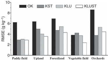
Figure 8 Soil organic carbon (SOC) distribution maps generated from the four kriging approaches (a, b, c, and d are for ordinary kriging [OK], kriging combined with soil-type information [KST], land use [KLU] and combined land use–soil type information [KLUST], respectively).
![Figure 8 Soil organic carbon (SOC) distribution maps generated from the four kriging approaches (a, b, c, and d are for ordinary kriging [OK], kriging combined with soil-type information [KST], land use [KLU] and combined land use–soil type information [KLUST], respectively).](/cms/asset/3bd0c2d9-7dde-4500-9ae5-c1fdce405211/tssp_a_10382797_o_f0008g.gif)