Figures & data
Figure 1 Seasonal variation in air temperature and precipitation in Yakutsk. Open and closed circles indicate the average air temperature for each month over 30 years and in 2004, respectively. Open and closed bars indicate the average precipitation for each month over 30 years and the amount of precipitation for each month in 2004, respectively.
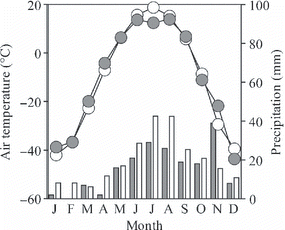
Figure 2 Location map of the study site and the layout of the measurement plots. Microbial respiration in the whole soil was measured in the trenched plots. Fluxes and concentrations of greenhouse gases in soil air were measured near the trenched plots.
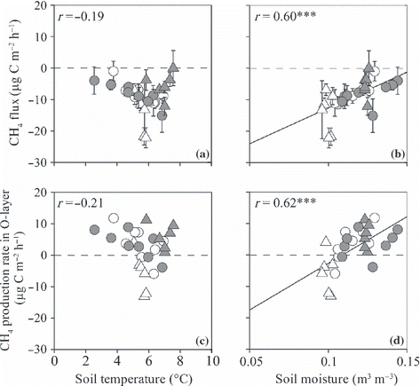
Table 1 Soil physical and chemical properties at the study site
Figure 3 Effect of soil air-filled pore space on the measured gas tortuosity factor (diffusivity relative to that for still air). The different symbols distinguish measurements on soil cores from different layers.
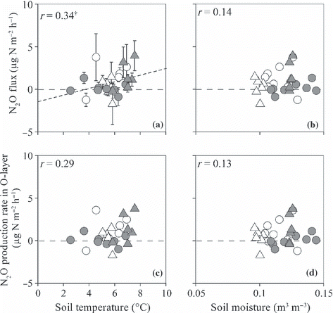
Figure 4 (a,b) Temporal variation in soil temperature at 10, 30, 40 and 60 cm depths (T10, T30, T40, and T60, respectively) and (c,d) soil moisture at 0–10, 10–20, 20–30, 30–40 and 50–60 cm depths (W10, W20, W30, W40, and W60, respectively) of the non-irrigated (a,c) and irrigated plots (b,d). Arrows indicate the irrigation events for the irrigated plot. Open bars represent the precipitation amount.
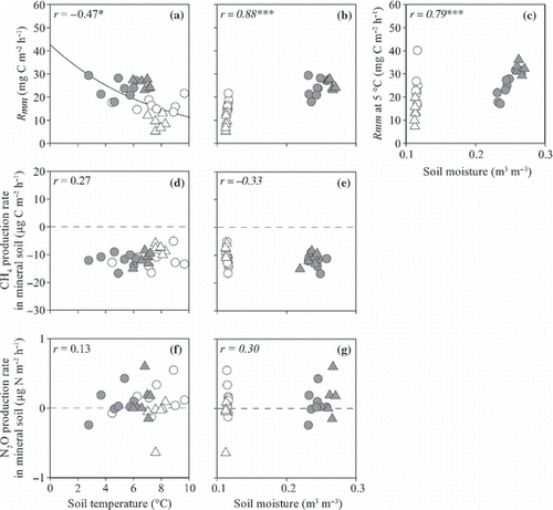
Table 2 Average greenhouse gas fluxes, production, global warming potentials and soil temperature and moisture during each period of measurement
Figure 5 Temporal variation in (a) CO2 fluxes from the surface of the O-layer (Rs), (b) microbial respiration from the surface of the O-layer (Rmw) and (c) root respiration (Rr). Open symbols indicate data from the non-irrigated plot and closed symbols indicate data from the irrigated plot. Vertical bars denote the standard error of each parameter. Arrows indicate the irrigation events for the irrigated plot.
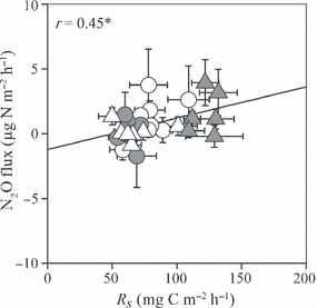
Figure 6 Temporal variation in (a) CH4 fluxes from the surface of the O-layer and (b) N2O fluxes from the surface of the O-layer of the non-irrigated (open symbols) and irrigated plots (closed symbols). Positive values indicate net emission and negative values indicate net consumption. Vertical bars denote the standard error of each parameter. Arrows indicate the irrigation events for the irrigated plot.
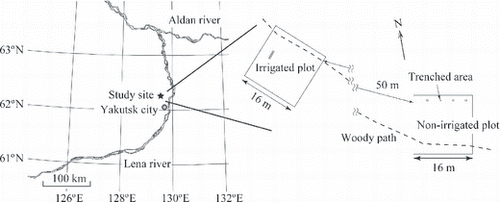
Figure 7 Temporal variation in (a,b) CO2, (c,d) CH4 and (e,f) N2O concentrations (conc.) in soil air at 10, 20, 30 and 50 cm depths of the non-irrigated (a,c,e) and irrigated plots (b,d,f). Data from 10, 20, 30 and 50 cm depths are indicated by open circles, closed circles, open triangles and closed triangles, respectively. Arrows indicate the irrigation events for the irrigated plot.
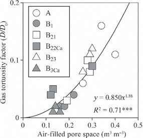
Figure 8 Temporal variation in (a) microbial respiration rate in the O-layer and the mineral soil (Rmo are indicated by circles and Rmm are indicated by triangles, (b) CH4 production rates in the O-layer and the mineral soil (circles and triangles, respectively) and (c) N2O production rates in the O-layer and the mineral soil (circles and triangles, respectively) of the non-irrigated (open symbols) and irrigated plots (closed symbols). Positive values indicate net emission and negative values indicate net consumption. Arrows indicate the irrigation events for the irrigated plot.
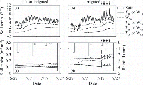
Table 3 Average global warming potentials of root respiration (Rr), microbial respiration in the O-layer (Rmo), microbial respiration in the mineral soil (Rmm), and CH4 and N2O production of each part of the soil in each period (expressed in CO2-equivalent; mg CO2-eq m−2 h−1) from the study site
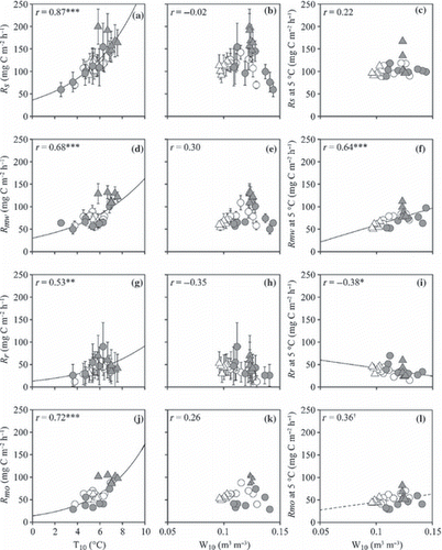
Figure 9 (a,b) CO2 fluxes from the surface of the O-layer (Rs), (d,e) respiration from the surface of the O-layer (Rmw), (g,h) root respiration (Rr), (j,k) microbial respiration rate in the O-layer (Rmo) and (c,f,i,l) normalized Rs, Rmw, Rr and Rmo plotted against soil temperature at a depth of 10 cm (a,d,g,j) and moisture at the 0–10 cm depth (b,c,e,f,h,i,k,l). Open and closed circles indicate data from the non-irrigated and irrigated plots before irrigation and open and closed triangles indicate data from non-irrigated and irrigated plots during irrigation. †P < 0.1; *P ≤ 0.05; **P < 0.01; ***P < 0.001. Error bars indicate the standard error of each parameter.
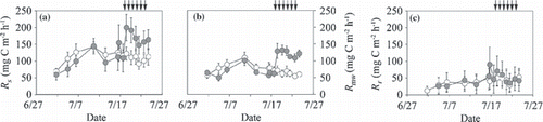
Figure 10 (a,b) CH4 fluxes from the surface of the O-layer and (c,d) the CH4 production rate in the O-layer plotted against soil temperature at a depth of 10 cm (a,c) and moisture at the 0–10 cm depth (b,d). Open and closed circles indicate data from non-irrigated and irrigated plots before irrigation and open and closed triangles indicate data from non-irrigated and irrigated plots during irrigation. ***P < 0.001. Error bars indicate the standard error of each parameter.
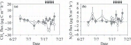
Figure 11 (a,b) N2O fluxes from the surface of the O-layer and (c,d) the N2O production rate in the O-layer plotted against soil temperature at a depth of 10 cm (a,c) and moisture at the 0–10 cm depth (b,d). Open and closed circles indicate data from non-irrigated and irrigated plots before irrigation and open and closed triangles indicate data from non-irrigated and irrigated plots during irrigation. †P < 0.1. Error bars indicate the standard error of each parameter.
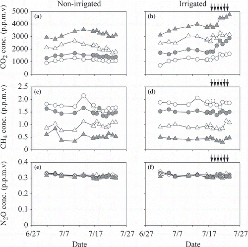
Figure 12 (a,b) Microbial respiration rate in mineral soil and (c,d) CH4 and (e,f) N2O production rates in mineral soil plotted against soil temperature at a depth of 10 cm (a,c,e) and moisture at the 0–10 cm depth (b,d,f). Open and closed circles indicate data from non-irrigated and irrigated plots before irrigation and open and closed triangles indicate data from non-irrigated and irrigated plots during irrigation. ***P < 0.001. The coefficient values written in italics were calculated using Spearman’s correlation analysis.
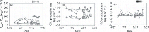
Figure 13 CO2 fluxes from the surface of the O-layer (Rs) plotted against N2O fluxes from the surface of the O-layer. Open and closed circles indicate data from non-irrigated and irrigated plots before irrigation and open and closed triangles indicate data from non-irrigated and irrigated plots during irrigation. *P < 0.05. Vertical and horizontal bars denote the standard error of the Rs and N2O fluxes, respectively.