1,693
Views
1
CrossRef citations to date
0
Altmetric
Original Articles

Google Earth and sustainable development education: examples from human and physical geography

, , &
Pages 8-14 | Published online: 15 Dec 2015

Figures & data

Figure 1: Screen shot taken from Google Earth of eastern margins of Nouakchott, illustrating sustainable planting regimes, with inset diagram of dune processes. Source Google Earth (2010) and CitationHaslett (2008).

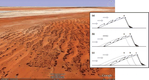
Table 1: Results of the student survey following the exercise.

Table 2: Responses to The Sands of Time resource from MA ESDGC students.

Figure 2: Collapsed structures, Port Au Prince. Image source Google Earth, 2010, data source: GEO-CAN Network 2010.

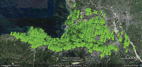
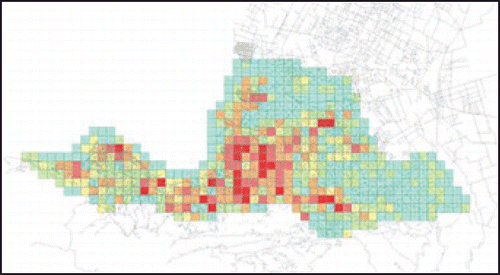
Figure 3: Number of collapsed structures per 0.5km × 0.5km tile. Source: ImageCat 2010.

Reprints and Corporate Permissions

Please note: Selecting permissions does not provide access to the full text of the article, please see our help page How do I view content?

To request a reprint or corporate permissions for this article, please click on the relevant link below:

Academic Permissions

Please note: Selecting permissions does not provide access to the full text of the article, please see our help page How do I view content?

Obtain permissions instantly via Rightslink by clicking on the button below:

If you are unable to obtain permissions via Rightslink, please complete and submit this Permissions form. For more information, please visit our Permissions help page.