Figures & data
FIGURE 1 Photograph of the north-facing Teardrop Glacier with arrow indicating the study area and map of Sverdrup Pass in central Ellesmere Island (79°10′N, 79°45′W), Nunavut. The lighter colored terrain visible in the photograph to the left of the glacier shows the lichen ‘trim line’ and the extent of glacier melt since the end of the last Little Ice Age.
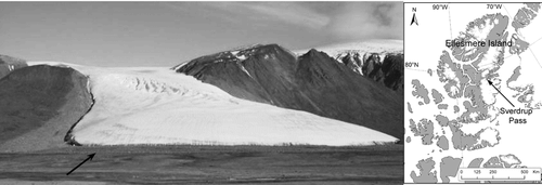
FIGURE 2 Photographs of the glacier foreland at various distances and the associated dominant vascular plant species in percent cover and frequency; (a) 5–10 m from the glacier, scattered individuals of Alopecurus borealis, Papaver radicatum, Saxifraga cernua, Saxifraga rivularis, and Draba oblongata; (b) 25–30 m from the glacier, Luzula confusa, Saxifraga oppositifolia, Stellaria longipes, Alopecurus borealis, and Saxifraga cernua; (c) 170 m from the glacier, Salix arctica, Saxifraga oppositifolia, Luzula confusa, Luzula arctica, and Dryas integrifolia. The end of the boulder field and foreland at 190 m is visible to the right of .
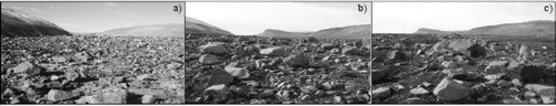
FIGURE 3 Location of the microclimate (Met) and sampling sites, the classification groups derived from divisive classification analysis of the vascular plant cover, and approximate terrain ages along the Teardrop Glacier foreland, Sverdrup Pass, Ellesmere Island, Nunavut. Modified from CitationBreen and Lévesque (2006).
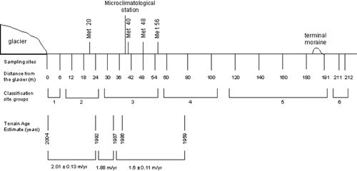
FIGURE 4 Samples of biological soil crust (left) and glacial soil (right) from the Teardrop Glacier foreland, Sverdrup Pass, Ellesmere Island, Nunavut.
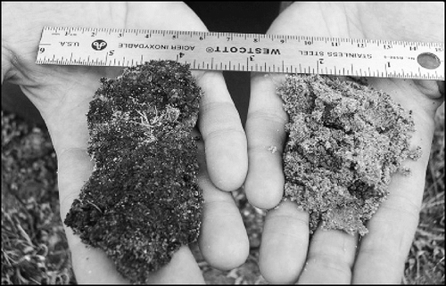
FIGURE 5 Daily mean temperatures of ambient air (1.5 m above surface), boundary air layer (10 cm above surface) and soil surface (1 cm below surface) at the microclimate station, 40 m from the Teardrop Glacier, Sverdrup Pass, Ellesmere Island, Nunavut from 3 July to 7 August 2004.
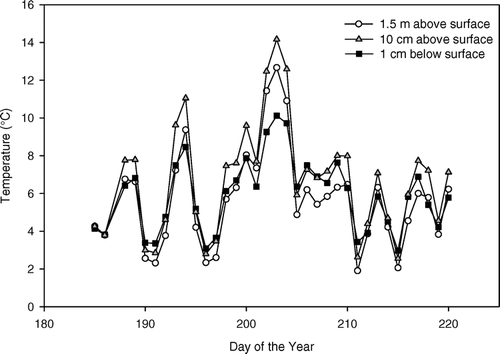
FIGURE 6 Daily mean temperature (°C) of crusted and uncrusted surfaces (∼1 cm deep) at each of the four microclimate sites at 20, 40, 48 and 56 m from the Teardrop Glacier, Sverdrup Pass, Ellesmere Island, Nunavut from 3 July to 7 August 2004.
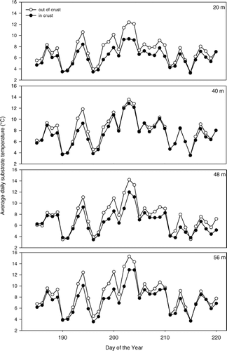
TABLE 1 Thawing degree-days (TDD) in and out of crusted soil surfaces (∼1 cm deep) in front of the Teardrop Glacier, Sverdrup Pass, Ellesmere Island. July TDD are calculated from 3 July to 3 August 2004.
FIGURE 7 Daily mean percent volumetric water content (from TDR) in and out of crust (∼1 cm deep) at two microclimate sites at 20 and 56 m from the Teardrop Glacier, Sverdrup Pass, Ellesmere Island, Nunavut, from 3 July to 7 August 2004.
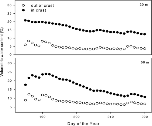
FIGURE 8 Mean crust cover (%) ± SE and thickness (mean ± SE of the five thickest crusts) for each classification group with distance from the Teardrop Glacier, Sverdrup Pass, Ellesmere Island, Nunavut. Classification groups are averaged from 18 site values in sequential order: Group 2 (n = 3), 3 (n = 5), 4 (n = 3), 5 (n = 5), 6 (n = 2).
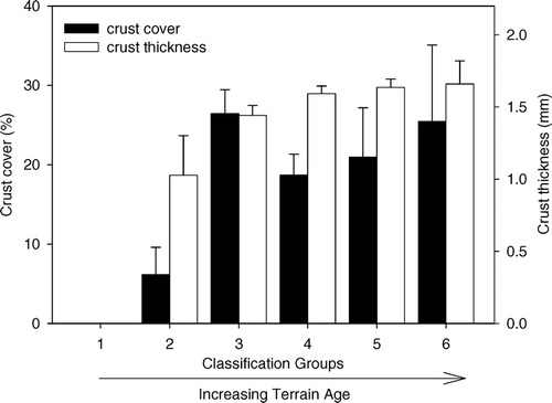
FIGURE 9 (a) Volumetric water content and (b) bulk density of crusted surface samples (0.7 cm deep) and soil cores (5 cm deep) for each classification group with distance from the Teardrop Glacier, Sverdrup Pass, Ellesmere Island, Nunavut. Classification Groups are averaged from 18 site values in sequential order: Group 2 (n = 3), 3 (n = 5), 4 (n = 3), 5 (n = 5), 6 (n = 2). p-values note significance across classification groups. Letters denote results of multiple comparison tests. Groups with the same letters were not significantly different from each other.
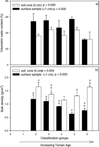
FIGURE 10 Mean nutrient concentrations and pH values of the <2 mm soil fraction from surface samples (0.7 cm deep) and soil cores (5 cm deep) for each classification group with distance from the Teardrop Glacier, Sverdrup Pass, Ellesmere Island, Nunavut. The dashed horizontal lines are mean values from CitationLévesque (1997) and CitationLévesque et al. (1997). Classification Groups are averaged from 18 site values in sequential order: Group 2 (n = 3), 3 (n = 5), 4 (n = 3), 5 (n = 5), 6 (n = 2). p-values note significance across classification groups. Letters denote results of multiple comparison tests. Groups with the same letters were not significantly different from each other.
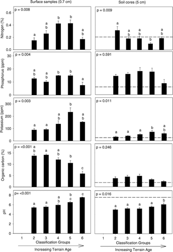
TABLE 2 Soil characteristics (mean ± SE) of variables from surface samples (∼1 cm deep) collected in and out of crust at each of the four microclimate sites in front of the Teardrop Glacier, Sverdrup Pass, Ellesmere Island, Nunavut. Significance of difference in and out of crust * p < 0.05, ** p ≤ 0.01, *** p ≤ 0.001. Samples are analyzed from the fine soil fraction (<2 mm).