Figures & data
Figure 1 (a) Map of the Niwot Ridge area and insets of the study sites “Martinelli Snowfield” (b), “Niwot Trough” (c), and “Fahey” (d). Map base for contour lines (ft), lakes, and peaks is the Ward (1978) 7.5′ Quadrangle. Inset of Martinelli Snowfield (b) shows seismic refraction line SSR V and numbered bullets indicate the location of borings adjacent to the line and north of the trail to the Green Lakes. Inset of Niwot Trough (c) shows location of four seismic refraction lines Niwot SSR I–IV beside the trail to Niwot Ridge. Inset of Fahey site (d) north of the trail to the Tundra Laboratory at Niwot Ridge shows GPR lines I–V; bullets numbered 1 and 2 indicate the location of borings.
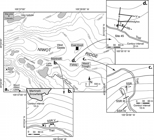
Figure 2 Final stratigraphic model for the Martinelli Snowfield site, showing materials, layering, and graphic logs from borings adjacent to the seismic line together with the numbers of seismic layers. Inset image shows a shallow subsurface section at a road cut 40 m downhill from the seismic line. Note that fine unconsolidated eolian material caps periglacial slope deposits. Calculated seismic velocities and their interpretation are listed in and in Appendix A.
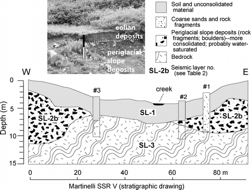
Figure 3 Fence diagram showing the stratigraphic model for lines Niwot I, II, III, and IV at the Niwot Trough site together with the numbers of seismic layers. Calculated seismic velocities and their interpretation are listed in and in Appendix A.
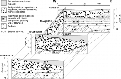
Figure 4 Velocity analysis of FAH-CMP I and FAH-CMP II lines. Subsurface velocity can be determined from CMP surveys which produce distance vs. travel time plots. Analysis of the hyperbola allows the calculation of subsurface velocity. (a) 1-D velocity model showing the calculated velocity (m ns−1) with depth. (b) CMP solution showing linear dispersal of the ground wave from top left to upper right side and hyperbolic reflection events deeper in the section. (c) Semblance plot with picks of root-mean-square velocity marked with black crosses and white circles.
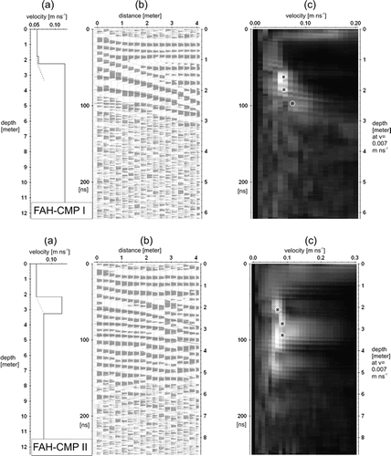
Figure 5 100 MHz GPR lines of Fahey 100 I–V, showing two way travel-time (TWT) on the left axis, and a time to depth conversion on the right axis. The images are characterized by many hyperbolic diffractions (probably small boulders) and areas with reduced signal penetration noted with dashed lines and double points. Note parallel to subparallel reflections which are characteristic for sediments that have been transported down slope by periglacial processes.
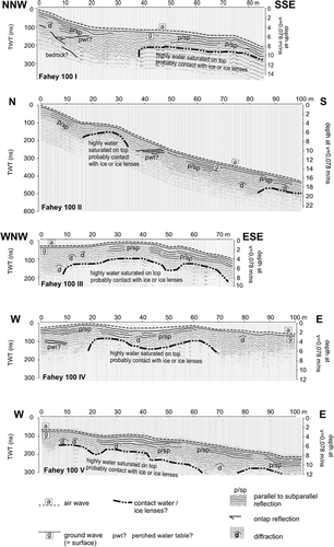
Figure 6 Sketch map of Fahey site showing the location of measured lines and the sites of CMP measurements together with the general distribution of the solifluction lobes. Gray shading highlights areas possibly underlain by ice lenses in the shallow subsurface. Profiles and the layer descriptions are derived from GPR images and velocity analysis. Grayish black circles show the location of CMP survey. CMP I is on the solifluction lobe, whereas CMP II is on the dry area west of the lobe. Open bullets show location of two boreholes, one on the solifluction lobe and the other at the edge of the lobe. Generalized lithogenic sketches and descriptions (modified from field log of Tingjun Zhang) interpreted from borings. Holes were drilled two months after the GPR survey using an air compressor technique which allows only general description of the lithogenic subsurface material (K. Chowanski, INSTAAR, personal communication, 2006).
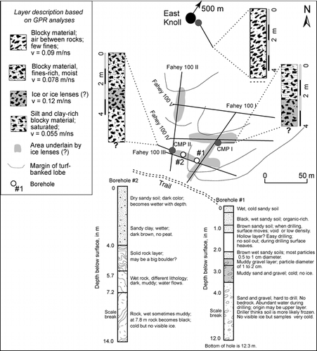
Figure 7 Schematic cross section at Niwot Ridge portraying the composition of the shallow subsurface, lateral thickness variation, and local variation in moisture and ice content over a downslope distance of approximately 800 m. Vertical exaggeration is approximately four times. The image summarizes data acquired by our SSR and GPR studies, modified by data from drill cores, outcrops, and previous studies.
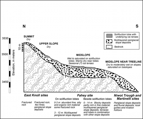
Table A1 Summary of field settings and calculated values for shallow seismic refraction (SSR) lines collected in the vicinity of Niwot Ridge. The total calculated time difference measures the average between measured and calculated travel time for each line, based on the network-raytracing method.
Table A2 Overview of different layers (seismic layer = SL) interpreted from SSR models for sites at Niwot Ridge and near Martinelli Snowfield. For each modeled layer the velocity range and interpretation are noted as well as the depth to bedrock, which here is the seismic layer SL-3.
Table A3 Sequence of processing steps applied to each ground penetrating radar (GPR) line using the software ReflexW.
Table A4 Summary of field settings and calculated values for ground penetrating radar (GPR) lines collected in the vicinity of Niwot Ridge ().