Figures & data
FIGURE 1 Map showing the distribution of loess in Alaska (adapted from CitationHopkins, 1963, for the Seward Peninsula and CitationPéwé, 1975, for the rest of the state) and localities studied. Abbreviations: HH, Halfway House; EC, Eva Creek; CH, Chena Hot Springs Road; BH, Birch Hill; GH, Gold Hill.
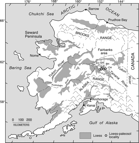
FIGURE 2 Map showing the surficial geology of the Fairbanks area and locations of sites where stratigraphic studies were conducted. Geology from CitationPéwé et al. (1966). HH, Halfway House; EC, Eva Creek; GH, Gold Hill; BH, Birch Hill; CH, Chena Hot Springs Road.
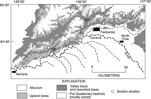
TABLE 1 Accelerator mass spectrometric (AMS) radiocarbon ages of humic acid extractions, charcoal and macrofossils from central Alaskan loess.
FIGURE 3 Loess stratigraphy, radiocarbon ages, and possible correlations at the Eva Creek (lower) section. Stratigraphy of the section from 1900 to 2200 cm is generalized from CitationMuhs et al. (2001a). Gray shades mark paleosols. Fission-track age estimate for the Old Crow tephra is from CitationWestgate et al. (1990). Black-filled circles are approximate calibrated radiocarbon ages of charcoal or macrofossils; gray-filled circles are approximate calibrated radiocarbon ages of humic acid extractions from paleosols (see text for discussion). Also shown are plots of Na2O/TiO2, and SiO2/TiO2, CaO/TiO2, and MgO/TiO2 in the section.
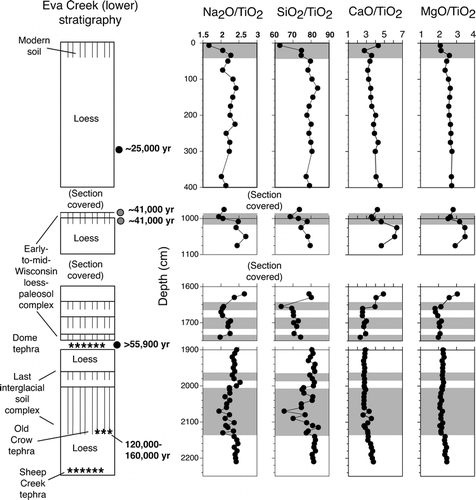
FIGURE 4 Loess stratigraphy, radiocarbon ages, selected 10Be age estimates, and possible correlations (CitationMuhs et al., 2003a) at the Halfway House section; fission-track age estimate for the Old Crow tephra is from CitationWestgate et al. (1990). Open circles are 10Be age estimates; black-filled circles are new radiocarbon ages of charcoal (see text for discussion). Also shown are plots of Na2O/TiO2, plagioclase/quartz, SiO2/TiO2, CaO/TiO2, and CaCO3 in the section. Gray shades mark paleosols.
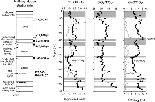
FIGURE 5 Loess stratigraphy, radiocarbon ages, selected 10Be age estimates, and possible correlations (CitationMuhs et al., 2003a) at the Gold Hill section; fission-track age estimate for the PH tephra is from CitationWestgate et al. (1990). Open circles are 10Be age estimates, gray-filled circles are radiocarbon ages of humic acid extractions, black-filled circle is radiocarbon age of charcoal. Also shown are plots of Na2O/TiO2, plagioclase/quartz, SiO2/TiO2, CaO/TiO2, and CaCO3 in the section. Gray shades mark paleosols.
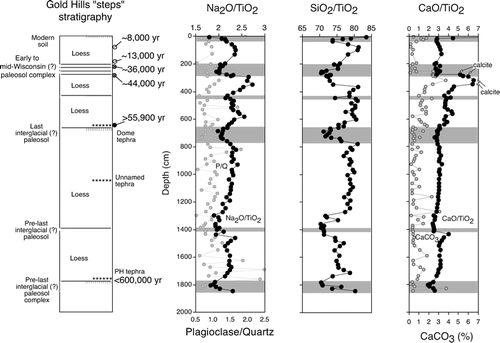
FIGURE 6 Loess stratigraphy, radiocarbon ages, and possible correlations (CitationMuhs et al., 2003a) at the Chena Hot Springs Road section. Gray-filled circles are radiocarbon ages of humic acid extractions, black-filled circles are radiocarbon ages of charcoal. Also shown are plots of Na2O/TiO2, SiO2/TiO2, and CaO/TiO2 in the section. Gray shades mark paleosols.
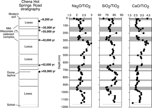
FIGURE 7 Loess stratigraphy, radiocarbon ages, and possible correlations (CitationMuhs et al., 2003a) at the Birch Hill section. Gray-filled circle is radiocarbon age of a humic acid extraction, black-filled circle is a radiocarbon age of charcoal. Also shown are plots of Na2O/TiO2, SiO2/TiO2, and CaO/TiO2 in the section. Gray shades mark paleosols.
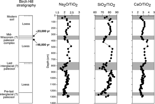
FIGURE 8 Plots of CaO/ZrO2 for the Halfway House, Eva Creek, Gold Hill, Chena Hot Springs Road, and Birch Hill loess sections; hachures represent modern soils and paleosols. Dashed gray lines correlate parts of sections where tephras are found (DT, Dome tephra; OCT, Old Crow tephra; SCT, Sheep Creek tephra). Also shown are ranges of the loess source sediments (silt fractions of the Tanana River, Yukon River, and Nenana River; data from CitationMuhs and Budahn, 2006).
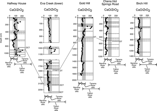
FIGURE 9 X-ray diffraction patterns (glycolated, oriented mounts) of clays from various localities of the Tanana and Yukon Rivers.
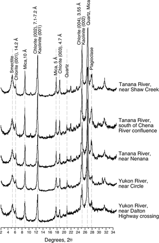
FIGURE 10 X-ray diffraction patterns (glycolated, oriented mounts) of clays from modern soils at the Chena Hot Springs Road and Birch Hill loess sections near Fairbanks.
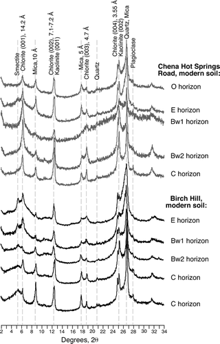
FIGURE 11 X-ray diffraction patterns (glycolated, oriented mounts) of clays from selected soils, paleosols, and loesses from the Halfway House section.
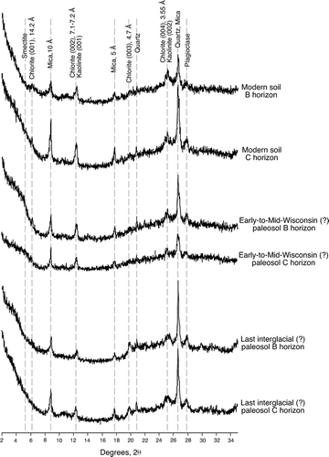
FIGURE 12 X-ray diffraction patterns (glycolated, oriented mounts) of clays from selected soils, paleosols, and loesses from the Gold Hill section.
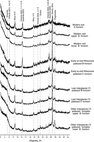
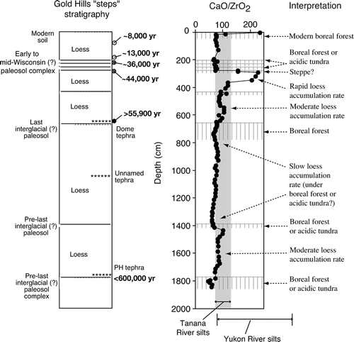
FIGURE 13 Plot of CaO/ZrO2 for the Gold Hill loess section (taken from ) and the ranges of CaO/ZrO2 for the loess source sediments (silt fractions of the Tanana River and Yukon River). Also shown are inferred vegetation types during periods of soil formation and inferred rates of sedimentation during periods of loess accumulation.