1,181
Views
0
CrossRef citations to date
0
Altmetric
Articles

Pollen Evidence for Late Pleistocene Bering Land Bridge Environments from Norton Sound, Northeastern Bering Sea, Alaska

&
Pages 451-461 | Accepted 01 Mar 2008, Published online: 23 Jan 2018

Figures & data

Figure 1 Map of central Beringia, showing extent of Bering land bridge during the late Wisconsin maximum, ∼18,000 14C yr BP. Glacial ice extent is based on CitationKaufman and Hopkins (1986), CitationHamilton (1994), CitationVelichko et al. (1984), and CitationKaufman and Manley (2004). Key sites with pollen evidence for late Wisconsin vegetation discussed in this paper include (1) Kaiyak Lake, northwestern Alaska (CitationAnderson, 1985); (2) Squirrel Lake, northwestern Alaska (CitationAnderson, 1985); (3) Imuruk Lake, Seward Peninsula (CitationColinvaux, 1964; CitationColbaugh, 1968); (4) Core 79-121, Norton Sound (CitationMuhs et al., 2003; this paper); and (5) Zagoskin Lake, St. Michael Island (CitationAger, 1983, Citation2003).
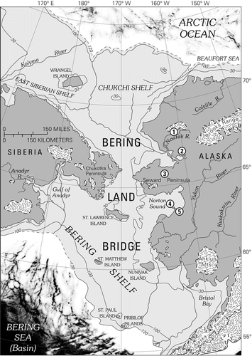
Figure 1 Map of central Beringia, showing extent of Bering land bridge during the late Wisconsin maximum, ∼18,000 14C yr BP. Glacial ice extent is based on CitationKaufman and Hopkins (1986), CitationHamilton (1994), CitationVelichko et al. (1984), and CitationKaufman and Manley (2004). Key sites with pollen evidence for late Wisconsin vegetation discussed in this paper include (1) Kaiyak Lake, northwestern Alaska (CitationAnderson, 1985); (2) Squirrel Lake, northwestern Alaska (CitationAnderson, 1985); (3) Imuruk Lake, Seward Peninsula (CitationColinvaux, 1964; CitationColbaugh, 1968); (4) Core 79-121, Norton Sound (CitationMuhs et al., 2003; this paper); and (5) Zagoskin Lake, St. Michael Island (CitationAger, 1983, Citation2003).

Figure 2 Map of Norton Sound, northeastern Bering Sea, showing bathymetry (CitationSharma, 1979), and distribution of major (modern) vegetation types (CitationJFSLUPCFA, 1973). Also shown are: (1) site of USGS core 76-121; (2) St. Michael Island, site of Puyuk and Zagoskin Lake pollen records (CitationAger, 1982, Citation1983, Citation2003); (3) Village of St. Michael, site of climate data station (see ); (4) Village of Unalakleet, site of climate data station (see ); (5) City of Nome, site of climate data station (see ); (6) Village of Teller, site of climate data station ().
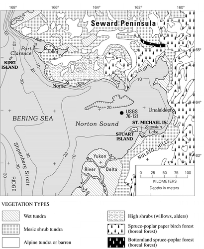
Figure 2 Map of Norton Sound, northeastern Bering Sea, showing bathymetry (CitationSharma, 1979), and distribution of major (modern) vegetation types (CitationJFSLUPCFA, 1973). Also shown are: (1) site of USGS core 76-121; (2) St. Michael Island, site of Puyuk and Zagoskin Lake pollen records (CitationAger, 1982, Citation1983, Citation2003); (3) Village of St. Michael, site of climate data station (see Table 1); (4) Village of Unalakleet, site of climate data station (see Table 1); (5) City of Nome, site of climate data station (see Table 1); (6) Village of Teller, site of climate data station (Table 1).

Table 1 Climate data (temperature and precipitation) from weather stations around Norton Sound.

Figure 3 Pollen and spore percentage diagram for USGS Core 76-121, central Norton Sound. Lithology column for the core is shown at the left of the diagram, and radiocarbon dates from the core are listed along the right margin, and in . See for location of the coring site within Norton Sound.
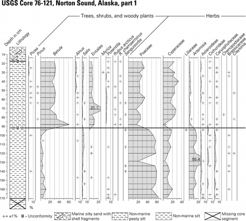
Figure 3 Pollen and spore percentage diagram for USGS Core 76-121, central Norton Sound. Lithology column for the core is shown at the left of the diagram, and radiocarbon dates from the core are listed along the right margin, and in Table 2. See Figure 2 for location of the coring site within Norton Sound.

Figure 3 Continued.

Figure 3 Continued.

Table 2 Radiocarbon ages and calibrated ages for USGS core 76-121. Calibrations follow the Fairbanks 0107 calibration curve (CitationFairbanks et al., 2005). Data from http://radiocarbon.ldeo.columbia.edu/research/radiocarbon.htm on 21 September 2007. The marine reservoir correction for sample NOR-11 is based on data from CitationDumond and Griffin (2002). The USGS conventional bulk-sediment radiocarbon dates shown here were previously reported in CitationElias et al. (1996, Citation1997).

Figure 4 Chart comparing central Beringian vegetation histories derived from pollen records from (1) Kaiyak Lake and (2) Squirrel Lake near Kotzebue Sound, northwest Alaska (CitationAnderson, 1985, 1987); (3) Imuruk Lake, Seward Peninsula (CitationColinvaux, 1964; CitationColbaugh, 1968); (4) USGS Core 76-121, Norton Sound (CitationMuhs et al., 2003; this paper); and (5) Zagoskin Lake, St. Michael Island, Norton Sound (CitationAger, 1983, Citation2003).
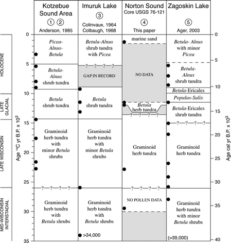
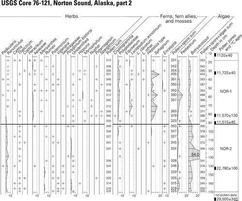
Figure 4 Chart comparing central Beringian vegetation histories derived from pollen records from (1) Kaiyak Lake and (2) Squirrel Lake near Kotzebue Sound, northwest Alaska (CitationAnderson, 1985, 1987); (3) Imuruk Lake, Seward Peninsula (CitationColinvaux, 1964; CitationColbaugh, 1968); (4) USGS Core 76-121, Norton Sound (CitationMuhs et al., 2003; this paper); and (5) Zagoskin Lake, St. Michael Island, Norton Sound (CitationAger, 1983, Citation2003).

Reprints and Corporate Permissions

Please note: Selecting permissions does not provide access to the full text of the article, please see our help page How do I view content?

To request a reprint or corporate permissions for this article, please click on the relevant link below:

Academic Permissions

Please note: Selecting permissions does not provide access to the full text of the article, please see our help page How do I view content?

Obtain permissions instantly via Rightslink by clicking on the button below:

If you are unable to obtain permissions via Rightslink, please complete and submit this Permissions form. For more information, please visit our Permissions help page.